Star.pngStar.pngStar grey.pngStar grey.pngStar grey.png

James Joyce Bridge

From Roader's Digest: The SABRE Wiki
Jump to navigation Jump to search
James Joyce Bridge
Droichead James Joyce
Location Map ( geo)
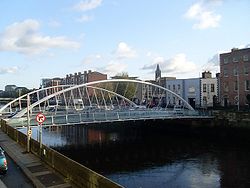
James Joyce Bridge - Geograph - 1578108.jpg
Cameraicon.png View gallery (4)
From:  South Quays (Usher's Island)
To:  Ellis Quay
County
Dublin
Highway Authority
Dublin City
Opening Date
16 June 2003
Additional Information
Bridge Type:  Bowstring Bridge
On road(s)
R805

The James Joyce Bridge carries the R805 across the River Liffey in central Dublin. It is one of the more recent bridges to have been built, having opened in 2003. It forms part of the clockwise Dublin Inner Orbital Route.

The bridge was intended to help reinvigorate the Blackhall Place area of Dublin, while simultaneously reducing traffic levels on the adjacent bridges.


James Joyce Bridge
Related Pictures
View gallery (4)
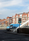
Giant AluStar traffic lights, James Joyce Bridge Dublin - Coppermine - 15569.jpgDublin Inner Orbital J24.jpgJames Joyce Bridge - Geograph - 1578108.jpgJames Joyce Bridge.jpg
Crossings of the River Liffey (An Life)
Ballymuttan Bridge • Ballyward Bridge • Blessington Bridge • Pollaphuca Bridge • Ballymore Bridge • New Bridge • Kilcullen Bridge • M9 Bridge • M7 Bridge • Newbridge Bridge • Victoria Bridge • Carragh Bridge • Lenister Aquaduct • Alexandria Bridge • Straffan Bridge • Celbridge Bridge • M4 Bridge • Leixlip Bridge • Lucan Bridge • West-Link Bridge • Anna Livia Bridge • Islandbridge • Seán Heuston Bridge • Frank Sherwin Bridge • Rory O'More Bridge • James Joyce Bridge • Mellowes Bridge • Father Mathew Bridge • O'Donovan Rossa Bridge • Grattan Bridge • O'Connell Bridge • Butt Bridge • Talbot Memorial Bridge • Samuel Beckett Bridge • Tom Clarke (East-Link) Bridge

SABRE - The Society for All British and Irish Road Enthusiasts
Discuss - Digest - Discover - Help