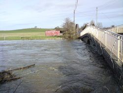
Load Bridge
| Load Bridge | |||
| Location Map ( geo) | |||
 | |||
| |||
| From: | Long Sutton | ||
| To: | Long Load | ||
| Location | |||
| Long Load | |||
| County | |||
| Somerset | |||
| Highway Authority | |||
| Somerset | |||
| Opening Date | |||
| Medieval; 1814 | |||
| On road(s) | |||
| B3165 (Somerset) | |||
| Crossings related to the B3165 (Somerset) | |||
The current Load Bridge stands on the site of an ancient crossing of the Givel Yeo, also known as the River Ivel or River Yeo. The earliest record of a bridge on this site is 1335, but while the current structure has medieval origins it is not believed to be that old! The Yeo used to be navigable at this point, with the rivers providing the main transport links in Medieval Somerset.
The Bridge
The Bridge itself consists of 5 arches, the large central arch through which the river normally flows, and two low flood arches on either side. It was rebuilt in the 18th Century, and further widened in 1814, and appears to have been widened again since with the old stone parapets removed to allow pavements and iron railings to be cantilevered out over the river. However, it is still too narrow for two-way traffic, so the bridge is controlled by signals at either end, although this is rarely a problem, as the B3165 is a quiet road.
| Load Bridge | ||
|
