Star.pngStar grey.pngStar grey.pngStar grey.pngStar grey.png

Lune Bridge

From Roader's Digest: The SABRE Wiki
Jump to navigation Jump to search
Lune Bridge
Location Map ( geo)
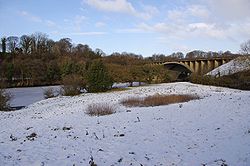
River Lune downstream of M6 bridge - Geograph - 1663211.jpg
Cameraicon.png View gallery (2)
Location
Lancaster
County
Lancashire
Highway Authority
National Highways
Opening Date
1960
On road(s)
M6
Crossings related to the M6

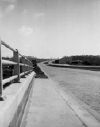
The Lune Bridge is a graceful arch bridge carrying the M6 Lancaster Bypass over the River Lune.


Lune Bridge
Related Pictures
View gallery (2)
River Lune downstream of M6 bridge - Geograph - 1663211.jpgM6 Lancaster By-pass opening day (2) 1960 - Geograph - 2752014.jpg
Crossings of the River Lune
Low Lane Bridge • Raisgill Hall Bridge • Tebay Bridge • M6 - Tebay Bridge • M6 - Tebay Bridge (2) • M6 - Lune Valley Viaduct • M6 - Lune Valley Viaduct(2) • Lincolns Inn Bridge • Killington New Bridge • Devil's Bridge • Stanley Bridge • Lune Bridge • Lune West Bridge • Skerton Bridge • Greyhound Bridge


SABRE - The Society for All British and Irish Road Enthusiasts
Discuss - Digest - Discover - Help