Star.pngStar.pngStar grey.pngStar grey.pngStar grey.png

N23

From Roader's Digest: The SABRE Wiki
Jump to navigation Jump to search
N23
Location Map ( geo)
N23 north of Farranfore - Geograph - 6315167.jpg
Cameraicon.png View gallery (6)
From:  Knockannagore (Q985103)
To:  Farranfore (Q939035)
Distance:  9.5 km (5.9 miles)
Meets:  N21, R577, N22
Highway Authorities

Transport Infrastructure Ireland

Traditional Counties

Kerry

The N23 near Farranfore

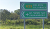
The N23 is a short but important link road in County Kerry which cuts the corner between the N21 at Knockannagore near Castleisland and the N22 at Farranfore. One of its main purposes is to serve Kerry Airport at the latter place.


N23
Junctions
Places
Miscellaneous
Related Pictures
View gallery (6)
Entrance to Kerry Airport - Geograph - 4683386.jpgN23N23 SignN23 north of Farranfore - Geograph - 6315167.jpgN23 RCS.jpg
Other nearby roads
Killarney
N22 • N71 • N72 • R562 • R563 • R569 • R876 • R877 • Ring of Kerry • T29 • T30 • T65 • T67
Castleisland
L9 • N21 • R577 • T28 • T28A • T29A
National Roads and Motorways of Ireland
MotorwaysM1 • M2 • M3 • M4 • M6 • M7 • M8 • M9 • M10 • M11 • M12 • M13 • M14 • M15 • M16 • M17 • M18 • M20 • M21 • M25 • M28 • M32 • M40 • M50
National PrimaryN1 • N2 • N3 • N4 • N5 • N6 • N7 • N8 • N9 • N10 • N11 • N12 • N13 • N14 • N15 • N16 • N17 • N18 • N19 • N20 • N21 • N22 • N23 • N24 • N25 • N26 • N27 • N28 • N29 • N30 • N31 • N32 • N33 • N40 • N50
National SecondaryN51 • N52 • N53 • N54 • N55 • N56 • N57 • N58 • N59 • N60 • N61 • N62 • N63 • N64 • N65 • N66 • N67 • N68 • N69 • N70 • N71 • N72 • N73 • N74 • N75 • N76 • N77 • N78 • N79 • N80 • N81 • N82 • N83 • N84 • N85 • N86 • N87

SABRE - The Society for All British and Irish Road Enthusiasts
Discuss - Digest - Discover - Help