Star.pngStar.pngStar.pngStar grey.pngStar grey.png

N5

From Roader's Digest: The SABRE Wiki
Jump to navigation Jump to search
N5
Location Map ( geo)
N5 - Westport to Turlough -open to traffic-
Cameraicon.png View gallery (11)
From:  Aghadegnan (Longford bypass) (N127772)
To:  Westport (L996844)
Distance:  132.1 km (82.1 miles)
Meets:  N4, R371, R368, N61, R376, R369, R361, R293, N17, N26, R375, R320, R321, N58, R309, N60, R307, N84, R308, N59
Highway Authorities

Transport Infrastructure Ireland

Traditional Counties

Longford • Mayo • Roscommon

Approaching Westport on the N5

The N5 – starting at a junction with the N4 on the Longford bypass at Aghadegnan, 2 km northwest of the town centre, and ending in Westport in County Mayo – is a national primary road that connects the midlands of Ireland to the country's central west coast.

Route

Charlestown Bypass.

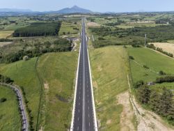
The N5 currently starts on the N4 northwest of Longford and follows a recently built western bypass of the town, before turning right at Ballyminion to resume its original route. The road crosses the River Shannon to enter County Roscommon at Terronbarry and runs through Strokestown and Tulsk before turning more towards the northwest and traversing the rural parts of the county. We enter County Mayo along the 13.5-km Ballaghaderreen bypass (opened on 2 September 2014) then cross the N17 Atlantic Corridor Route at a grade-separated junction near Charlestown. There is then a bypass of Swinford, where the N26 heads towards the north of the county, while the N5 turns to run southwesterly to run past Castlebar on a dual carriageway bypass and onward to Westport, where it ends on the northern bypass of the town on the N59 coastal route.

History

The N5 (like the N3) is not a direct descendant of one of the earlier T-roads radiating from Dublin. Instead it consists of a medley of various former T- and L-roads – mostly the T77 as far as Swinford. The route originally ended at Castlebar, with the road from there to Westport being part of the N60, but this final section was renumbered N5 upon being upgraded to national primary status.

The original startpoint of the N5, as classified in 1977, was the top end of Main Street in Longford, which was a part of the N4 at the time. It was moved onto the Longford Western Bypass when that road opened in 2011. When the Westport to Turlogh dual carriageway opened in 2023. The old route through Castlebar and Westport was reclassified as the R309

Links


Videos

N5 Turlough to Westport

N5 Turlough to Westport

Watch video > >


N5
Projects
Junctions
Crossings
Places
Miscellaneous
Related Pictures
View gallery (11)
N5 Westport Bohola preferred route - Coppermine - 21089.jpgApproaching Westport, County Mayo - Geograph - 1865264.jpgWestport Bridge.jpgOverbridge, N5 - Geograph - 7165001.jpgN5 - Westport to Turlough -open to traffic-
Other nearby roads
Longford
L21 • N4 • N63 • R194 • R198 • R393 • R397 • T3 • T15 • T77
Charlestown
N17 • T11 • T77
Swinford
L21 • L27 (Cadamstown - Swinford) • N26 • N57 • R320 • R375 • T77
Castlebar
L21 • N58 • N60 • N84 • R306 • R307 • R308 • R309 • R310 • R311 • R312 • R373 • R917 • T39 • T40
Westport
N59 • N60 • R306 • R330 • R335 • T39 • T71 • Wild Atlantic Way
National Roads and Motorways of Ireland
MotorwaysM1 • M2 • M3 • M4 • M6 • M7 • M8 • M9 • M10 • M11 • M12 • M13 • M14 • M15 • M16 • M17 • M18 • M20 • M21 • M25 • M28 • M32 • M40 • M50
National PrimaryN1 • N2 • N3 • N4 • N5 • N6 • N7 • N8 • N9 • N10 • N11 • N12 • N13 • N14 • N15 • N16 • N17 • N18 • N19 • N20 • N21 • N22 • N23 • N24 • N25 • N26 • N27 • N28 • N29 • N30 • N31 • N32 • N33 • N40 • N50
National SecondaryN51 • N52 • N53 • N54 • N55 • N56 • N57 • N58 • N59 • N60 • N61 • N62 • N63 • N64 • N65 • N66 • N67 • N68 • N69 • N70 • N71 • N72 • N73 • N74 • N75 • N76 • N77 • N78 • N79 • N80 • N81 • N82 • N83 • N84 • N85 • N86 • N87

SABRE - The Society for All British and Irish Road Enthusiasts
Discuss - Digest - Discover - Help