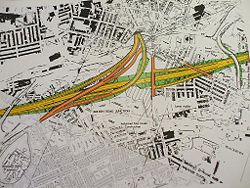
Nova Scotia Interchange
| Nova Scotia Interchange | |||
| Location Map ( geo) | |||
 | |||
| |||
| Location | |||
| Blackburn | |||
| County | |||
| Lancashire | |||
| Junction Type | |||
| Hybrid fork | |||
| Roads Joined | |||
| (Unbuilt) M65, A666, A679, (former) B6232, now A6077 | |||
The Nova Scotia Interchange was an ambitious part of the unbuilt M65 proposals from 1974. It would have connected the M65 to the Blackburn Inner Relief Route via an impressive 40 feet high viaduct over both the existing road network and the East Lancashire Line. It featured in both the Blue and Brown route proposals for the motorway, and had a design speed of 70mph.
It was shelved in 1980 and later formally abandoned in 1987 when the M65 was finalised to bypass Blackburn to the south.
The current junction on the A6078 was constructed in 1970, four years before the M65 plans were finalised, and the dual carriageway section of the A666 would have been in use to filter traffic onto the sliproads for the Inner Relief Route. The original junction was modified in 2001 when the A6078 was created.
| Nova Scotia Interchange | ||||||
| ||||||
| ||||||
|


