OS Half Inch
| Half Inch | |||
 | |||
| |||
| Publisher: | Ordnance Survey | ||
| Scale: | 1:126,720 | ||
| First Published: | 1902 | ||
| Final Publication: | 1989 | ||
| SABRE Maps layer: | Yes | ||
The OS Half Inch maps were several series of maps covering all or part of Great Britain. They were used as the base mapping for the Ministry of Transport Road Maps.
First Series
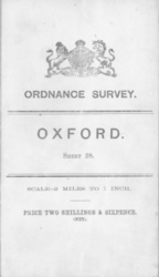
The first series of half-inch maps of England and Wales were produced at the start of the 20th century. Planned coverage of 104 sheets was not completed, and this format was abandoned after 88 sheets were published. A revision (the Large Sheet Series), on a larger sheet base was produced in 1906-8, covering England and Wales in 40 sheets, and Scotland in a further 30. The mapping was based on reduced One Inch Third Edition mapping, and so in some places the base mapping was from the Victorian era.
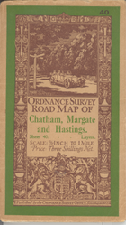
This format continued with periodical revisions until the mid-1930s, with confusing covers for the standard edition using the phrase Ordnance Survey Road Map - easily mistaken for the OS Ministry of Transport Road Maps.
The Large Sheet series used the Cassini (Delamere) projection for the England and Wales sheets, whilst the Scottish sheets used the Bonne (Scotland) projection.
Sheetlines
The sheetlines of the Large Sheet series are identical to those of the Ministry of Transport Maps
1930s District Sheets
Five so-called District maps (with various revisions) were produced in the 1930s based upon the then-new National Yard Grid and produced in a similar style to One Inch Fifth Edition mapping. This included several Greater London sheets from 1935 to 1946, which whilst all were on the same sheetlines and formats, the post-war maps do not show either the National Yard Grid that they were based upon, or the new National (metric) Grid.
Second Series
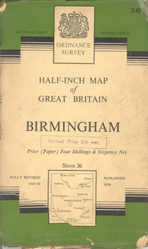
A second series was planned to cover Great Britain in 51 sheets, however only five sheets were published between 1958 and 1962: a provisional edition of Sheet 51, Canterbury, and the Second Series proper, consisting of Sheet 28, Snowdon, Sheet 36, Birmingham and Sheet 39, Norwich. The series was cancelled just as the fifth sheet, Greater London, was being produced, so it was issued without a number and remained on sale until the late 60s. What would have been Sheet 37, Leicester, got to the proof stage as the series was cancelled and so was never issued in period, although the Charles Close Society have now printed copies of this map, and copies are available from their website.
Following the cancellation of the series, maps within it were packaged in a new cover and labelled as District Maps, but they are the same maps within.
The half-inch scale lived on in the map of Snowdonia - a revised OS Tourist sheet was issued in 1966 with revisions until 1986, making it one of the last pre-metric OS maps still on sale.
OS City Link Maps
In 1986, well after the vast majority of OS maps had changed to metric scales, another brief series of Half Inch maps was produced - starting with the "M25 and London" sheet produced to mark the opening of the last section of M25. Four sheets in the series were produced, with the final ones being published in 1989. They were photographically enlarged Routemaster maps.
SABRE Maps coverage
There is now some minor OS Half Inch series mapping on SABRE Maps, although these layers are focussed on OSI and OSNI mapping which is much more common.
The exception to this rule, is, of course, the MoT Map coverage, which is a variant of the Half Inch series.
- OS Half Inch covers
1900s style cover
1920s style cover
1958-62 series cover


| OS Half Inch | ||||||||
| ||||||||
|


-map.png)
