OS Ten Mile Map
| Ten Mile Map | |||
 | |||
| |||
| Publisher: | Ordnance Survey | ||
| Scale: | 1:625,000 | ||
| SABRE Maps layer: | No | ||
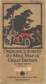
The Ten-Mile Map of Great Britain were an Ordnance Survey mapping series, most commonly confused in this context with the Ten-Mile Road Map. Standard Ten-Mile Maps do not contain road numbers on them, although major roads are marked. Confusingly, the standard Ten-Mile Map cover shows a motorist consulting a map.
Later editions covered Great Britain in two sheets, with Sheet 1 covering Scotland, and England south to roughly a line joining Ravenglass on the Cumberland coast with Ravenscar on the Yorkshire side. Editions before about 1930 covered Great Britain in three overlapping sheets, with Sheet 1 covering northern and mid-Scotland as well as the northern tip of Northumberland; sheet 2 covering the area roughly bounded by the Isle of Mull and Dundee on the northern side, and the Llŷn Peninsula and the northern half of Norfolk on the southern side; whilst Sheet 3 covered roughly the area south of southern Lancashire and the Humber Estuary.
Ten Mile Maps came in several different types, often referred to as "Planning Series". As well as the standard "Ten Mile Map" and the familiar Ten-Mile Road Map, other specialised Ten Mile maps included rainfall, geology, accessibility (what we would call "Travel to Work Areas" today), railways, population density and farming.
SABRE Maps coverage
There is no coverage of "standard" Ten Mile mapping on SABRE Maps.
Sheetlines
The three-sheet style of Ten Mile Map is on the Cassini (Delamere) projection, with the below sheetlines. The two-sheet series all are either to the National Yard Grid or the National Grid, and so have co-ordinates that can be read from the sheets.
| Sheet | Top left corner | Bottom right corner |
|---|---|---|
| 1 | -190.69886:428.73617 | 189.30114:168.73617 |
| 2 | -190.69886:228.73617 | 189.30114:31.26383 |
| 3 | -190.69886:25.73617 | 189.30114:-231.26383 |
| OS Ten Mile Map | ||||||||
| ||||||||
|
