Star.pngStar grey.pngStar grey.pngStar grey.pngStar grey.png

Peckfield Bar

From Roader's Digest: The SABRE Wiki
Jump to navigation Jump to search
Peckfield Bar
Location Map ( geo)
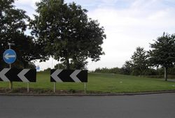
Peckfield Bar - Geograph - 223606.jpg
Cameraicon.png View gallery (1)
Location
SE of Garforth
County
Yorkshire
Highway Authority
Leeds
Junction Type
Roundabout
Roads Joined
A63, A656
Junctions related to the A656

The junction of the A63 and the A656.

The A63 runs from Leeds to Kingston upon Hull

The A656 runs from Castleford to Parlington. This was a straight Roman Roman Road from the barracks at Castleford known as Ridge Street.

Routes

Route To Notes

A63

The SOUTH (A1(M)), Selby

A63

(M1), Leeds, Airport

A656

Wetherby (A1(M), York (A64)

A656

Castleford, Pontefract (A639)


Peckfield Bar
Related Pictures
View gallery (1)
Peckfield Bar - Geograph - 223606.jpg
Junctions on the A63
Hunslet • Knowsthorpe Gate Roundabout  • Thornes Farm Roundabout • Bell Wood Roundabout  • East Leeds Link Interchange • Austhorpe Interchange  • Garforth Roundabout • Peckfield Bar  • Selby Fork  • Selby Fork Interchange  • Monk Fryston Roundabout • Thorpe Willoughby Roundabout • Selby Bypass Roundabout • Sugar Factory Roundabout • Barlby Junction • North Cave Interchange  • South Cave Interchange • Ferriby Interchange • Brighton Street Interchange • Hessle Road Interchange • Mytongate  • Great Union Street • Southgates


SABRE - The Society for All British and Irish Road Enthusiasts
Discuss - Digest - Discover - Help