Peterborough
| Peterborough | |||
| Location Map ( geo) | |||
 | |||
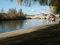
| Town Bridge, Peterborough | |||
| |||
| County | |||
| Northamptonshire | |||
| Highway Authority | |||
| Peterborough | |||
| Forward Destination on | |||
| A1 • A15 • A47 • A605 • A1139 • A1260 | |||
| Next Primary Destinations | |||
| Huntingdon • Leicester • March • Sleaford • Stamford • Wellingborough | |||
| Places related to the A1 | |||
Edinburgh • Gateshead • Pontefract • Newcastle upon Tyne • Stamford • Huntingdon • Newark-on-Trent • Grantham • Morpeth • Alnwick • Berwick-upon-Tweed • Boroughbridge • Barnet • Potters Bar • Central London • The City • Haddington • Stevenage | |||
| Places related to the A1(M) | |||
| Places related to the A15 | |||
| Places related to the A16 | |||
| Places related to the A47 | |||
Leicester • Birmingham • March • Wisbech • Hinckley • Nuneaton • Swaffham • Norwich • Great Yarmouth • Kings Lynn • Dereham • Lowestoft | |||
For the Highway Authority, see Peterborough Council.
Peterborough is a cathedral city in the east of England. It stands on the ECML and near the Great North Road.
History
Soke Parkway (A47)
Stage 1 (West section) - A47 Thorpe Wood Interchange to A15 Lincoln Road was opened on 5 October 1972. The 3 mile dual carriageway cost £2 million. It included a new bridge over the East Coast Main Line, two other road bridges, two footbridges, five pedestrian subways and a big footbridge complex at Lincoln Road Interchange. It was the first section of a 34 mile planned parkway system, as the city was expected to double in size over the next 15 years. The Parkway name came from the intensive tree and shrub planting along them. It was initially unclassified until the east section opened.
Stage 2 (east section) - A15 Lincoln Road to Eye Road. The eastern part is now part of Paston Parkway. Shown on April 1975 OS Quarter inch map, not on March 1974 edition. It completed the Northern Bypass.
Fletton Parkway (A1139)
Stage 1 - The 2.5 mile D2 dual carriageway road from A1 Fletton Parkway Interchange to Hampton Roundabout, Nene Parkway was opened on 19 July 1976. Contractor was Mears Construction, outturn works cost £3.9 million.
Stage 2 - 1.8 mile dual carriageway from Hampton Interchange to Stanground Interchange. Cambridge Daily News of 21 August 1981 had a job advert which stated that construction would commence in September 1981 and was anticipated to be completed within 2 years. A further job advert on 2 July 1982 required a temporary Works Inspector for the road under construction for approximately 6 months. Shown as under construction on the February 1983 OS 1:250000 map.
Orton Parkway (A1139)
The D2 dual carriageway road from Oundle Road to Orton South Interchange, Fletton Parkway was opened on 19 July 1976. Forecast cost was £361,000. It was stage 1 but subsequent stages were never built.
Frank Perkins Parkway (A1139)
South section. The dual carriageway from Boongate to Stanground Interchange, including Black Bridge over the River Nene, was opened in 1985 per the Peterborough Civic Society. It was included on the 1986 Philips Road Atlas and was under construction on the 1984 edition.
North section. The 2 mile dual carriageway from Eye Road Roundabout to Boongate was reported as opened by the Lynn Advertiser of 23 October 1987. Cost £6.3 million. It completed the City's Parkway network.
Longthorpe Parkway (A1179)
The dual carriageway from Thorpe Interchange on Nene Parkway to Thorpe Road was shown as opened on the April 1975 OS Quarter inch map. It was under construction on the April 1974 edition. It may have initially been unclassified.
Nene Parkway (A1260)
It was mentioned as opened in a 16 May 1975 golf course advert in Stamford Mercury. It was shown as opened (and unclassified) on the April 1975 OS Quarter inch map and was under construction on the April 1974 edition. It may have opened in 1974. A connection from Hampton Roundabout to A15 London Road along Phorpres Way opened at the same time (then A1139).
Routes
| Route | To | Notes |
| London, Huntingdon | Accessed via A1139.Huntingdon is reached via A14(M) | |
| The NORTH, Stamford | Accessed via A1260 & A47. Stamford is reached via A43 | |
| Sleaford | Also forms Peterborough North East Bypass | |
| Spalding | ||
| Wisbech, King's Lynn | Accessed via A1260 | |
| Leicester | Accessed via A1260 | |
| Northampton, Oundle | ||
| Peterborough East/South Bypass | ||
| Peterborough West Inner Bypass | ||
| Werrington | ||
| Yaxley | ||
| Whittlesey | ||
| Fletton | ||
| Farcet, Yaxley | Light Traffic Only | |
| Pondersbridge, Ramsey | ||
| Crowland, Eye Green |


