Pre-Worboys
| Pre-Worboys | |
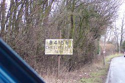 | |
| Pre-Worboys Route Confirmation Sign from B4156, Staffordshire | |
| Pictures related to Pre-Worboys View gallery (42) | |
Pre-Worboys refers to signs installed before the Worboys report of 1964. They were last sanctioned in the Traffic Signs Regulations and General Directions 1957.
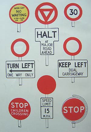
Warning and regulatory signs were primarily text based, with pictograms used to represent common hazards, such as traffic signals and roundabouts. The nature of the hazard was usually shown on a black on white sign below the standard warning symbol. The top of the sign used a hollow red triangle for hazards, and either a solid or hollow red disc for regulations - symbols which to this very day are internationally recognisable.
They differ from modern signs in that they used an upper text typeface (known on SABRE as Llewellyn-Smith after the committee that created it), and prominence was given to route numbers over destinations on direction signs. The coming of the motorway network brought about the Anderson report and, after several experiments, the Worboys report saw the eventual demise of the original system.
The Pre-Worboys system was reviewed in 1944 by the Report of the Departmental Committee on Traffic Signs 1944.
Warning Signs
 | |
| Pictures related to Pre-Worboys Warning Signs View gallery (167) | |
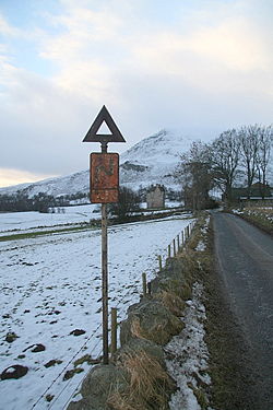
There was a list of different road hazards, each presented on an oblong plate with a line in the bottom quarter with the name of the hazard below in upper case and a picture of it above. Other information signs used as warnings had the text underneath on a panel with no picture, such as 'gated road ahead' with the red triangle above.
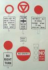
Changes were made in 1955 (see left) with the new font and a few different pictures, mainly the schoolchildren replacing the flame for the school, and the crossroads becoming a cross standing on its point where the previous was shown diagonally positioned. The double bend symbol was also put at a different angle. These changes were made just nine years before the complete demise of the system; however it does seem that the changes were fairly widespread, given that the vast majority of modern day survivors are to these post-1955 standards.
Normally the plates came in standard and large sizes while the triangles were one size, with or without reflectors. Earlier plates were cast metal; later ones used reflective Scotchlite.
Regulatory Signs
 | |
| Pictures related to Pre-Worboys Regulatory Signs View gallery (56) | |
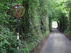
Like warning signs, regulatory signs had a red plate on the top of the sign - this time circular. Oddly, some plates were hollow, and others were solid discs, depending on whether the regulation was positive or negative (very similar to the difference between today's blue and red circular signs).
However, there was little consistency with this system, and numerous signs had designs very similar to modern day signs, with the nature of the restriction on the circular plate itself. These included parking restrictions, speed limit signs (see below), No Entry signs (almost exactly the same as today's signs, aside from the text), and No Cycling signs, which was written in text form rather than using a pictogram.
Interestingly, pictograms and symbols were almost never used on regulatory signs - they only ever made an appearance on the "Halt at major road ahead" and "Slow - major road ahead" signs (the latter amounting as much to a warning sign as to a regulation). These signs were surmounted by a triangle within a circle.
Speed Limit Signs
 | |
| Pictures related to Pre-Worboys Speed Limit Signs View gallery (50) | |
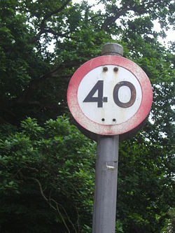
There were two types of these, the red circles for 30mph and above (only introduced towards the end of the era) and for below 30mph they were made like the warning signs with the limit in numbers, 'speed limit' below in upper case, and a red circle on the top. Originally there was only a 30mph and no upper limit, and when new laws came in then there was a period of 40 and (less commonly) 50mph limits as well. A 60mph limit on the Birmingham-Rugby A45 dual carriageway was uniquely introduced shortly before Worboys signs was introduced, with its own signage. Otherwise roads were "derestricted", no limit at all. The 70mph limit on otherwise derestricted roads only came in the late 1960s after Worboys signage was introduced, it applied throughout and not just on motorways.
Direction Signs
 | |
| Pictures related to Pre-Worboys Direction Signs View gallery (301) | |
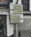
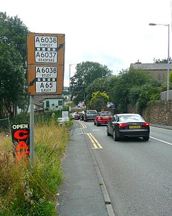
Direction signs came in the same three basic layouts that are used today - map signs, list signs and flag signs. Distinctions were also made between the main signage and local signage, through colour coding. However, there was numerous variations of this colour coding (see left).
Through Routes are easily distinguishable by the fact that they are the ADS signs with road numbers displayed. Stack forms of the sign only came in one variation (bottom of middle column), whilst map signs were yellow in urban areas, and white in rural areas. Black signs were also used in rare, generally rural, situations, but the reason for the unique colouring is unknown.
Local routes were only ever shown in stack signs, and were generally coloured blue for urban areas, and black for rural areas.
Flag signs for through routes were dominated by the route numbers, with the appropriate destinations underneath. These were yellow in urban areas, and white in rural areas. Local routes in urban areas were signed on blue signs, and on black and/or white signs in rural areas.
There were occasional variations (e.g. blue map signs), but these are thought to be extremely rare, if not extinct.
The design of the signs was simple, and fairly consistent. Road numbers had pride of place on through route signage, being on top in the box and in a much larger font size. Other roads nearby (now signified today with brackets) were highlighted with a black and white strip along the top of the appropriate panel, with any further routes beyond that signed in brackets (see left column in diagram). On Through Route signs, only one or two destinations were signed, with any other local towns and villages being signed on the local signs, complete with mileage.
Fingerpost Signs
 | |
| Pictures related to Pre-Worboys Fingerpost Signs View gallery (281) | |
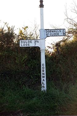
Unlike the other British signs these were used on smaller roads, mainly rural, and unaffected by the regulations. There is a basic standard design, but many earlier ones survive and there is a fairly free rein for local authorities to create their own designs as well as produce ones very similar to those almost 100 years old. Besides black and white with upper case there are ones in negative, green used for footpaths, many in wood, and red in Dorset with white lettering. Like other signs early B roads were also shown in negative, although usually on the tip of the pole where road numbers normally go, and the rest being in positive. There are regulations requiring local authorities to maintain fingerposts, painting them every five years and replacing them with similar alternatives. Unfortunately many can be found which appear to never have been painted since their creation. The earliest (some have survived including one on a wall in Chertsey, Surrey) have an actual finger instead of an arrow.
In construction they were principally made in a foundry, of cast iron. The large fingerboards themselves have a hinge cast in at the post end, and the posts themselves are circular. The fingerboards are dropped over the top and then swung appropriately. It has long been difficult for rural children to resist the temptation to swing the fingerboards around so they point in the incorrect direction, a strenuous but not impossible misdemeanour. Quite why such a readily-modifiable arrangement was used is not apparent. A passing village policeman would see it as part of their duties to correct them.
Information Signs
 | |
| Pictures related to Pre-Worboys Information Signs View gallery (149) | |
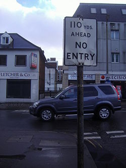
These are general signs not covered above, for local features such as the one illustrated, which are not to prohibit but inform drivers of specific road conditions. Many have route information, saying 'no access to Kingsway' or 'Left lane for Waterloo Bridge' etc. which were both on Aldwych in London. Modern signs often are almost the same save the different font, and choose almost randomly between lower case or all capitals. Pre-Worboys were usually in black on white, but a section were blue, mainly the familiar square 'to car park' with the arrow, and 'way out' above an arrow. There is a yellow panel sign 'To public library' with an arrow below, and the familiar 'to public conveniences/toilets on an arrow sign.
Through direct research of sign usage there are three types of no through road signs. Unlike you'd think, the basic no through road, still occasionally used instead of the pictogram but in the modern font, does not just mean dead end, but also a crescent, as a road in Shepherds Bush W12 has one at either end although definitely not a dead end. Cul-de-sac does mean a dead end, and was issued along with no through road signs by local councils on a single line (rather than three for no through roads) and as not covered by Worboys are still widespread, particularly in Surrey where they issued far more than most. The third category, 'no through road for motor vehicles' is for dead ends which end in a footpath or bridle path so people, cycles and possibly animals can get through but nothing else.
Milestones
 | |
| Pictures related to Milestones View gallery (254) | |
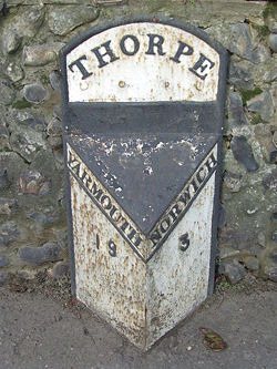
Milestones originally date back as far as Roman times, however the ones we see at the roadside today became common in 1767, when they became compulsory on all Turnpike roads. These were erected and maintained by the road's owner. However, when Turnpikes were handed over to the county and local councils in 1888, so were the milestones. Many were replaced with cast iron 'stones', of which many still exist today.
Motorway Signs
Before 1965, motorway signs were subject to the findings of the Anderson report.
Links
- Roads.org.uk: A In depth detail about Pre-Worboys signs
- CBRD: Pictures of Pre-Worboys Signs (archive.org)
- DavidNW9s Pre-Worboys sign photos
- Flickr Pre-Worboys pool

