Star.pngStar.pngStar grey.pngStar grey.pngStar grey.png

R111

From Roader's Digest: The SABRE Wiki
Jump to navigation Jump to search
R111
Location Map ( geo)
Cameraicon.png View gallery (35)
From:  Conyngham Road, Dublin (O127344)
To:  Beach Road, Irishtown (O186334)
Via:  Portobello
Distance:  7.4 km (4.6 miles)
Meets:  R109, R148, R839, R810, R811, R812, R110, R137, R114, R117, R138, R816, R118, R815, R131, R802
Highway Authorities

Dublin City

Traditional Counties

Dublin

Dolphin Road.
The R111 shadows the Grand Canal, with space for a hypothetical dual carriageway.

The R111 forms an important part of the Dublin Outer Orbital Route, carrying traffic from the eastern side of the city towards the routes out to the west. For most of its route, it runs along the southern bank of the Grand Canal.

It starts at the junction with the R131 in Irishtown. The R111's status as a major route is hindered by the narrow crossing of the Dodder on London Bridge, and then under the low bridge at South Lotts.

At Macartney Bridge, the road begins to shadow the Grand Canal. It meets several key routes, before handing over most of its traffic at Suir Road. From here the R111 moves from its wide and straight alignment to a more claustrophobic affair, as it passes through Kilmainham and over the Camac River. Here it merges with the South Circular Road.

After a brief bit of 1980s gyratory at the R148, the R111 squeezes through Islandbridge, ending at a junction with the R109 near Phoenix Park.

There have been several plans to cover up the Grand Canal, and use the space created to build a dual carriageway. The General Traffic Plan of 1965 called for it to be D3 with local access roads. This met with complaints about the canal being covered up and concerns that it would just fill up with traffic. In 1971, with more new roads proposed, it was decided to downgrade this one to a scenic D2, though before that decision was made a number of potential new diamond GSJs were considered. No improvements were ever built, anyway.
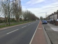


R111
Crossings
Roads
Places
Related Pictures
View gallery (35)
Suir Road, Kilmainham - Geograph - 2343471.jpgDublin Outer Orbital J59.jpgDublin Outer Orbital former J54.jpgDublin Outer Orbital former J83 2.jpgKilmainham Bridge.jpg
Other nearby roads
Dublin
Dublin Inner Orbital Route • Dublin Outer Orbital Route • E01 • E20 • E104 (Dublin - Killeen) • E105 (Dublin - Rosslare) • E107 (Dublin - Cork) • E108 (Dublin - Shannon) • E118 (Old System) • E122 (Old System) • E124 (Old System) • E125 (Old System) • E126 (Old System) • EuroVelo 2 • Fairview Spur • L1 • L6 • M1 (Republic of Ireland) • M11 (Republic of Ireland) • M32 (Republic of Ireland) • M50 (Republic of Ireland) • N1 • N2 • N3 • N4 • N7 • N11 • N31 • N32 • N50 • N81 • R101 • R102 • R103 • R104 • R105 • R106 • R107 • R108 • R109 • R110 • R112 • R113 • R114 • R115 • R117 • R118 • R121 • R122 • R123 • R124 • R131 • R132 • R133 • R134 • R135 • R137 • R138 • R147 • R148 • R801 • R802 • R803 • R804 • R805 • R806 • R807 • R808 • R809 • R810 • R811 • R812 • R813 • R814 • R815 • R816 • R817 • R818 • R819 • R820 • R824 • R825 • R833 • R834 • R839 • R840 • T1 • T2 • T3 • T5 • T7 • T35 • T42 • T43 • T44 • T5A
Dublin Port
R100-R199
R100 • R101 • R102 • R103 • R104 • R105 • R106 • R107 • R108 • R109 • R110 • R111 • R112 • R113 • R114 • R115 • R116 • R117 • R118 • R119
R120 • R121 • R122 • R123 • R124 • R125 • R126 • R127 • R128 • R129 • R130 • R131 • R132 • R133 • R134 • R135 • R136 • R137 • R138 • R139
R140 • R141 • R142 • R143 • R144 • R145 • R146 • R147 • R148 • R149 • R150 • R151 • R152 • R153 • R154 • R155 • R156 • R157 • R158 • R159
R160 • R161 • R162 • R163 • R164 • R165 • R166 • R167 • R168 • R169 • R170 • R171 • R172 • R173 • R174 • R175 • R176 • R177 • R178 • R179
R180 • R181 • R182 • R183 • R184 • R185 • R186 • R187 • R188 • R189 • R190 • R191 • R192 • R193 • R194 • R195 • R196 • R197 • R198 • R199

SABRE - The Society for All British and Irish Road Enthusiasts
Discuss - Digest - Discover - Help