Samlesbury Interchange
| Samlesbury Interchange | |||
| Location Map ( geo) | |||
 | |||
| |||
| Location | |||
| Samlesbury | |||
| County | |||
| Lancashire | |||
| Highway Authority | |||
| National Highways | |||
| Junction Type | |||
| Dumbbell | |||
| Roads Joined | |||
| M6, A59 | |||
| Junctions related to the A59 | |||
Broughton Roundabout (Skipton) • Allerton Park Interchange • Bidston Island • Queens Drive Flyover • Empress Roundabout • Haw Park Roundabout • Ripley Store • Tarleton Bypass • Five Barred Gate • Penwortham Flyover • Langho Roundabout • Whalley Roundabout • Pendleton Roundabout • Bond End • Goldsborough Caravan Site Roundabout • Switch Island • Hutton Interchange • Robbins Bridge Roundabout • Gargrave Road Roundabout | |||
Samlesbury Interchange: junction 31 of the M6, and informally referred to as the Tickled Trout by locals as the hotel and service area on the westernmost roundabout go by this name – has the honour of being the UK's first grade separated motorway junction, opened in December 1958. Originally opened as a partial cloverleaf interchange with two roundabouts to avoid extra bridges over the River Ribble, it was completely rebuilt between 1993 and 1995 when the M6 was improved between junctions 30 and 32. The original alignment of the A59 still exists as a cycle facility avoiding both roundabouts.
In the 1970s, proposals were made to replace this junction with a more modern design in order to accommodate an improved A59 and A677 towards Blackburn. This plan was later abandoned and the junction remained unchanged until the 1990s widening.
The A59 to the east was not dualled until 1963, but the original junction design needed next to no alterations to accommodate this improvement.
An unusual and interesting feature of this interchange is that each of the two bridges carrying the north-facing slip roads over the Ribble has a two-lane main carriageway for traffic joining or leaving the motorway, and a all-purpose single-lane "contraflow" carriageway to provide access to, or egress from, sandpits/quarries and the Brockholes Nature Reserve on the north side of the river. Thus in the 1990s improvement the total number of lanes and hard shoulders crossing the river was increased from 6 to 16.
Other interesting features of this interchange are the Police Compound and three commemorative plaques. The Police Compound which has existed since 1958 albeit with many changes, lies in the south-western sector of the interchange. The first plaque celebrating the original opening of the M6 Preston Bypass was unveiled in December 1958 and lies immediately to the south of the westbound A59, just after it passes under the M6 overbridge. The second plaque commemorating the 1993-1995 widening work of the M6 Preston Bypass was unveiled near the first plaque in October 1995 however this has become covered with bushes over the years. The third plaque celebrating 50 years of the M6 was unveiled in December 2008 and lies immediately to the north of the eastbound A59, just before it passes under the M6 overbridge.
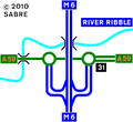
In 2010, the junction was signalised and turned into a 'teardrop' dumbbell as part of an ongoing series of improvements to the A59 corridor to connect with the expanded BAE Samlesbury site.
Strip Maps
Salmesbury Interchange as it was in 1958
Salmesbury Interchange as it was in 1967
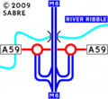
Salmesbury Interchange as it was in 2009
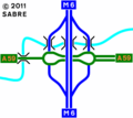
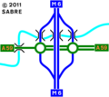
The current layout of the interchange.


Grid Reference
Routes
| Route | To | Notes |
| The NORTH, Lancaster, Blackpool (M55) | ||
| The SOUTH, Birmingham | ||
| Clitheroe, Blackburn (A677) | ||
| Preston | ||
| Services, Hotel |


