Star.pngStar.pngStar grey.pngStar grey.pngStar grey.png

Sandelford Bridge

From Roader's Digest: The SABRE Wiki
Jump to navigation Jump to search
Sandelford Bridge
Location Map ( geo)
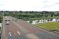
Coleraine ring road - Geograph - 190450.jpg
Cameraicon.png View gallery (6)
From:  Lodge Road Roundabout
To:  Strand Road Roundabout
Location
Coleraine
County
Londonderry
Highway Authority
DfI Roads
Opening Date
1975
Additional Information
Bridge Type:  Girder Bridge
On road(s)
A29
A dedication plaque marking the name of the bridge from the opening in 1975

Sandelford Bridge, also unofficially known as Mountsandel Bridge is a box-girder bridge carrying the Coleraine Ring Road over the River Bann.


Sandelford Bridge
Related Pictures
View gallery (6)
Coleraine ring road - Geograph - 190450.jpgThe Sandelford Bridge, Coleraine - Geograph - 728977.jpgThe Sandelford Bridge, Coleraine (1980) - Geograph - 3382945.jpgThe Sandelford Bridge, Coleraine (2) - Geograph - 2898033.jpgBridge plaque, Coleraine - Geograph - 2898069.jpg
Crossings of the River Bann
Upper BannNew Bridge • Eight Mile Bridge • Lisnamulligan Bridge • Ballycoshone Bridge • McCombs Bridge • Bannfield Bridge • Roughan Bridge • Ballyroney Bridge • Seafin Bridge • Kate McKay's Bridge • Poland's Bridge • Mulligan's Bridge • Ballievey Bridge • Lisnaree Bridge • Lindsay's Bridge • A1 Bridge • Bann Bridge (Banbridge) • Huntly Bridge • Lawrencetown Bridge • Tullylish Bridge • Gilford Bridge • White Bridge • Dynes Bridge • Bann Bridge (Portadown) • Shillington Bridge • M1 Bridge
Lower BannToome Bridge • New Toome Bridge • Bann Bridge (Portglenone) • Kilrea Bridge • Agivey Bann Bridge • Bann Bridge (Coleraine) • Sandelford Bridge


SABRE - The Society for All British and Irish Road Enthusiasts
Discuss - Digest - Discover - Help