Star.pngStar.pngStar grey.pngStar grey.pngStar grey.png

Seven Meadows Bridge

From Roader's Digest: The SABRE Wiki
Jump to navigation Jump to search
Seven Meadows Bridge
Location Map ( geo)
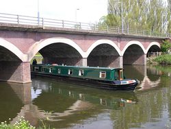
Bridge over River Avon, Stratford-upon-Avon - Geograph - 1834401.jpg
Cameraicon.png View gallery (1)
County
Warwickshire
Highway Authority
Warwickshire
Opening Date
1990
Additional Information
Bridge Type:  Arch
On road(s)
A4390

Seven Meadows Bridge carries the A4390 (Seven Meadows Road, otherwise known as the Stratford Southern Relief Road) across the River Avon at Lucy's Mill to the south of Stratford on Avon. It stands on the site of bridge 59 of the former Stratford and Midland Junction Railway and is supported by the piers of the original railway bridge.

It was opened on 11 July 1990 by Molly Gerold, County Council Chairman and was then the town's second river crossing over River Avon.


Seven Meadows Bridge
Related Pictures
View gallery (1)
Bridge over River Avon, Stratford-upon-Avon - Geograph - 1834401.jpg
Crossings of the River Avon and Tributaries
AvonWelford Bridge • A14 Bridge • M1 Catthorpe Viaduct • Dow Bridge • Old A426 Bridge • Rugby Western Relief Road Bridge • Bretford Bridge • Ryton Bridge • Stare Bridge • Chesford Bridge • Portobello Bridge • Castle Bridge (Warwick) • M40 Longbridge • Barford Bypass Bridge • Clopton Bridge • Seven Meadows Bridge • Bidford-on-Avon Bridge • Simon de Montfort Bridge • Abbey Bridge (Evesham) • Pershore Bridge • Eckington Bridge • M5 Bredon Bridge • Beaufort Bridge
LeamAdelaide Bridge • Victoria Bridge • Willes Bridge • Hunningham Bridge • Marton Bridge • Birdingbury Bridge • Thurlaston Bridge • Miry Bridge


SABRE - The Society for All British and Irish Road Enthusiasts
Discuss - Digest - Discover - Help