Star.pngStar grey.pngStar grey.pngStar grey.pngStar grey.png

Stanstead Abbots Bridge

From Roader's Digest: The SABRE Wiki
Jump to navigation Jump to search
Stanstead Abbots Bridge
Location Map ( geo)
River Lee Navigation at St. Margaret's (C) Malc McDonald - Geograph - 3582766.jpg
Cameraicon.png View gallery (1)
Location
Stanstead Abbots
County
Hertfordshire
Highway Authority
Hertfordshire
On road(s)
B181

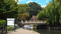
Stanstead Abbots Bridge crosses the River Lea on the B181. This is at the end of High Street, Stanstead Abbots.


Stanstead Abbots Bridge
Related Pictures
View gallery (1)
River Lee Navigation at St. Margaret's (C) Malc McDonald - Geograph - 3582766.jpg
Crossings of the River Lea (or Lee)
Luton Bridges • Airport Way Bridge • Pickford Bridge • Wheathampstead Bridge • The Watersplash • Stanborough Bridges • Stanborough Lake Bridge • Chequers Bridge • The Green Man Bypass Bridge • Holwell Bridge • Gascoyne Way Bridge • Mill Bridge • Kingsmead Viaduct • Ware Bridge • Stanstead Abbots Bridge • Stanstead Abbots Bypass Viaduct • Nazeing Bridge • Waltham Town Bridge • M25 Bridge • Lea Valley Road Bridge • Lea Valley Viaduct • Tottenham Hale Bridge • Lea Bridge • Temple Mills Bridges • Bow Flyover and Swing Bridge • A13 Barking Road Bridge • Lower Lea Crossing


SABRE - The Society for All British and Irish Road Enthusiasts
Discuss - Digest - Discover - Help