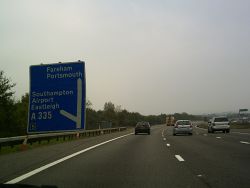
Stoneham Interchange
| Stoneham Interchange | |||
| Location Map ( geo) | |||
 | |||
| |||
| Location | |||
| Southampton | |||
| County | |||
| Hampshire | |||
| Highway Authority | |||
| National Highways | |||
| Junction Type | |||
| Roundabout Interchange | |||
| Roads Joined | |||
| M27, A335 | |||
| Junctions related to the A335 | |||
| Junctions related to the M272 | |||
Stoneham Interchange is junction 5 of the M27.
A greenfield junction where Stoneham Lane and Wide Lane were diverted to meet the new motorway. Stoneham Way, a relief road for the area, was plugged in too, a substitute for what at one point was planned to be the M272. The junction is built at a much lower level than nearby junction 4, and the land that created the embankment which the motorway and its sliproads were built on as they climb came from a nearby site which is now called Eastleigh Lakeside Country Park and is used as such by residents.
Original plans had a free-flowing junction, rather than a roundabout.
The first of three phases of widening occurred in 2009 on the south side of the roundabout, aiming to reduce queuing, although the ultimate source of it is the centre of Eastleigh and Southampton. More filter lanes and signalisation are planned.
Initially this junction was called Portswood Interchange, but that was dropped after Portswood gained its own planned motorway.
Routes
| Route | To | Notes |
| The WEST, The Docks, London, Winchester | ||
| Fareham, Portsmouth | ||
| Airport, Parkway Stn., Eastleigh | ||
| Southampton, Swaythling | ||
| Sports Ground, Chandler's Ford, Eastleigh Football Club | Stoneham Lane | |
| Error: C351 (Hampshire) does not exist | ||
| Southampton, The Docks, Car Parks, Swaythling, Portswood | ||

