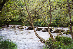
Tarr Steps
| Tarr Steps | |||
| Location Map ( geo) | |||
 | |||
| |||
| From: | Liscombe | ||
| To: | Hawkridge | ||
| Location | |||
| Exmoor | |||
| County | |||
| Somerset | |||
| Highway Authority | |||
| Exmoor National Park Error: Exmoor National Park is not a highway authority | |||
| Opening Date | |||
| 1000BC? | |||
| Additional Information | |||
| |||
| On road(s) | |||
| • unclassified | |||
Tarr Steps is perhaps one of the most famous clapper bridges in the country. Sitting deep in the Barle Valley on the southern side of Exmoor, it consists of 17 spans stretching to about 180feet, which make it the longest Clapper Bridge in the British Isles. Today, of course, the bridge is only open to pedestrians, vehicles being forced to use the ford alongside. However, beware of the height guides, as the ford can be deep enough to almost top Land Rover wheels!
Prehistoric
There are those who claim that Tarr Steps dates back as far as 1000BC, potentially making it one of the oldest bridges in the British Isles. However, while the construction type is primitive compared to even Roman designs, a date of c1400AD is seen as more realistic by many. Of course, with the at times regular flood waters found in the river, damage has often been caused over the centuries, and it could be possible that the siting of a Clapper Bridge at this location is indeed ancient, but that the current structure is comparatively modern in form.
Construction
The 17 spans are all supported by piers constructed from un-mortared piles of stones in the river. These piles are tapered, becoming narrower near the top and protected by additional stones laid against them on the slope to form primitive cutwaters, particularly on the upstream side. The bridge deck then consists of a series of large slabs resting on the piers, the largest of which is about 2.5x1.5m, weighing over a tonne. The result is that about a third of the width of the river is blocked by the stone piers, where a larger arch bridge would have a much larger proportion of the river left clear. The deck itself is too narrow for vehicles to pass, and its uneven surface made from raw stone slabs means that even pedestrians need to take care when crossing. This can be particularly relevant when the deck is wet or icy, as it can become slippery in places.
Flood Damage
It is still not uncommon for some of the slabs to become dislodged when the river is in flood, often being carried several metres downstream. To facilitate the subsequent reconstruction Exmoor National Park, who own the bridge, have now numbered all of the stones! In the past much of the damage was caused by debris becoming stuck on the structure. However, since 1952 cables across the river upstream have removed much of this danger by catching the debris before it reaches the bridge. With this in mind, it could be that the various preservation techniques employed on the structure mean that it is now 'older' than at any time in the past, when dislodged stones may have been replaced with new rather than salvaging the 'lost' stones.
| Tarr Steps | ||||
| ||||
| ||||
|

