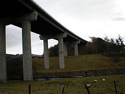
Tomatin Viaduct
| Tomatin Viaduct | |||
| Location Map ( geo) | |||
 | |||
| |||
| From: | Slochd Summit | ||
| To: | Inverness | ||
| Location | |||
| Tomatin Bypass | |||
| County | |||
| Inverness-shire | |||
| Highway Authority | |||
| Transport Scotland | |||
| Opening Date | |||
| December 1976 | |||
| Additional Information | |||
| |||
| On road(s) | |||
| A9 | |||
The Tomatin Viaduct carries the A9 across the wide valley of the River Findhorn. It sits almost next to the Findhorn Viaduct which carries the main Perth - Inverness Railway Line north, and whilst from very different eras the two seem to compliment each other.
The Viaduct itself consists of five spans, with the river under the central span. In addition, each end span has an unclassified road running under it. Four paired legs carry the steel girders that support the deck, and there are four under each of the two carriageways above.
The viaduct was built to take the busy A9 traffic away from the small village of Tomatin, and in so doing also bypassed the rather dramatic Findhorn Bridge on the old road. The bypass is shown as under construction on the 1976 OS Landranger map and opened at the end of the year.
| Tomatin Viaduct | ||||||||
| ||||||||
|


