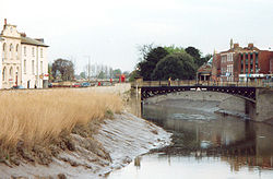
Town Bridge (Bridgwater)
| Town Bridge | |||||
| Location Map ( geo) | |||||
 | |||||
| From: | Eastover | ||||
| Location | |||||
| Bridgwater | |||||
| County | |||||
| Somerset | |||||
| Highway Authority | |||||
| Somerset | |||||
| Opening Date | |||||
| 1795, 1883 | |||||
| Additional Information | |||||
| |||||
| On road(s) | |||||
| • unclassified | |||||
For other Town Bridges, see Town Bridge.
For centuries, Bridgwater has been the main crossing point of the river Parrett, and indeed the furthest downstream since the old Roman Ferry at Combwich was abandoned. However, today it is just one of four road bridges in the town, and the one that carries the least traffic.
History
The town of Bridgwater was already known as such (or to be precise 'Walter's Bridge') in 1086 at the compilation of the Domesday Book. This suggests that the site of the town's bridge is a very ancient one. The medieval castle was built to help control the crossing, as well as the wider area, in times of unrest. However, it is not until 1795 that we get a clear idea of the type of crossing that was in place here.
In 1795, a new bridge was erected to cross the Parrett, constructed by the Darby Ironfounders of Coalbrookedale - the same foundry that had erected the Ironbridge only 20 years earlier. With ships and trade increasing in size on the Parrett, it is thought that the new bridge was built to allow larger vessels upstream, but even so trans-shipping at Bridgwater was still commonplace.
The Current Bridge
The bridge we see today is also constructed of Iron, forming a shallow arch across the river between the stone abutments. It was erected in 1883, and for over 80 years it was the towns only road bridge, carrying all of the traffic from both the A38 and A39 as it headed south and west. Obviously, with the volume of holiday traffic already using the roads in the 1960s, and with the M5 barely even a dream, this bottleneck caused horrendous problems, and so Bridgwater received its bypass, and the Blake Bridge.
The bridge appears to be wide enough to have carried three lanes of traffic (perhaps four if there were no pavements), but it is uncertain whether it ever did - can you remember?
| Town Bridge (Bridgwater) | ||||
| ||||
|

