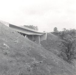
Wentbridge Viaduct
| Wentbridge Viaduct | |||||||
| Location Map ( geo) | |||||||
 | |||||||
| Wentbridge Viaduct in 1969 | |||||||
| |||||||
| From: | Went Edge Road Bridge | ||||||
| To: | Jacksons Hill | ||||||
| County | |||||||
| Yorkshire | |||||||
| Highway Authority | |||||||
| National Highways | |||||||
| Opening Date | |||||||
| 1961 | |||||||
| Additional Information | |||||||
| |||||||
| On road(s) | |||||||
| A1 | |||||||
The Wentbridge Viaduct is a high level Viaduct that carries the A1 over the valley of the River Went. It was opened as part of the 2 mile Wentbridge Bypass at the end of November 1961. It was constructed by Taylor Woodrow Construction Ltd and work had began in October 1959.
The viaduct is 470 feet long and 100 feet high. The pre-stressed concrete bridge is supported on two pairs of raking legs which have spans of over 300 feet at ground level but slope to divide the viaduct deck into a centre span of 190 feet and two side spans of 140 feet each. The legs were founded on solid mass concrete blocks taken down into sandstone rock. An unusual feature of construction was that the deck of the viaduct was well advanced before the legs were completed, a reversal of bridge building practice.
Links
