Star.pngStar.pngStar.pngStar.pngStar grey.png

Widcombe Parade

From Roader's Digest: The SABRE Wiki
Jump to navigation Jump to search
Widcombe Parade
Location Map ( geo)
Widcombe Baptist Church - Geograph - 5060884.jpg
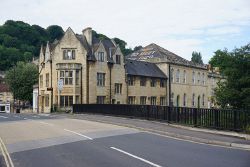
The now two way canal bridge for the A3062
Cameraicon.png View gallery (2)
Location
Widcombe, Bath
County
Somerset
Highway Authority
Bath and North East Somerset
Junction Type
complex one-way system
Roads Joined
A36, A3062
Junctions related to the A3062

Current layout

Since June 2015, Widcombe Parade in Bath has not formed part of the A36. It is now largely restored to the status of a local high street, carrying a single lane of traffic eastbound only (the opposite direction to its previous flow). The A36 now runs in both directions along the newer Rossiter Road just to the north of it. Pulteney Road South (formerly also part of the westbound A36) is now two-way, carrying the A3062. The only through traffic on Widcombe Parade is from the eastbound A36 to the A3062 and Widcombe Hill, since there is no right turn from the A36 into the A3062.

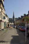
Widcombe Parade in 2008

Former layout

Before June 2015, as the A36 passed through Widcombe, just across the River Avon from Bath city centre, it became a one-way system with west bound traffic following Widcombe Parade to reach the Churchill Bridge Roundabout, and eastbound traffic using the much newer Rossiter Road.

The A3062 descended Prior Park Road to meet the A36 westbound lane at the corner of Widcombe Parade. Traffic intending to head north/east on the A36 therefore needed to follow Widcombe Parade before doubling back onto Rossiter Road at the end of the shops. Equally, traffic destined from eastbound A36 to the A3062 needed to use the right turn lane on Rossiter Road.

At almost the same point that the A3062 joined, the unclassified Widcombe Hill also met the A36. Whilst it may be unclassified, Widcombe Hill leads up to the University at Claverton Down, making it the main route for the students living in Oldfield Park and to a lesser extent Twerton. All of this combined to make this a very busy junction, with the small shopping street of Widcombe Parade itself having to cope with a substantial volume of traffic.



Widcombe Parade
Related Pictures
View gallery (2)
Claverton Street, Widcombe - Geograph - 978437.jpgWidcombe Baptist Church - Geograph - 5060884.jpg
Other nearby roads
Bath
A4 • A36 • A39 • A46 • A363 • A367 • A368 • A431 • A3039 • A3062 • A3080 • A3604 • A4016 (Bath) • B3105 • B3108 • B3110 • B3111 • B3118 • B4043 (Bath) • B4044 (Bath) • C1 (Bath and NE Somerset) • C2 (Bath and NE Somerset) • C3 (Bath and NE Somerset) • C4 (Bath and NE Somerset) • C5 (Bath and NE Somerset) • C6 (Bath and NE Somerset) • C7 (Bath and NE Somerset) • C8 (Bath and NE Somerset) • C9 (Bath and NE Somerset) • C10 (Bath and NE Somerset) • C11 (Bath and NE Somerset) • C13 (Bath and NE Somerset) • C14 (Bath and NE Somerset) • C15 (Bath and NE Somerset) • C16 (Bath and NE Somerset) • C17 (Bath and NE Somerset) • C18 (Bath and NE Somerset) • C19 (Bath and NE Somerset) • C20 (Bath and NE Somerset) • C21 (Bath and NE Somerset) • C22 (Bath and NE Somerset) • C23 (Bath and NE Somerset) • C24 (Bath and NE Somerset) • C80 (Bath and NE Somerset) • C305 (Bath and NE Somerset) • C460 (Bath and NE Somerset) • C467 (Bath and NE Somerset) • C472 (Bath and NE Somerset) • C476 (Bath and NE Somerset) • C481 (Bath and NE Somerset) • C492 (Bath and NE Somerset) • C498 (Bath and NE Somerset) • C593 (Bath and NE Somerset) • EuroVelo 2 • Fosse Way • Kelston Toll Road • NCN4 • T9 (Britain) • T39 (Britain) • T44 (Britain)
Junctions on the A36, A338 and A350
A36Redbridge Junction • Ower Interchange • Ower Roundabout • Brickworth Corner • Bourne Way Roundabout • College Roundabout • St Marks Roundabout • Castle Roundabout  • St Pauls Roundabout • Deptford Interchange • Knook • Cotley Hill Roundabout • Cley Hill Roundabout • Dead Maids  • Beckington Services Roundabout • Limpley  Stoke Viaduct • Churchill Bridge • Windsor Bridge • Twerton Fork
A338County Gates Gyratory • Bournemouth West Roundabout • Richmond Hill Roundabout • St Pauls Roundabout • Springbourne Roundabout • Cooper Dean Roundabout • Ashley Heath Roundabout • Blackwater Junction • Salisbury Road Junction • Harnham Junction • Exeter Street Roundabout • College Roundabout • Parkhouse Cross Interchange • Wickham Interchange • Tubney Wood Roundabout
A350Civic Centre Roundabout • The George Roundabout • Hunger Hill • Holes Bay Roundabout • Holes Bay North Roundabout • Upton Park Junction • Upton Roundabout • Jubilee Cross • Roundhouse Roundabout • Bailie Cross • Newton Cross • Royal Chase Roundabout • Ivy Cross Roundabout • Furzehedge Junction • Cley Hill Roundabout • Yarnbrook • Littleton Roundabout • Hampton Park • Western Way • Semington Road • Farmers Roundabout • Folly Lane • Lackham Roundabout • Rowden Roundabout • Chequers • Cepen Park South Roundabout • Bumpers Farm Roundabout • Brook Roundabout • Badger Roundabout • Malmesbury Road Roundabout • Plough Crossroads • Stanton St Quintin Roundabout


SABRE - The Society for All British and Irish Road Enthusiasts
Discuss - Digest - Discover - Help