Star.pngStar grey.pngStar grey.pngStar grey.pngStar grey.png

Winwick Interchange

From Roader's Digest: The SABRE Wiki
Jump to navigation Jump to search
Winwick Interchange
Location Map ( geo)
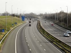
M6 Motorway, Winwick - Geograph - 2864663.jpg
Cameraicon.png View gallery (5)
Location
Winwick
County
Lancashire
Highway Authority
National Highways
Junction Type
Roundabout Interchange
Roads Joined
M6, A49, A579
Junctions related to the A579

Winwick Interchange is junction 22 of the M6. It opened in 1963, along with both the M6 and (a spur of) the A49 to the south (as the Winwick Link Road), whilst the A579 to the north opened in the early 1970's as Winwick Lane (this junction is its Southern terminus).

It is a standard non-signalised grade-separated roundabout interchange. It effectively has two lanes, however it has no lane markings around the roundabout, so is technically just one very broad lane.

It was originally intended to provide a Northern point for Warrington's traffic to access the M6 via the Winwick Link Road, however it now has relatively little traffic, as the M62's Stump Cross (and then the Croft Interchange for the M6) fulfils this role.

Routes

Route To Notes

M6

Wigan, Preston

M6

Birmingham

A579

Leigh (A572)

A49

Warrington, Newton


Winwick Interchange
Related Pictures
View gallery (5)
M6 southbound, J22 - Coppermine - 3149.jpgM6 southbound, J22 - Coppermine - 3148.jpgM6 southbound, J22 - Coppermine - 3147.jpgKenyon Way.pngA579 dogbone.jpg
Junctions on the M6
PresentM1 J19 Catthorpe • 1 Junction 1 • 2 Ansty • 3 Exhall • 3A/4 Coleshill • 4A Water Orton • 5 Castle Bromwich • 6 Gravelly Hill • 7 Great Barr • 8 Ray Hall • 9 Wednesbury • 10 Bentley • 10A Essington • 11 Laney Green • 11A Saredon • 12 Gailey • 13 Dunston • 14 Creswell • 15 Hanchurch • 16 Barthomley • 17 Sandbach • 18 Middlewich • 19 Tabley • 20 Lymm • 21 Woolston • 21A Croft • 22 Winwick • 23 Haydock Island • 24 Junction 24 • 25 Bryn • 26 Orrell • 27 Junction 27 • 28 Leyland • 29 Bamber Bridge • 30 Blacow Bridge • 31 Samlesbury • 31A Haighton • 32 Broughton • 33 Hampson Green • 34 Lune Valley • 35 Carnforth • 36 Crooklands • 37 Killington • 38 Tebay • 39 Shap • 40 Skirsgill • 41 Catterlen • 42 Golden Fleece • 43 Rosehill • 44 Kingstown • 45 Guards Mill
Former32A Broughton Roundabout • 35A Keer Level Roundabout
Unbuilt"6A" Perry Barr • "10A" Short Heath • "14A" M6 "Expressway" • "14A" M64 • "15A" M6 "Expressway" • "16A" M6 "Expressway" • "27A" Euxton • "33A" "Junction 33A"
Unenacted Extension to Glasgow"46" Gretna • "47" Kirkpatrick Fleming • "48" Eaglesfield • "49" Ecclefechan • "50" Lockerbie South • "51" Lockerbie North • "52" Johnstonebridge • "53" Beattock • "54" Elvanfoot & Crawford • "55" Abington • "56" Millbank • "57" Poniel • "58" Wellburn • "59" M74 Junction 9 • "60" Canderside Toll • "61" Larkhall • "62" Hamilton • "63" Raith • "64" Maryville • "65" Daldowie • "66" Carmyle Avenue • "67" Fullarton Road • "68" Cambuslang Road • "69" Polmadie Road • "70" Kingston
M6 TollColeshill • T1 Dunton • T2 Junction T2 • T3 Langley Mill • T4 Weeford • T5 Wall Island • T6 Brownhills  • T7 Churchbridge • T8 Wedges Mills • 11A Saredon
Junctions on the A49
Wilton Roundabout • Hope-under-Dinmore Junction • Woofferton Crossroads • Belmont Roundabout • Edgar Street Roundabout • Bayston Hill Roundabout • Preston Island • Battlefield Roundabout • Prees Heath • Ridley Junctions • Four Lane Ends • Sandybrow Crossroads • Oakmere Crossroads • Weaverham Roundabout • Dones Green Crossroads • Stretton • Owens Corner • Brian Bevan Island • Bridge Foot • St Mary's Green • Cockhedge Green • Longford Roundabout • Stump Cross • Winwick Park Roundabout • Winwick • Haydock Island • Marus Bridge Roundabout • Saddle Junction • Boar's Head • Bamber Bridge Junction


SABRE - The Society for All British and Irish Road Enthusiasts
Discuss - Digest - Discover - Help