Wisley Interchange
| Wisley Interchange | |||
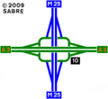
| Location Map ( geo) | |||
 | |||
| Approaching Wisley Interchange on the Anti-clockwise side of the M25 | |||
| |||
| Location | |||
| Wisley | |||
| County | |||
| Surrey | |||
| Highway Authority | |||
| National Highways | |||
| Junction Type | |||
| 3-level stacked roundabout | |||
| Roads Joined | |||
| M25, A3 | |||
The Wisley Interchange is junction 10 of the M25, with the A3. It is a 3-level stack roundabout which is currently being improved between 2023 and 2025.
This junction can sometimes be a bit of a pain. Were it not for the A245 junction the A3 has just up the road, (which hinders how far the sliproads can go) you wonder why they didn't spruce it up like the M25's better (and emptier) junction with the M23. The other problem is that the A3 drops from 3 Lanes to 2 over the M25, losing and then regaining a lane each way, which can be exceedingly annoying during the rush hour.
Another strange idea is that the A3 Southbound access slip takes ages to join the A3 carriageway. Instead, we have a mini exit for Effingham. All a bit weird...
2016 Upgrade Plan
In 2016, Highways England announced a plan for a comprehensive upgrade to the Wisley Interchange. A Public Consulation was announced in December 2016, containing two possible options:
- Option 9 - Two Semi-direct connectors from the A3 to the M25, and additional free-flow left turns
- Option 14 - Enlargement of the existing 3-level-stack roundabout to accommodate more traffic using extra lanes. Free flow left turns are also provided.
An addition option was rejected before consultation, but was still shown in the document:
- Option 16 - Cyclic interchange providing free-flow movements in every direction
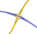
2016 Current Layout
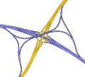
Option 9
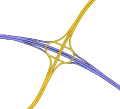
Option 14
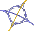
Option 16


2023-2025 Improvement
Between Summer 2023 and Summer 2025 works are taking place to improve the junction and surrounding M25 & A3. The junction itself is remaining a three stack with a middle tier roundabout, however dedicated left turn lanes would be provided in every direction & the circular carriageway to be 4 lanes wide & signalised. This is achieved by building two new bridges over the M25, and the existing bridges would be demolished. The circular carriageway would also be elongated to allow for more stacking room to increase traffic throughput. In order to achieve this, both of the Eastern M25 slip roads are required to be rebuilt to diverge and merge further away. The Western on-slip will remain the same, but the Western off-slip will be rebuilt as well. The M25 will be widened through the junction to 4 lanes, from the existing three, removing the current lane drop. Further detail is shown in the page Wisley Interchange/Improvement Project.
Strip Maps
Wisley Interchange as it is today.

Routes
| Route | To | Notes |
| Heathrow Airport, Chertsey (M3, M4, M40) | ||
| Gatwick Airport, Leatherhead, (M23, M20, M11) | ||
| London (SW), Kingston, Esher (A307) | ||
| Portsmouth, Guildford | ||
| Effingham, Hatchford, Semaphore Tower | ||
| Byfleet, Weybridge, Woking | Closed by the HA in the mid 1990s | |
| The WEST (M4), Reading, Basingstoke (M3), Woking |
Links
National Highways
- Public Consultation Document December 2016 (archive.org)
Roads.org.uk
- We Need to talk about Wisley April 2024 (archive.org)
legislation.gov.uk
- The M25 Junction 10/A3 Wisley Interchange Development Consent (Correction) Order 2023 - This Order corrects correctable errors in the M25 Junction 10/A3 Wisley Interchange Development Consent Order 2022 (S.I. 2022/549), a development consent order made under the Planning Act 2008 (c. 29), following a request under paragraph 1(5)(a) of Schedule 4 to that Act.