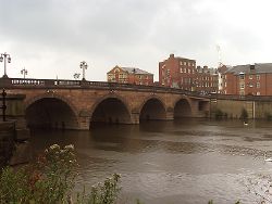
Worcester
Worcester is a Primary Destination and city in Worcestershire, of which it is the historic county town.
History
Several main routes pass through the city and this started causing congestion as car ownership grew. The first modern road improvement was a planned A38 eastern bypass in 1938. The outbreak of war a year later meant the plans were put on hold. Following the end of the war a much grander plan was promoted in the form of a motor road. This follows a route almost identical to that of the M5 which was later built.
With the main North-South traffic flow taken care of the next major bottleneck was a single bridge spanning the River Severn. All traffic travelling between east and west is funnelled across this bridge. Plans dating from 1964 show a proposed second bridge as an extension of Park Avenue. This would provide a link between the A38/A449 and A443. The junction of the A38 and A449 would become a large gyratory with St Stephens Street forming the northern section. The bridge nor gyratory were never built and all traffic still had to use Worcester Bridge as the only crossing.
In the mid 1960s a transportation study was undertaken to look into ways of solving the city's traffic problems. In 1965 the consultants recommended a network of urban motorways to distribute traffic around the city. In 1968 they produced a second report which improved many of the junctions. These proposals are shown here. By the early 1970s the city was making preparations to start building the new motorways in the arboretum area. As usual with these schemes the local community was vocal in its opposition to the destruction the new roads would bring and planning blight affected homeowners who wished to sell their properties. Some houses were bought by speculators at knock down prices. On 11th December 1972 its was reported that the entire transportation plan had been scrapped and this came as a relief to local residents which saw property values return to pre-blight values. A newspaper article at the time shows speculators were selling the houses they bought earlier and making a tidy profit on them.
A southern bypass was started in the 1980s and this provides the second bridge across the Severn the city had been wanting for some time. The bypass was later extended to the A44 to allow traffic travelling between the M5 and points west to completely avoid the city. By the early 21st century the eastern half of the bypass was seeing regular congestion. In late 2014 plans were announced to dual the busiest sections.
Routes
Several routes radiate from Worcester.
| Route | To | Notes |
| The NORTH, Birmingham | ||
| The SOUTH WEST, SOUTH WALES, Tewkesbury | ||
| Bromsgrove, Droitwich Spa | ||
| Tewkesbury | ||
| Leominster | ||
| Evesham | ||
| Stratford | ||
| Kidderminster | ||
| Malvern, Ledbury | ||
| Hereford | ||
| Ring road | The section between the A44 and A449 (alongside the M5) is non primary. | |
| Evesham | Runs between the A38 and A44 to the north of the city | |
| Hallow | ||
| Blackpole | ||
| Pershore | Former route of A44 | |
| Martley | ||
| Bilford Road | ||
| Bransford Road | Former A4103 | |
| Astwood Road | ||
| Newtown Road |
| Worcester | ||||||||
| ||||||||
| ||||||||
| ||||||||
| ||||||||
| ||||||||
|


