The study of British and Irish roads - their construction, numbering, history, mapping, past and future official roads proposals and general roads musings.
There is a separate forum for Street Furniture (traffic lights, street lights, road signs etc).
Registered users get access to other forums including discussions about other forms of transport, driving, fantasy roads and wishlists, and roads quizzes.
Yorkie wrote:...Morrison's Car Park in Hillsborough, Sheffield...
Yep, the ramp is blocked off, presumably to stop exactly this rat run. Who knows what they'll do if the right turn out onto Penistone Road is removed as part of the 'Smart Route' revamp of the whole expressway - it'll become practially impossible to get from Morrisons to the city without some major U-turnage around already chocka bits of road.
Streetview gives an excellent view of some of my favourite bonkers road-signage *ever* though... link
I routinely disobey this (much to my OH's annoyance). The route they want you to take is all the way up and around under the upper deck, across squillions of speed humps (which, incidentally, don't stop the local chavs drag racing up and down 15 feet to the left of). If they want to make bits of the car park one way then they should ruddy well use a 'no entry' sign.
parristim wrote:Streetview gives an excellent view of some of my favourite bonkers road-signage *ever* though... link
Oh god, that's awful. So so wrong! That would mean that you have an entire car park that no motorised vehicles are allowed in - those spaces look very generous even for tandems and tag-alongs!
At the point where the sections of photography join, the right hand lane of the southbound carriageway becomes the right hand lane of the northbound carriageway ... I hope that's just an error in piecing the photos together, or else there is going to be the most almighty pile-up there!
Stevie D wrote:At the point where the sections of photography join, the right hand lane of the southbound carriageway becomes the right hand lane of the northbound carriageway ... I hope that's just an error in piecing the photos together, or else there is going to be the most almighty pile-up there!
Until recently you got a brief glimpse of the M27 west after J4 with a concrete surface, this was removed in the very early 2000s.
Shows Carrington Train Station in Nottingham - closed 24 September 1928 - even the Great Central Railway which ran through it closed in 1965!
Unfortunately there are an awful lot of closed stations that are now being shown on Google Maps, and I'm struggling to find out how to get them removed or renamed to include "(Closed)" in the label. Yes, they are interesting from a historical point of view, but marking them without making it clear that they are not operational is likely to be misleading to users.
At least that station is not marked with a BR symbol, so it doesn't immediately jump out. However the use of "closed" or "site of" would be better.
B4133 wrote:I wonder if the Oldham Loop is still on there? Last time i checked was in November '09.
Yes.
Just noticed that next to the BR symbol at Nottingham (Midland) station is a link to "Nottingham railway station" - which takes you to "Nottingham Carrington Street railway station" - closed 1848 - what on earth are Google snorting? (Interestingly there is no blob on Nottingham Victoria
I think Google maps are trying to show the history of a place, with links to Wikipedia articles. The problem is that they aren't specifying whether an item they show is still current or whether it closed 50+ years ago.
Check out the map of Hanley. Marked is Hanley railway station (which closed in the 1960s and no trace of which remains) and also the Old Recreation Ground (used by Port Vale FC until 1950 and now the site of a car park - and, as it happens, marked on the wrong side of Quadrant Road!).
At least they don't use the BR logo at the station or say that the football ground is owned by a club.
"If you expect nothing from somebody you are never disappointed." - Sylvia Plath
Local businesses have recently started to be shown but the vast majority of them are in the wrong place. For example here Shell and Little Chef are on the roundabout but Google shows them some distance away.
How would you like your grade separations, Sir? Big and complex.
Truvelo wrote:Local businesses have recently started to be shown but the vast majority of them are in the wrong place. For example here Shell and Little Chef are on the roundabout but Google shows them some distance away.
Google have been incorrectly mapping businesses for years, but it's only recently that they've been showing them on the base map. In this case, the address Little Chef have given them is "Chipmans Platt, Stonehouse, Gloucestershire, GL10 3SQ". With that information Google have narrowed it down to a small area in which the restaurant could possibly be, and placed the icon randomly in that area.
Shell have given them a different post code which is why it's in a different place.
In urban areas businesses tend to supply more detailed addresses so it will be more accurate.
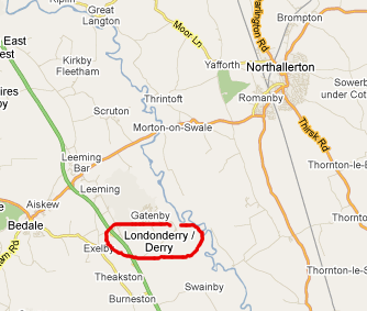
I appreciate Google trying to be sensitive to possible political fallout and not wanting to offend people by using an anachronistic colonial name instead of the preferred local name, but I think they've got the wrong end of the stick here...!
I reported a load of errors to Teleatlas over a month ago, including that one, a load of updates around Wetherby, and masses of plain old mistakes (usually showing bridleways as roads, that kind of thing). They've acknowledge receipt of them, but not done anything about them yet
Stevie D wrote:
I reported a load of errors to Teleatlas over a month ago, including that one, a load of updates around Wetherby, and masses of plain old mistakes (usually showing bridleways as roads, that kind of thing). They've acknowledge receipt of them, but not done anything about them yet
It's a long process. As they get data from the OS and then use that to create their maps. They could correct it as it stands but next time they receive an update from OS they'll have to apply those updates again if they haven't been included and it all gets rather messy.
So I guess most of the time they wait for OS to update things at their end first.