National Trails/Long Distance Paths major road crossing points
Moderator: Site Management Team

Re: National Trails/Long Distance Paths major road crossing points
I walk this section of the 'Leicestershire Round' path quite often, where you have to cross over the A46 here (southbound side) and here (northbound side).
-
Scratchwood
- Member
- Posts: 517
- Joined: Tue Jul 08, 2008 21:44
- Location: London
Re: National Trails/Long Distance Paths major road crossing points
There's another similar footbridge over the M25 near Shoreham, indeed it's quite spectacular as its higher and at the top of the hill, before the road heads down from the North DownsJim606 wrote: ↑Mon Jan 17, 2022 09:26This is the same design as the Pennine Way bridge, I wonder if it was the same architectural firm or just a standard design pattern?Scratchwood wrote: ↑Sun Jan 16, 2022 17:59 The Ridgeway crosses the A41 east of Tring using this bridge. This section of the A41 was built in the 90s
https://www.google.com/maps/@51.79073,- ... 384!8i8192
https://www.geograph.org.uk/photo/3049700
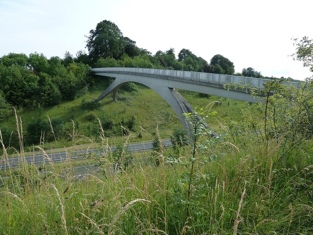
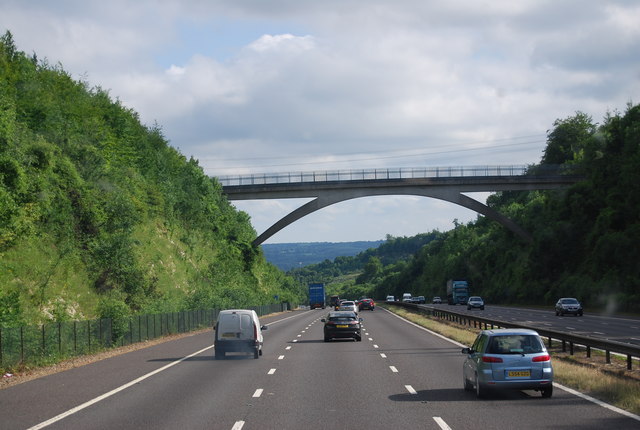
https://www.geograph.org.uk/photo/1948214

Re: National Trails/Long Distance Paths major road crossing points
Apparently the Wainwright Coast to Coast (C2C) long distance path has now gained National Trail status and a solution to crossing the A19 is being discussed. https://www.darlingtonandstocktontimes. ... -decision/
A Natural England spokesperson said: “The route approved for the Coast to Coast path crosses the A19 in the location of the existing walking route at Ingleby Arncliffe, near Northallerton. “Our preferred option, on the basis of safety and securing the line, is to build a bridge over the A19 on the existing walking route so that people can still enjoy this popular walking route safely. The next stage will focus on exploring this option with National Highways and discussing with government departments to secure funding for the crossing.”

Re: National Trails/Long Distance Paths major road crossing points
Sorry to reply to a 9-month-old post. I somehow missed this thread before.FosseWay wrote: ↑Mon Jan 17, 2022 06:22Are you saying that originally walkers had to cross the carriageway?mikehindsonevans wrote: ↑Sun Jan 16, 2022 23:24The Pennine Way M62 overbridge opened after the motorway opened. Fortunately, motorway traffic levels were FAR lower in those early far-off days.Jim606 wrote: ↑Sat Jan 15, 2022 15:36 I reckon the most famous crossing point for a National Trail/Long Distance Path must be the Pennine Way bridge across the M62... The question is what about some of the others? I know a proposed green bridge is being designed to take 'The Cotswolds Way' over the A417. Anymore for anymore?
http://happypontist.blogspot.com/2014/0 ... e-way.html
Pennine4.jpg
Traffic levels may have been lower back then, but the prohibition on pedestrians on motorways was alive and well...
I imagine walkers will have been directed under the motorway via the nearby J22 bridge.
-
Scratchwood
- Member
- Posts: 517
- Joined: Tue Jul 08, 2008 21:44
- Location: London
Re: National Trails/Long Distance Paths major road crossing points
A section of the Chiltern Way, a major regional trail, has a surface crossing of the NSL A505 between Luton and Hitchin. I found that fairly intimidating as a walker, but the path crossing the road is actually a bridleway. Taking a horse across a 70mph dual carriageway sounds really scary to me, I wonder if anyone has ever done this?
horse sign

horse sign
-
wallmeerkat
- Member
- Posts: 1320
- Joined: Fri Apr 20, 2018 16:49
- Location: County Down
Re: National Trails/Long Distance Paths major road crossing points
The Ulster Way / Lagan Towpath has an underpass under the M1 on the outskirts of Belfast
https://www.google.com/maps/@54.5395781 ... 312!8i6656
https://www.google.com/maps/@54.5395781 ... 312!8i6656

Re: National Trails/Long Distance Paths major road crossing points
No, the bridge just took longer to complete as there had been many arguments about the design of it. Pedestrians were routed via J22 and back in those earliest days. It was brought into use soon after the motorway, mind.FosseWay wrote: ↑Mon Jan 17, 2022 06:22Are you saying that originally walkers had to cross the carriageway?mikehindsonevans wrote: ↑Sun Jan 16, 2022 23:24The Pennine Way M62 overbridge opened after the motorway opened. Fortunately, motorway traffic levels were FAR lower in those early far-off days.Jim606 wrote: ↑Sat Jan 15, 2022 15:36 I reckon the most famous crossing point for a National Trail/Long Distance Path must be the Pennine Way bridge across the M62... The question is what about some of the others? I know a proposed green bridge is being designed to take 'The Cotswolds Way' over the A417. Anymore for anymore?
http://happypontist.blogspot.com/2014/0 ... e-way.html
Pennine4.jpg
Traffic levels may have been lower back then, but the prohibition on pedestrians on motorways was alive and well...
Bryn
Terminally cynical, unimpressed, and nearly Middle Age already.
She said life was like a motorway; dull, grey, and long.
Blog - https://showmeasign.online/
X - https://twitter.com/ShowMeASignBryn
YouTube - https://www.youtube.com/@BrynBuck
Terminally cynical, unimpressed, and nearly Middle Age already.
She said life was like a motorway; dull, grey, and long.
Blog - https://showmeasign.online/
X - https://twitter.com/ShowMeASignBryn
YouTube - https://www.youtube.com/@BrynBuck
Re: National Trails/Long Distance Paths major road crossing points
The crossing is between two sets of lights so traffic doesn't come in a continuous stream.Scratchwood wrote: ↑Sun Jan 16, 2022 18:18 The London LOOP (a TfL orbital path around London) crosses the A12 near Harold Wood. The official advice is to divert to the nearest traffic lights, but I imagine most walkers cross here as the road can safely be crossed in two stages
https://www.google.com/maps/@51.600259, ... 384!8i8192
Re: National Trails/Long Distance Paths major road crossing points
Icknield Way crosses the A5 Dunstable Northern Bypass on this footbridge.
https://maps.app.goo.gl/SNc9cmhMofnW5CYp9
https://maps.app.goo.gl/SNc9cmhMofnW5CYp9
Did you know there's more to SABRE than just the Forums?
Add your roads knowledge to the SABRE Wiki today!
Have you browsed SABRE Maps recently? Try getting involved!
Add your roads knowledge to the SABRE Wiki today!
Have you browsed SABRE Maps recently? Try getting involved!
-
the cheesecake man

- Member
- Posts: 2476
- Joined: Mon Jan 07, 2019 13:21
- Location: Sheffield
Re: National Trails/Long Distance Paths major road crossing points
Pennine Way crosses Snake Pass at the summit. No bridge but plenty of bleakness.
Re: National Trails/Long Distance Paths major road crossing points
Although only single carriageway, I found this crossing of the Cotswold Way and the A46 rather intimidating when I approached from the inside of the bend: https://www.google.com/maps/@51.5094941 ... 312!8i6656
It's NSL, and unless traffic is light, not a pleasant crossing. I don't think there's the budget to justify a bridge or anything though.
It's NSL, and unless traffic is light, not a pleasant crossing. I don't think there's the budget to justify a bridge or anything though.

Re: National Trails/Long Distance Paths major road crossing points
Before it was upgraded there were a number of rights of way that crossed the A1 south of Dishforth, as I recall there was a stile to help get over the Armco in the central reservation.
When the motorway was built Highfields Lane got an overbridge. Moors Lane was a farm access road and did not actually go anywhere so it was stopped off when a survey failed to showed any evidence of usage of the crossing being used.
There had at one time been a footpath just south of Moors Lane but it was clear that the RAF/MOD had closed it decades ago as it crossed part of RAF Dishforth.
https://www.google.co.uk/maps/@54.14410 ... 8192?hl=en
-
Scratchwood
- Member
- Posts: 517
- Joined: Tue Jul 08, 2008 21:44
- Location: London
Re: National Trails/Long Distance Paths major road crossing points
The Chiltern Way crosses this road a mile east of here, over this very similar bridge!darkcape wrote: ↑Fri Oct 21, 2022 13:02 Icknield Way crosses the A5 Dunstable Northern Bypass on this footbridge.
https://maps.app.goo.gl/SNc9cmhMofnW5CYp9
https://www.google.com/maps/@51.9214279 ... 384!8i8192