
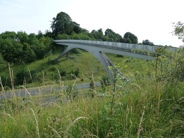
http://happypontist.blogspot.com/2014/0 ... e-way.html
- M62 Pennine Way bridge photo c/o happypontist as above
Moderator: Site Management Team


For those who'd prefer to cross the A66 by bridge, there is a detour via the Bowes Loop. Also used, I assume, by those using Bowes for an overnight stay:Big Nick wrote: ↑Sun Jan 16, 2022 01:11 This here is a great place to cross the M6 as you walk the Coast to Coast: https://goo.gl/maps/3x6MNiQscvreM8wJA
But who would like to try crossing the A19 here in the rush hour with a heavy backpack after a long days hiking?

https://goo.gl/maps/JDAooiDT2UYUawoy8
This is where the Pennine Way crosses the A66. Cracking views but good luck hopping that barrier when it's busy. https://goo.gl/maps/6XeLk71LefESWTTp7
I found this website looking at the Pennine Way crossing the A66 www.getlostmountaineering.co.uk/walks.php?id=1073 The way itself seems to cross the road directly, however, there is a underpass a little way along...This is where the Pennine Way crosses the A66. Cracking views but good luck hopping that barrier when it's busy. https://goo.gl/maps/6XeLk71LefESWTTp7
As the map below shows, the Pennine Way is routed through the subway.Jim606 wrote: ↑Sun Jan 16, 2022 11:52I found this website looking at the Pennine Way crossing the A66 www.getlostmountaineering.co.uk/walks.php?id=1073 The way itself seems to cross the road directly, however, there is a underpass a little way along...This is where the Pennine Way crosses the A66. Cracking views but good luck hopping that barrier when it's busy. https://goo.gl/maps/6XeLk71LefESWTTp7
A66 Pennine Way crossing.jpg
The Pennine Way M62 overbridge opened after the motorway opened. Fortunately, motorway traffic levels were FAR lower in those early far-off days.Jim606 wrote: ↑Sat Jan 15, 2022 15:36 I reckon the most famous crossing point for a National Trail/Long Distance Path must be the Pennine Way bridge across the M62... The question is what about some of the others? I know a proposed green bridge is being designed to take 'The Cotswolds Way' over the A417. Anymore for anymore?
http://happypontist.blogspot.com/2014/0 ... e-way.html
Pennine4.jpg

That explains why I don't remember that A66 crossing - I stayed in Bowes when I walked the Pennine Way.trickstat wrote: ↑Sun Jan 16, 2022 11:34For those who'd prefer to cross the A66 by bridge, there is a detour via the Bowes Loop. Also used, I assume, by those using Bowes for an overnight stay:Big Nick wrote: ↑Sun Jan 16, 2022 01:11 This here is a great place to cross the M6 as you walk the Coast to Coast: https://goo.gl/maps/3x6MNiQscvreM8wJA
But who would like to try crossing the A19 here in the rush hour with a heavy backpack after a long days hiking?
https://goo.gl/maps/JDAooiDT2UYUawoy8
This is where the Pennine Way crosses the A66. Cracking views but good luck hopping that barrier when it's busy. https://goo.gl/maps/6XeLk71LefESWTTp7
https://www.google.co.uk/maps/@54.51766 ... 312!8i6656
Are you saying that originally walkers had to cross the carriageway?mikehindsonevans wrote: ↑Sun Jan 16, 2022 23:24The Pennine Way M62 overbridge opened after the motorway opened. Fortunately, motorway traffic levels were FAR lower in those early far-off days.Jim606 wrote: ↑Sat Jan 15, 2022 15:36 I reckon the most famous crossing point for a National Trail/Long Distance Path must be the Pennine Way bridge across the M62... The question is what about some of the others? I know a proposed green bridge is being designed to take 'The Cotswolds Way' over the A417. Anymore for anymore?
http://happypontist.blogspot.com/2014/0 ... e-way.html
Pennine4.jpg
This is the same design as the Pennine Way bridge, I wonder if it was the same architectural firm or just a standard design pattern?Scratchwood wrote: ↑Sun Jan 16, 2022 17:59 The Ridgeway crosses the A41 east of Tring using this bridge. This section of the A41 was built in the 90s
https://www.google.com/maps/@51.79073,- ... 384!8i8192
https://www.geograph.org.uk/photo/3049700


