The study of British and Irish roads - their construction, numbering, history, mapping, past and future official roads proposals and general roads musings.
There is a separate forum for Street Furniture (traffic lights, street lights, road signs etc).
Registered users get access to other forums including discussions about other forms of transport, driving, fantasy roads and wishlists, and roads quizzes.
NICK 647063 wrote: ↑Sat Jan 22, 2022 14:09
Cullompton is fully bypassed by the M5! As it takes the through traffic away!
Traffic wanting to go to many villages between Cullompton and Exeter and even as far as the outskirts of Exeter such as Pinhoe now has to go through the town, when the Cullompton bypass was first opened before the M5, there were exits at both ends.
I get you now! A few examples on the A1(M) and examples of where a local bypass were kept too! So Wetherby, Boroughbridge and Leeming bar all had the new motorway built and access limited to one junction like cullompton but also kept a local access bypass allowing local traffic to continue to bypass the places……
Then you have catterick this is a strange one as catterick village, catterick bridge and Brompton on swale were all bypassed by the A1 with access at both ends but remained hugely busy as the A6136 didn’t have access to the bypass so came into the village then you used the old A1 to go north or south, when the A1(M) was built access was removed at both ends and just one central junction was added giving direct access to the A6136, we now have the situation where Catterick village now has the A6055 local access bypass but then the A6055 doesn’t bypass Catterick Bridge or Brompton on swale so local traffic now has to pass through….. even so traffic has halved since the new junction onto the A1(M) has removed all traffic heading to Catterick Garrison even though all local access traffic now goes through.
jabbaboy wrote: ↑Sat Jan 22, 2022 19:15
Gateshead/Newcastle centre, take your pick which.
Heading from the East to the West you could miss both via going over the Tyne Bridge then along Askew Road. Now Askew Road is buses online you either have to plow through Newcastle via the Central Station (quickest) or through Gateshead via Charles Street through the centre.
NICK 647063 wrote: ↑Sun Jan 23, 2022 21:26
Then you have catterick this is a strange one as catterick village, catterick bridge and Brompton on swale were all bypassed by the A1 with access at both ends but remained hugely busy as the A6136 didn’t have access to the bypass so came into the village then you used the old A1 to go north or south, when the A1(M) was built access was removed at both ends and just one central junction was added giving direct access to the A6136, we now have the situation where Catterick village now has the A6055 local access bypass but then the A6055 doesn’t bypass Catterick Bridge or Brompton on swale so local traffic now has to pass through….. even so traffic has halved since the new junction onto the A1(M) has removed all traffic heading to Catterick Garrison even though all local access traffic now goes through.
Catterick is now a major pain to get to, when I have to go there now I use the B roads from the A66 at Darlington through Scorton and Croft.
To get back to the original question, Wolfie mentions in his excellent book that Retford was debypassed in 1766 to boost trade from passing stagecoaches. It wasn't rebypassed until the A1 was diverted to the Doncaster A1(M) in the 1950s.
the cheesecake man wrote: ↑Mon Jan 24, 2022 13:40
To get back to the original question, Wolfie mentions in his excellent book that Retford was debypassed in 1766 to boost trade from passing stagecoaches. It wasn't rebypassed until the A1 was diverted to the Doncaster A1(M) in the 1950s.
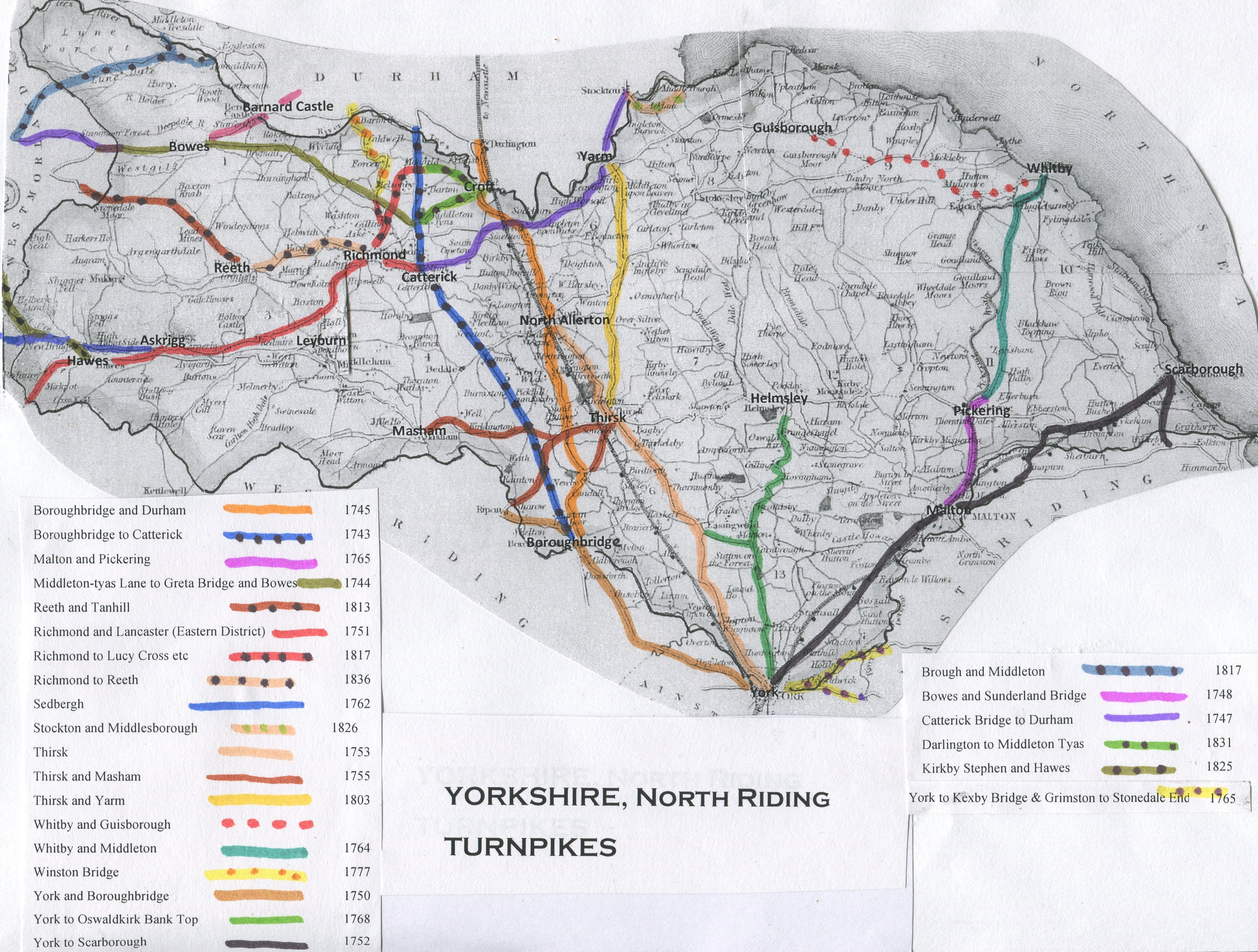
Presumably the same thing happened in Thirsk as many of the turnpikes in North Yorkshire converged there and the Market Square has more than its fair share of Coaching Inns. http://www.turnpikes.org.uk/map%20Yorks ... npikes.jpg
The town grew rapidly in the late 18th century as a result.
1740 Three Tuns Hotel established - converted from the Bell Dowager House
1754 Bull Baiting in Bull Ring outlawed
1754 Floods, washing Finkle Street bridge away – rebuilt as present
1755 Thomas Lord of Lords Cricket Ground born in Kirkgate, Thirsk
1765 First Methodist Chapel (octagonal) built on The Green
1774 Extension of Thirsk Hall completed (third centre story and wings)
1775 Thirsk Mill built, where previous Mills dating from 1143 and 1287 were
1786 Thirsk is a posting stage for coaches calling at the Three Tuns and the Fleece.
1789 Thirsk Prison demolished (inmates transferred to Northallerton)
1790 Quaker Meeting House in Kirkgate built
jabbaboy wrote: ↑Sat Jan 22, 2022 19:15
Gateshead/Newcastle centre, take your pick which.
Heading from the East to the West you could miss both via going over the Tyne Bridge then along Askew Road. Now Askew Road is buses online you either have to plow through Newcastle via the Central Station (quickest) or through Gateshead via Charles Street through the centre.
Oh definitely not, it would have been nice in road terms but the destruction it would've brought to Newcastle wouldn't outweigh the benefits.
This was more just about Askew Road which was the inner bypass of both Newcastle and Gateshead which people would use traveling say from Wallsend to Team Valley. Now it's been turned into a bus lane / cycle path so people wanting to do the same journey have to travel along S1's through Newcastle or Gateshead centre. It's pretty much jammed in Gateshead lately because of the changes.
It's the section here - https://goo.gl/maps/gRjSktwHE3UkzBp69 for anyone unaware of the area since Google Maps pretty much has it has an open road still.
Doesn't quite fit the remit but I'd chuck Loughborough into the conversation. The growth of the town outstripped the construction of the bypass/ring road, and now it's negligible as to whether you save any time whatsoever using it over the road it was bypassing. In fact, anecdotally I reckon you'd be a shade quicker striking through the heart of the town on the A6 than you would be using the A6004 during evening rush hour.
danfw194 wrote: ↑Mon Jan 24, 2022 15:59
Doesn't quite fit the remit but I'd chuck Loughborough into the conversation. The growth of the town outstripped the construction of the bypass/ring road, and now it's negligible as to whether you save any time whatsoever using it over the road it was bypassing. In fact, anecdotally I reckon you'd be a shade quicker striking through the heart of the town on the A6 than you would be using the A6004 during evening rush hour.
Especially since the town centre relief road was built so although the A6 still passes through the town it at least avoids the shopping area.
Micro The Maniac wrote: ↑Sat Jan 22, 2022 16:18
I'm tempted to nominate Bordon in Hampshire
The A325 was diverted away from the through route which was then downgraded to a C-road... but the single-carriageway relief route, with its 30 limit, several roundabouts and multiple traffic light controlled junctions is longer (both in time and distance) than just driving through the middle. Entirely as predicted in the first place.
Most of the southern section is 40 mph, it's only the top 1/3 of the bypass where it becomes a residential boulevard north of Oakhanger Road does it become 30mph. It was built to facilitate development.
The old road through the town is also being incrementally altered as it becomes more built up, so it’s already narrower than it was in several places, and is set to gain more signals, crossings, etc.
Basingstoke 'lost' its 1930s by-pass when the M3 came, though road-side house building , Cumberland Avenue probably being the first, had started soon after it's completion. topic
A significant number of towns (and one city) in Ireland had "lets re-use the single bridge" bypasses built in the 1980s and grew out to eat them. Letterkenny, New Ross, Carrick On Shannon, Limerick all come to mind.
B4444 wrote: ↑Wed Jan 26, 2022 08:49
Basingstoke 'lost' its 1930s by-pass when the M3 came, though road-side house building , Cumberland Avenue probably being the first, had started soon after it's completion. topic
Wow, I mentioned that exact place in my thread about roads that were formally major through roads but now just ordinary residential streets where it's also not obvious they were once part of major through roads.
Rochester Way, which was intended to by pass Shooters Hill and Welling in the 1920s, and became rapidly built up shortly after being built to the point traffic heading to the Medway Towns and Dover had to fight through housing estates and dodge pedestrians and parked cars. The Rochester Way Relief Rd and improvements further east couldn't come too soon and what was the A2 Rochester Way is now an unclassified road.
The demolition and removal of the eastern flank of the A4400 I.R.R. now means the eastern side of the city is now gridlocked with stationary vehicles and buses from 4 am to at least 1 am every day, causing "air quality issues" that mean people on low–paid jobs are either forced onto buses that are stationary in jams B.C.C. themselves instigated, or risking their life and limb on "sustainable transport" measures with no proper segregation from motorised traffic!
I'm afraid if I was City Mayor the CAZ would be downgraded to Class C and a scheme for full grade–separation of the A4540 and dual–carriageway improvements to the A435 and A34 would be on the cards – Sparkhill and Sparkbrook are only fit for total demolition!
There was a half by pass built to relieve the village centre of Crawcrook on the A695 in the late sixties. This was replaced by a full by pass of Ryton and Crawcrook in 1994.
Not a town but Chestnut Street on the former A249 just south of the Key street Roundabout with the A2, was by-passed when the Bobbing Hill by-pass and Key street roundabout were upgraded in the 1970's. In 1996 when the A249 was upgraded into the D2 we know today, it used the line of the 1970 by-pass of Chestnut Street, meaning that the by-passed section of road now was back carrying through traffic as a local access road between the Stockbury and Key Street roundabouts. this is evident as you head northbound on Maidstone Road from Stockbury and Danaway Street. the road goes from a wide S2 NSL road and suddenly drops in standard just before Chestnut Street into a narrow S2 as it passes through the village before widening again just prior to the Key street roundabout. This is evident on Google Earth in the 1990 image it shows the 1970 by-pass then in later images it shows the current A249 built on the line of it
Many towns with a roundabout infested S2 “bypass” will be de-bypassed in a few years, if it was even considered a bypass in the 1st place. I wonder how much money it would save to plan the new housing estates & bypasses properly.
The bedford western bypass is apparently being looked into to get dualed, and the final phase was only competed in 2016. I wonder how much more it will cost than if they just did it originally.
If MK ever gets a southern bypass i sure hope it’s an extension of the a421 or another attempt for the oxford/cambridge expressway (which i assume will eventually happen, once there’s no room for copy & pasted housing estates on the existing roads)


