Early Landrangers along the A9 corridor

Talk about items you find on SABRE Maps - interesting features, historic road layouts etc. Also contains announcements of new maps available on SABRE Maps.

Moderator: Site Management Team

Post Reply
User avatar
rileyrob
Member
Posts: 3487
Joined: Sat May 23, 2009 09:18
Location: Lochaber

Early Landrangers along the A9 corridor

Post by rileyrob »

I've just bought a pile of mostly pre1980 Landranger maps along the A9 corridor. I had to limit myself as they weren't that cheap, and some of the others available had minor changes on them, but here's some of the more important stuff. This will go onto the Wiki as necessary in due course:

21 Dornoch Firth Second Series ©1980; major roads revised 1978
A949 into Dornoch but no Dornoch Bridge. Tain Bypass under construction. A836 still crosses Struie Hill. B817 running through Invergordon but apart from some minor realignments the current A9 does not appear to have been built; certainly no Evanton/Alness bypass. Cromarty Bridge is shown but as an unclassified road.
Image

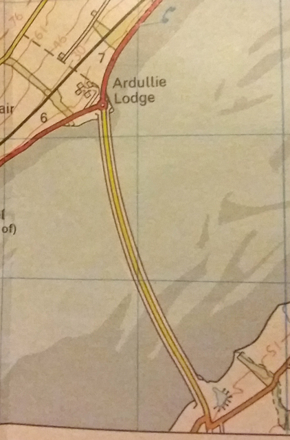
26 Inverness Landranger ©1988
A9 north of Inverness as we know it now. There was a tatty earlier sheet which showed the old A9 and current A862 routes through Dingwall all as A roads.
In Inverness, however, there are multiple un-numbered B roads shown: B9145 and B9146 routes are shown as well as the B865 (Longman Road, Inverness). Further south, the B8038 survives, but the A862 has obviously been renumbered as the B862.
The new A82 bridge over the River Ness has been built, but not connected through to the B865, so the A82 still runs through the city centre and out along the current B865, Millburn Road. There is an implied one way system around the city centre - Bank Street, Academy Street and High Street.

36 Grantown & Cairngorm Second Series ©1976; revised 1974
Old A9 route. A951 (Aviemore) following later route now used by B970 as far as Coylumbridge. A95 still runs through Dulnain and Grantown. Image
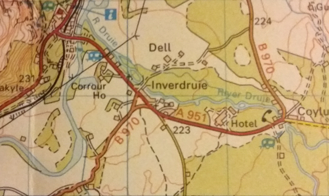
35 Kingussie Second Series ©1976; revised 1974
A862 still following what is now the B862. A9 Tomatin Bypass shown as under construction. A951 as above. Crubenmore to Dalwhinnie also shown as under construction. B970 therefore still runs through to Ralia, and does not connect to the A9 in Kingussie.

52 Pitlochry & Aberfeldy First Series ©1982
Pitlochry Bypass complete, but A924 shown as following the old A9 route south towards Ballinluig - now unclassifed. Pitnacree Bridge on the A827 is open, although there was a tatty early sheet which showed the old route still. Ballinluig is not bypassed, but Dunkeld is, along with Pass of Birnam.
At Perth, the A9 is dualled from Inveralmond to Luncarty, but there is no sign of the Perth Bypass, even though the M90 reaches Broxden. The A9 is not dualled west of Perth.

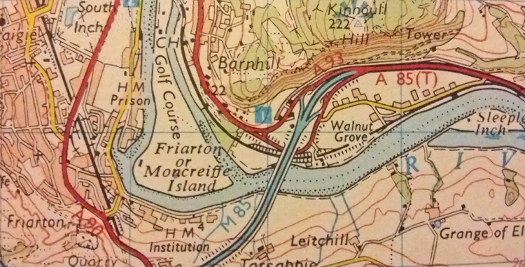
53 Blairgowrie First Series ©1980; revised 1979
Pitlochry Bypass shown as under construction. The rest of the A9 is as above. Perth is fully shown now, including the M85, but there is a curiosity here - the A93 keeps to the east bank of the Tay and meets the M85, thus forming a useless multiplex with the A85 - which continues east towards Dundee. Depsite the M90, the A90 still enters Perth.
Image

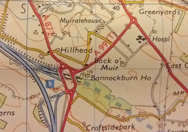
57 Stirling First Series ©1976; revised 1974
No A84 bypass at Kingshouse, Balquiddher. A892 and B8061 survive in Callander. A9 is dualled from the B8033 junction out towards Perth, but no Dunblane Bypass. The M9 Stirling Bypass and M80 are open, but the next section of the M9 is under construction. The short A99 (Stirling) is marked connecting the A9 to the motorway, but the rest of the eastern bypass is absent. A second series sheet showed The A91 crossing the Forth and reaching the A905, but the next section was under construction. The A99 label had been removed. Further west, there is no Drymen bypass.
Image

63 FIrth of Clyde First Series ©1980; revised 1978
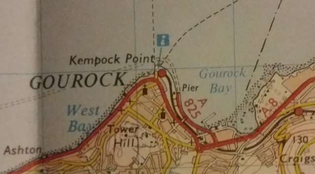
I also picked up this sheet which shows the A825 (Gourock) shown, and the A742 still runs through Greenock. Apart from a short section at Woodhall, Port Glasgow, the A8 is dualled into Greenock. The A82 Alexandria Bypass is all open with the current numbering shown. The A886 still runs along the coast - the B866 route. Further south, the A845 on Bute and A860 on Cumbrae survive, and the A78 Kilwinning Bypass is open.
Image
Rob.
My mission is to travel every road and visit every town, village and hamlet in the British Isles.
I don't like thinking about how badly I am doing.

From the SABRE Wiki: A9 :
The A9 crossing the River Spey near Kingussie


The A9 is a strategic link from the Highlands of Scotland south to the Central Belt - perhaps the most strategic link. It is certainly the highest quality route between the Central Belt and Inverness. The Scottish Government have announced proposals to dual the whole route from Perth to Inverness, and whilst a few local sections have started, commencement of work on the ground is still several

... Read More
Duncan macknight
Committee Member
Posts: 338
Joined: Thu Jul 23, 2015 10:59
Location: Inverness

Re: Early Landrangers along the A9 corridor

Post by Duncan macknight »

I’ve had a look at the 1982 Blairgowrie edition and the most interesting thing is that the Ballinluig dual carriageway was built to the north first then the bypass and junction to Kindallachan. Opened around 1983.
User avatar
rileyrob
Member
Posts: 3487
Joined: Sat May 23, 2009 09:18
Location: Lochaber

Re: Early Landrangers along the A9 corridor

Post by rileyrob »

Another interesting thing noted on the 1984? map was that the Evanton bypass was built first, with a temporary terminus at Skiach / Struie Junction and then Alness and the upgrade to the Invergordon section followed.
Rob.
My mission is to travel every road and visit every town, village and hamlet in the British Isles.
I don't like thinking about how badly I am doing.
Duncan macknight
Committee Member
Posts: 338
Joined: Thu Jul 23, 2015 10:59
Location: Inverness

Re: Early Landrangers along the A9 corridor

Post by Duncan macknight »

rileyrob wrote:Another interesting thing noted on the 1984? map was that the Evanton bypass was built first, with a temporary terminus at Skiach / Struie Junction and then Alness and the upgrade to the Invergordon section followed.
Certainly an unusual order of doing things. Could that explain the 4 1/2 mile clearway at the Struie Junction? I've discovered a 1979 Loch Rannoch OS map in my dad's shed of all places! That features the A9 Dalwhinnie Bypass to Drumochter Lodge, a small old alignment stretch to the summit and then under construction to Calvine..
User avatar
rileyrob
Member
Posts: 3487
Joined: Sat May 23, 2009 09:18
Location: Lochaber

Re: Early Landrangers along the A9 corridor

Post by rileyrob »

Following on from the OS mapping noted above, I now have a 1977 Bartholomews 4 mile map (thanks to FleetlinePhil) for NE Scotland. It shows the following:
A9 Kessock / Cromarty bridges etc all planned.
B817 through Invergordon, as on the 1978 OS sheet, but no bypasses
The old minor road from Moy Bridge to Conon Bridge is shown as the A835
Tomatin has been bypassed, with the old road an un-numbered B road
Dalwhinnie Bypass complete
Birnam - Tay Crossing at Dunkeld complete. Confusion with B898 route and also old A9 still shown as an A road.
Bankfoot Bypass under construction / planned.
Rob.
My mission is to travel every road and visit every town, village and hamlet in the British Isles.
I don't like thinking about how badly I am doing.
User avatar
owen b
Member
Posts: 9851
Joined: Sun Mar 16, 2003 15:22
Location: Luton

Re: Early Landrangers along the A9 corridor

Post by owen b »

rileyrob wrote: 21 Dornoch Firth Second Series ©1980; major roads revised 1978
A949 into Dornoch but no Dornoch Bridge.
I did a tour of Scotland in summer 1990. The Dornoch Bridge was under construction at the time. I recall seeing the bridge piers standing proud of the water but without the road across the top. The out of zone B9176 number for the Struie Hill road was not used until after the Dornoch Bridge opened.
Owen
User avatar
rileyrob
Member
Posts: 3487
Joined: Sat May 23, 2009 09:18
Location: Lochaber

Re: Early Landrangers along the A9 corridor

Post by rileyrob »

I picked up another bunch of 70s/80s Landrangers at the weekend, and while I've not had time to go through them thoroughly, the 1981 Inverness sheet has some interesting details on it.
Most notably for a map sheet dated 1981 (A/*) and with no suggestion that it had any later revisions, the A9 was shown complete across the Kessock Bridge (6/8/82) and Cromarty Bridge!
The A834 from Contin to Dingwall is shown as trunk, and then extends from the Maryburgh Roundabout down to Tore, because the section of road which is now the A835 from Contin to Maryburgh is not yet built, so as previously discussed the A834 temporarily filled the void..
Most of the short B roads in Inverness are still shown, with the A82 still going through the city centre.
The old and current routes of A roads in Dingwall Town centre are all shown.

I also picked up the 1976 Firth of Clyde sheet, which shows the Alexandria Bypass built, but suggests that the A82 still wiggles through Bonhill etc, and so is before the A811/A813 swapped, or the B857 took over the northern end of the A812 route.
Rob.
My mission is to travel every road and visit every town, village and hamlet in the British Isles.
I don't like thinking about how badly I am doing.
User avatar
Euan
Member
Posts: 1851
Joined: Mon Jan 01, 2018 07:59
Location: North Ayrshire

Re: Early Landrangers along the A9 corridor

Post by Euan »

The Queensferry Crossing was shown as being complete on many maps before it was opened, up to year before opening in some cases. However, even a year before the bridge was open progress would have been considerably underway. Similarly, the Kessock Bridge may have been in a near-complete state by the time it was shown on maps dating from 1981/82. To be honest I think publishers intend to show what new roads actually look like at the time of printing regardless of their open/closed status in the road network. I have noticed this when looking at current OS map layers of the Aberdeen bypass route, showing solid lines where the road is presumably complete or very near so and just dotted lines where more work is still in progress.
E-roads, M-roads, A-roads, N-roads, B-roads, R-roads, C-roads, L-roads, U-roads, footpaths
Duncan macknight
Committee Member
Posts: 338
Joined: Thu Jul 23, 2015 10:59
Location: Inverness

Re: Early Landrangers along the A9 corridor

Post by Duncan macknight »

rileyrob wrote: Sat Feb 10, 2018 18:37
21 Dornoch Firth Second Series ©1980; major roads revised 1978
A949 into Dornoch but no Dornoch Bridge. Tain Bypass under construction. A836 still crosses Struie Hill. B817 running through Invergordon but apart from some minor realignments the current A9 does not appear to have been built; certainly no Evanton/Alness bypass. Cromarty Bridge is shown but as an unclassified road.
Image
Was speaking to some engineers who worked on the A9 up here for on a project I'm working on. The primary reason as to why the "Arduille-Tore" bit of the A9 was unclassified was simply down to trunking reasons. If the A9 was detrunked at Dingwall and trunked via C Bridge the the A9 would need to be routed along a road from old A9 to tore which wasn't really up to standard. Plus the paperwork about tunking a road for 3years wasn't really worth it. Evanton bypass was built in 1982 and Alness 1989. By the way Were these maps purchased at Leakys in Inverness by any chance?
User avatar
rileyrob
Member
Posts: 3487
Joined: Sat May 23, 2009 09:18
Location: Lochaber

Re: Early Landrangers along the A9 corridor

Post by rileyrob »

Duncan macknight wrote: Tue Oct 23, 2018 21:43 By the way Were these maps purchased at Leakys in Inverness by any chance?
I have bought maps there, and some of those purchased in the spring came from them, but they're flipping expensive. I found some in one of the charity shops the same day.
The recent batch of maps came from the bookshops around Otago Street and the GWR in Kelvinbridge, Glasgow (2nd Photo). They were a third of the price (£1.50-2.50 for Landrangers) of those from Leakeys (£4.50+). There are also a number of good second hand bookshops in West Port, Edinburgh (£2.50-3.50).

All prices are estimates based on most recent experience! One inch sheets and Barts maps can be quite a bit more.
Rob.
My mission is to travel every road and visit every town, village and hamlet in the British Isles.
I don't like thinking about how badly I am doing.
Duncan macknight
Committee Member
Posts: 338
Joined: Thu Jul 23, 2015 10:59
Location: Inverness

Re: Early Landrangers along the A9 corridor

Post by Duncan macknight »

Got a Perth and Kinross 1983 edition. Couple of interesting points...

M90/M85 open and A85 dualled to Dundee. Perth Western Bypass not built (1986).

A9 is dualled from Broxden, then a small stretch of S2 before Windyedge straight which is dualled. Crossgates is bypassed but as a single carriageway.

Cairnie Braes not improved (1986) before becoming dualled from Auchterarder to Blackford. S2 from there to Greenloaning, then the D2 straight past Balhaldie (1960s) before passing through Dunblane (bypassed 1990) and joining with the M9.
Post Reply