I suspect that they do have additional "bits" of road that are essentially trunk, but don't form part of the "A" road or motorway network just by quirk of construction or ownership.
For example, this piece of legislation: http://www.legislation.gov.uk/uksi/2018/1404
removes trunk status from this piece of "Salford Road" https://www.google.com/maps/@52.0307545 ... 312!8i6656
The instrument implies it is part of the A421, but it isn't signed as such and wouldn't make sense to do so. I wonder if other such roads are a hangover from that sort of thing but where the new link road didn't receive an A number and was never detrunked once the scheme was complete.
It looks like some of these are as a result of HE building a bypass, re-routing the A road, renumbering the old road to ClassIII and then never transferring ownership /detrunking it - certianly the C996 White Horse Hill seems to be the pre bypass route of the A260.
The Great C Road hunt!
Moderator: Site Management Team
Re: The Great C Road hunt!
Is there a road improvement project going on near you? Help us to document it on the SABRE Wiki - help is available in the Digest forum.
Have you browsed SABRE Maps recently? Get involved! - see our guide to scanning and stitching maps
Have you browsed SABRE Maps recently? Get involved! - see our guide to scanning and stitching maps
Re: The Great C Road hunt!
The C995 is a different matter, appearing to be the access to Hopwood services from the roundabout
Is there a road improvement project going on near you? Help us to document it on the SABRE Wiki - help is available in the Digest forum.
Have you browsed SABRE Maps recently? Get involved! - see our guide to scanning and stitching maps
Have you browsed SABRE Maps recently? Get involved! - see our guide to scanning and stitching maps

Re: The Great C Road hunt!
I have just noticed an old photo on SABRE's Twitter page showing a road sign somewhere in Belfast which reads "C1" followed by "Balmoral" and "Falls". As far as I am aware there is no C1 anywhere in NI, but it looks like the known C2 (Northern Ireland) is not too far away from where this picture may have been taken so the number would not be out of place.
The actual tweet was from Bryn: https://twitter.com/ShowMeASignBryn/sta ... 1115871237
Would Bryn or anyone else know a bit more about where the picture was taken or even when it was taken? If we could find out exactly which road the sign is pointing at it would be helpful in working out if the C1 still exists or not.
E-roads, M-roads, A-roads, N-roads, B-roads, R-roads, C-roads, L-roads, U-roads, footpaths

Re: The Great C Road hunt!
It's the northbound exit from the M1 at J2 Stockmans Lane, which is now the interchange with the A55. The A55 is Belfast's Outer Ring Road and was created mostly by applying a new A-road number to existing roads, so it's safe to assume that the C1 is now the A55.Euan wrote: ↑Tue Jan 29, 2019 11:34 I have just noticed an old photo on SABRE's Twitter page showing a road sign somewhere in Belfast which reads "C1" followed by "Balmoral" and "Falls". As far as I am aware there is no C1 anywhere in NI, but it looks like the known C2 (Northern Ireland) is not too far away from where this picture may have been taken so the number would not be out of place.
The actual tweet was from Bryn: https://twitter.com/ShowMeASignBryn/sta ... 1115871237
Would Bryn or anyone else know a bit more about where the picture was taken or even when it was taken? If we could find out exactly which road the sign is pointing at it would be helpful in working out if the C1 still exists or not.
Chris
Roads.org.uk
Roads.org.uk
Re: The Great C Road hunt!
That sounds reasonable - I thought all along it would have been J2 which is clearly the best match for the place names on the sign. Looking at the road list there are one or two missing numbers within the County Down number block as well, so it is entirely possible that the A55 may also have absorbed one of these missing numbers on the other side of the city.
E-roads, M-roads, A-roads, N-roads, B-roads, R-roads, C-roads, L-roads, U-roads, footpaths

Re: The Great C Road hunt!
When the M1 was built, a junction was built at Stockman's lane. A new route, Kennedy Way was built towards Andersonstown Road and Stockman's lane to the Lisburn Road was widened. A stub Stockman's Lane still exists on the Andersonstown side, I suppose this could have still be called C1, but it was probably unclassified at some stage.Euan wrote: ↑Wed Jan 30, 2019 19:06 That sounds reasonable - I thought all along it would have been J2 which is clearly the best match for the place names on the sign. Looking at the road list there are one or two missing numbers within the County Down number block as well, so it is entirely possible that the A55 may also have absorbed one of these missing numbers on the other side of the city.
"I intend to always travel a different road"
Ibn Battuta 1304-1368
Ibn Battuta 1304-1368
Re: The Great C Road hunt!
I have now finished adding all of the County Armagh C roads to the wiki and have reached the second significant gap in the NI class III numbering system consisting of C230-C250. Armagh appears to have originally been allocated the C151-C250 range with C229 being the highest used number.
Geographically they are numbered in roughly the following order:
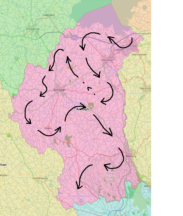
The distribution of the numbers can therefore be broken down into rough groups as follows:
 C151 - C159 - Lurgan/Craigavon
C161 - C176 - South Lough Neagh/Portadown/Tandragee
C177 - C192 - Blackwater/Armagh
C193 - C210 - Keady/Markethill/Richhill
C211 - C219 - Newtownhamilton/Newry
C220 - C227 - Slieve Guillion/borderlands
C228 - C229 - out of place, north of Newry
The only numbers out of these that do not appear to currently be in use are C190, C195 and C211. It's also possible that the numbers C228 and C229 were added later given they are slightly out of place north of Newry when the rest of the sequence runs into the county's south west corner.
Down is next.
Geographically they are numbered in roughly the following order:
The distribution of the numbers can therefore be broken down into rough groups as follows:
The only numbers out of these that do not appear to currently be in use are C190, C195 and C211. It's also possible that the numbers C228 and C229 were added later given they are slightly out of place north of Newry when the rest of the sequence runs into the county's south west corner.
Down is next.
E-roads, M-roads, A-roads, N-roads, B-roads, R-roads, C-roads, L-roads, U-roads, footpaths

Re: The Great C Road hunt!
Roads they maintain (and surely thus trunk?) that they couldn't off-hand back to local councils.
I've made pages, but haven't quite worked out what all the descriptions are referring to.
C993 (England)
C994 (England)
C995 (England)
C996 (England)
C997 (England)
C998 (England)
C999 (England)
"“Peace, commerce and honest friendship with all nations" Thomas Jefferson
From the SABRE Wiki: C993 (England) :
The C993 is Round Coppice Road between Stansted Airport and the A120-M11' [[Category:Stansted
Re: The Great C Road hunt!
That is County Down's C roads now more or less covered, although as with County Antrim perhaps with the exception of some C7xx roads within Belfast. I have now reached the third significant gap in the numbering sequence for the NI C roads which covers C380-C400 (except C388). Overall Down appears to have originally been allocated the numbers C251-C400 with C251-C379 and C388 being used up.
The geographical sequence of the numbering across the county looks roughly like this:

The distribution of the numbers can therefore be broken down into rough groups as follows:
C251 - C261 - Bangor/Ards Peninsula
C262 - C279 - Newtownards/Dundonald/Strangford Lough
C280 - C296 - Downpatrick/Lecale/Ballynahinch
C297 - C311 - Lagan Valley/SE Belfast/Dromore
C312 - C328 - Mourne Mountains/Kilkeel/Rathfriland
C329 - C342 - Warrenpoint/Newry
C343 - C355 - Banbridge
C356 - C363 - Waringsford/Moira
C364 - C379 - mixed
All of these numbers seem to be in use currently, except C301 and C372 which are unused and C264 which is defunct. There are some slight but notable exceptions to this sequence such as the C304 and the C327, but generally the pattern holds.
Interestingly, I have noticed a few cases of C2xx routes being reasonably followed on by a C3xx number within the "mixed" range such as the C369 following on from the C269 and the already mentioned C388 which follows on from the C288.
I think I am probably just over half way through adding the Northern Ireland class III roads to the wiki with three out of six counties now complete, including the two largest ones in terms of their road networks. Now onto Fermanagh...
The geographical sequence of the numbering across the county looks roughly like this:
The distribution of the numbers can therefore be broken down into rough groups as follows:
All of these numbers seem to be in use currently, except C301 and C372 which are unused and C264 which is defunct. There are some slight but notable exceptions to this sequence such as the C304 and the C327, but generally the pattern holds.
Interestingly, I have noticed a few cases of C2xx routes being reasonably followed on by a C3xx number within the "mixed" range such as the C369 following on from the C269 and the already mentioned C388 which follows on from the C288.
I think I am probably just over half way through adding the Northern Ireland class III roads to the wiki with three out of six counties now complete, including the two largest ones in terms of their road networks. Now onto Fermanagh...
E-roads, M-roads, A-roads, N-roads, B-roads, R-roads, C-roads, L-roads, U-roads, footpaths
Re: The Great C Road hunt!
Good going - the numbering sequences particularly are interesting...
Is there a road improvement project going on near you? Help us to document it on the SABRE Wiki - help is available in the Digest forum.
Have you browsed SABRE Maps recently? Get involved! - see our guide to scanning and stitching maps
Have you browsed SABRE Maps recently? Get involved! - see our guide to scanning and stitching maps
-
Micro The Maniac
- Member
- Posts: 1180
- Joined: Thu Jun 25, 2015 13:14
- Location: Gone
Re: The Great C Road hunt!
I may regret this, but I've started collating the Hampshire C roads - I've pulled the data from their database, and will run some script-foo on it.
As well as C roads, Hampshire list U (Unclassified) and W (footpaths) - I was amused to note that my home road shares the same U number as over 300 other roads/streets of the Borough
As well as C roads, Hampshire list U (Unclassified) and W (footpaths) - I was amused to note that my home road shares the same U number as over 300 other roads/streets of the Borough
From the SABRE Wiki: Hampshire Council %28Class III roads%29 :
he following is a list of Hampshire Council's Class III network 1.
| class="wikitable"
|+ Other Classified Roads
! Road !! District !! Road Names !! Comments
|-
| C1 || - || || Unused
|-
| C2 || Hart || Blackbushes Road || Between A30 and B3013
|-
| C3 || Test Valley || ||
|-
| C4 || Hart, Rushmoor || Minley Road, Farnborough and
... Cricket Hill Lane and Sandhurst Road,

Re: The Great C Road hunt!
This is the first time I've ever actually seen a C-road signposted!
I drove past it about half an hour ago (in the process of completing the NI A1 in its entirety).
I drove past it about half an hour ago (in the process of completing the NI A1 in its entirety).
Re: The Great C Road hunt!
Sprucefield offers many departures from normal principles of road design.Owain wrote: ↑Fri May 31, 2019 18:42 This is the first time I've ever actually seen a C-road signposted!
I drove past it about half an hour ago (in the process of completing the NI A1 in its entirety).
"I intend to always travel a different road"
Ibn Battuta 1304-1368
Ibn Battuta 1304-1368
-
Chris Bertram

- Member
- Posts: 15772
- Joined: Tue Nov 13, 2001 12:30
- Location: Birmingham, England
Re: The Great C Road hunt!
The former B1268 has now become C1268, according to Redcar and Cleveland Council, and is signed as such at the Four Lanes End junction with A174, formerly B1267 at that point.
“The quality of any advice anybody has to offer has to be judged against the quality of life they actually lead.” - Douglas Adams.
Did you know there's more to SABRE than just the Forums?
Add your roads knowledge to the SABRE Wiki today!
Have you browsed SABRE Maps recently? Try getting involved!
Did you know there's more to SABRE than just the Forums?
Add your roads knowledge to the SABRE Wiki today!
Have you browsed SABRE Maps recently? Try getting involved!
From the SABRE Wiki: B1268 :
The B1268 is a short B-road in north Yorkshire, now half as long as it was originally.
It starts on the A173 at Upleatham Bridge, between Guisborough and Skelton. From here it heads roughly north into Upleatham then roughly east to meet the A174 at Corngrave.
This has been the eastern end of the B1268 since 2000 when the A174 was rerouted along the
