Stoney Trail (Calgary Ring Road)

Going on holiday? Just returned with pictures or news? Found an interesting website? Post everything international in here.

Moderator: Site Management Team

User avatar
jackal
Member
Posts: 7539
Joined: Tue Jan 08, 2008 23:33
Location: M6

Stoney Trail (Calgary Ring Road)

Post by jackal »

Stoney Trail is a highway encircling 70% of Calgary, Alberta. The two final sections, in the west and southwest, are currently under construction. It's largely to D4M/eight lane standard with several complex interchanges.

Overview:
Image


West:


Southwest:
http://www.swcrrproject.com/wp-content/ ... _Final.pdf
User avatar
Truvelo
Member
Posts: 17456
Joined: Wed May 29, 2002 21:10
Location: Staffordshire
Contact:

Re: Stoney Trail (Calgary Ring Road)

Post by Truvelo »

I've been watching progress of this over the last few years. The original 1970 scheme was to upgrade the existing Trans Canada Highway through the centre of Calgary. This would have seen similarly big GSJ's in an urban area requiring large amounts of demolition.

In a way it mirrors the London Ringways where the original urban proposals were abandoned and a route around the edge was built instead. These proposals are way ahead of the M25 though. The Canucks are building their outer ring road properly instead of bodges like M25 J10.
How would you like your grade separations, Sir?
Big and complex.
User avatar
jackal
Member
Posts: 7539
Joined: Tue Jan 08, 2008 23:33
Location: M6

Re: Stoney Trail (Calgary Ring Road)

Post by jackal »

It's also remarkable how quickly it will be completed. The first section only opened in 2009, and even then had some at-grade junctions. So they'll have gone from essentially nothing to a complete 100km freeway ring road in 13 years.

In 2016 Alberta's other major city, Edmonton, completed its 78km freeway ring road, Anthony Henday Drive (Highway 216), which is similarly impressive (e.g. https://www.google.co.uk/maps/@53.56577 ... 068,15.37z and https://www.google.co.uk/maps/@53.43348 ... 403,15.37z). This is longer than the M60 (58km) and about the same as the Birmingham Box.

Certainly makes RIS2 look less like an ambitious splurge and more like bare minimum road investment.
User avatar
KeithW
Member
Posts: 19178
Joined: Thu Dec 04, 2014 13:25
Location: Marton-In-Cleveland North Yorks

Re: Stoney Trail (Calgary Ring Road)

Post by KeithW »

jackal wrote: Sat Jun 06, 2020 12:34 It's also remarkable how quickly it will be completed. The first section only opened in 2009, and even then had some at-grade junctions. So they'll have gone from essentially nothing to a complete 100km freeway ring road in 13 years.

In 2016 Alberta's other major city, Edmonton, completed its 78km freeway ring road, Anthony Henday Drive (Highway 216), which is similarly impressive (e.g. https://www.google.co.uk/maps/@53.56577 ... 068,15.37z and https://www.google.co.uk/maps/@53.43348 ... 403,15.37z). This is longer than the M60 (58km) and about the same as the Birmingham Box.

Certainly makes RIS2 look less like an ambitious splurge and more like bare minimum road investment.
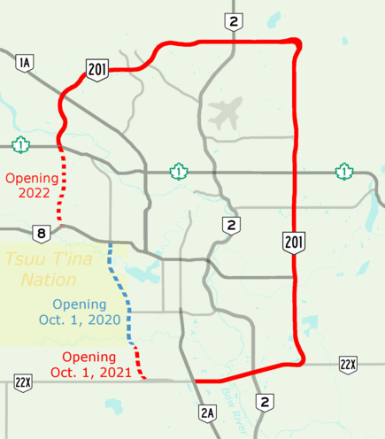
Calgary needs it, I drove through it in 2007 and it was a traffic nightmare, everywhere you looked there was new building. Its also a rather prosperous , in the last 10 years its economy grew by nearly 45% mainly driven by oil and gas from the fields up around Fort McMurray and Hydrolelectric power. Its also amazingly diverse with about 60% of the population being ethnically European, 25% Asian, 5% Black and the rest Arab and Latino. My colleague in Calgary originally hails from Toronto and his wife is Japanese. The one language you dont hear much on the streets is French :)

What is worrying locals most right now is the oil price collapse produced by the oil price war launched by Saudi Arabia, fortunately natural gas and electricity prices are still high and the Saudi's are having to back down as they are spending money faster than its being earned.
Peter Freeman
Member
Posts: 1381
Joined: Thu Aug 30, 2012 07:52
Location: Exits 9 & 10, M1 East, Melbourne, Australia

Re: Stoney Trail (Calgary Ring Road)

Post by Peter Freeman »

Very impressive! And the Edmonton one.

The detail design viewable in that enormous (!) pdf (the segment maps are easier to handle) looks somewhat Australian in parts - but on a grander scale. Many long single-lane connectors. The approaches to some dumbbell roundabouts have speed-reduction approach S-bends like ours, which would annoy the crap out of some Sabristi! There's a wide variety of complex all-movement interchanges. The width of the corridor reserved for this road is quite amazing, making the D4M look tiny in it. Also, there seems to be extravagant abandonment of previous roads on the upgrade sections, ie. not much re-use.

For two cities each of only 1.5M population, these are exciting schemes.
User avatar
KeithW
Member
Posts: 19178
Joined: Thu Dec 04, 2014 13:25
Location: Marton-In-Cleveland North Yorks

Re: Stoney Trail (Calgary Ring Road)

Post by KeithW »

Peter Freeman wrote: Wed Jun 10, 2020 16:59 Very impressive! And the Edmonton one.

The detail design viewable in that enormous (!) pdf (the segment maps are easier to handle) looks somewhat Australian in parts - but on a grander scale. Many long single-lane connectors. The approaches to some dumbbell roundabouts have speed-reduction approach S-bends like ours, which would annoy the crap out of some Sabristi! There's a wide variety of complex all-movement interchanges. The width of the corridor reserved for this road is quite amazing, making the D4M look tiny in it. Also, there seems to be extravagant abandonment of previous roads on the upgrade sections, ie. not much re-use.

For two cities each of only 1.5M population, these are exciting schemes.
Each however had a major strategic highway ploughing through it, the Trans Canada for Calgary and the Yellowhead for Edmonton and those created lots of congestion,when I drove the Alaska Highway I was advised to bypass Edmonton by leaving the highway south of Edmonton and head west until I could head north to pick 43 to Dawson Creek.
User avatar
jackal
Member
Posts: 7539
Joined: Tue Jan 08, 2008 23:33
Location: M6

Re: Stoney Trail (Calgary Ring Road)

Post by jackal »

Peter Freeman wrote: Wed Jun 10, 2020 16:59 There's a wide variety of complex all-movement interchanges.
My favourite one is at the south east limit of the scheme, with the two loops nicely folded inside the curves and the extra bridge to remove weaving. See bottom right corner here: http://www.swcrrproject.com/wp-content/ ... _Final.pdf

Conversely the interchange where it turns the corner west of there is a real stinker, with left hand entry and exit clockwise to the at-grade Highway 22X. It's a Canadian Chevening in the making.

There was a similar bodge in an earlier version of the Highway 8 interchange design (see 1:50):

The width of the corridor reserved for this road is quite amazing, making the D4M look tiny in it.
Yes, I think they've left space for at least 30 lanes through most of the SW section. It doesn't match other parts of the ring road and is vastly more than could ever be used. My hypothesis is that very wide 'medians' might sometimes make economic sense in rural Canada as an alternative to barriers, and this concept has been misapplied to the more complex scheme here (e.g., numerous bridges spanning the entire 30 lanes width, pointlessly). The province is flush with petrochemical money so no one notice the unnecessary cost.
User avatar
Truvelo
Member
Posts: 17456
Joined: Wed May 29, 2002 21:10
Location: Staffordshire
Contact:

Re: Stoney Trail (Calgary Ring Road)

Post by Truvelo »

There are some rather short weaving sections between the minor junctions. This has plagued North American freeways from day one and they are still doing it. At least we learnt the lesson early on.

As for the Highway 22X junction I would build it as a directional T instead of that long spindly single lane slip and then add some braiding to remove weaving from the exit slip to 162nd Ave.
How would you like your grade separations, Sir?
Big and complex.
Peter Freeman
Member
Posts: 1381
Joined: Thu Aug 30, 2012 07:52
Location: Exits 9 & 10, M1 East, Melbourne, Australia

Re: Stoney Trail (Calgary Ring Road)

Post by Peter Freeman »

jackal wrote: Fri Jun 12, 2020 12:11 … My hypothesis is that very wide 'medians' might sometimes make economic sense in rural Canada as an alternative to barriers, and this concept has been misapplied to the more complex scheme here (e.g., numerous bridges spanning the entire 30 lanes width, pointlessly). ...
Yes, on a smaller scale this principle was formerly applied in Australia, and occasionally still is. No barrier but a very wide grassed median. Melbourne's Eastern Freeway M3 at the city end was like that for many years, but about 15 years ago interlaced S-curved Armco's were added. Victoria's rural freeway M8 is still mainly a central-barrier-free D2M with a wide grassed median. The principle's definitely on the way out though, as Australia (Victoria at least) is currently indulging in a wire-rope barrier installation binge: median and both sides for kilometre after kilometre (of which I do approve - one element in a 'toward-zero' campaign).
Peter Freeman
Member
Posts: 1381
Joined: Thu Aug 30, 2012 07:52
Location: Exits 9 & 10, M1 East, Melbourne, Australia

Re: Stoney Trail (Calgary Ring Road)

Post by Peter Freeman »

jackal wrote: Fri Jun 12, 2020 12:11 Conversely the interchange where it turns the corner west of there is a real stinker, with left hand entry and exit clockwise to the at-grade Highway 22X. It's a Canadian Chevening in the making.
Undesirable, but I wouldn't call it a stinker - and it might become less remarkable if the '22' route is eventually upgraded and traffic flows even out a bit. I guess I'm more tolerant of wrong-side entries and exits than most. It definitely emphasises the need for good signing. I have to admit that I once took the wrong direction at Chevening anti-clockwise.
User avatar
jackal
Member
Posts: 7539
Joined: Tue Jan 08, 2008 23:33
Location: M6

Re: Stoney Trail (Calgary Ring Road)

Post by jackal »

^ They're rebuilding 3 km of Highway 22X between 37th and 69th street, but still only to at-grade D2 standard, so I don't imagine it will be grade separated any time soon. And in any case that would still be a Chevening situation (as both the A21 and M26 are grade separated).

That said, the road will be much less busy than the M25 - apparently the busiest section currently is only 80k AADT. In the short term I expect it will be fine, but given the ambition of the scheme it does stand out, as does the junction spacing as Truvelo mentions.
User avatar
Truvelo
Member
Posts: 17456
Joined: Wed May 29, 2002 21:10
Location: Staffordshire
Contact:

Re: Stoney Trail (Calgary Ring Road)

Post by Truvelo »

Canadian cities are growing at a remarkable rate with new subdivisions going up everywhere. There's also rapid growth along the Hwy 2 corridor with places like Airdrie expanding like mad. The Crossiron Mills Mall is currently surrounded by open country but will be urbanised when Airdrie and Calgary become one conurbation. All of this will pour more traffic onto the roads so they are futureproofing the ring road before it opens unlike the UK where the southwest side of the M25 was widened soon after opening due to being overwhelmed.
How would you like your grade separations, Sir?
Big and complex.
User avatar
jackal
Member
Posts: 7539
Joined: Tue Jan 08, 2008 23:33
Location: M6

Re: Stoney Trail (Calgary Ring Road)

Post by jackal »

It's interesting (though logical) that Trans Canada Highway through traffic from Medicine Hat to Banff (and vice versa) is signed to exit to the ring road, which is a lower designation and much longer but much higher standard. I also like 'BY-PASS' on the blue plate:

https://www.google.co.uk/maps/@51.06700 ... 312!8i6656
Peter Freeman
Member
Posts: 1381
Joined: Thu Aug 30, 2012 07:52
Location: Exits 9 & 10, M1 East, Melbourne, Australia

Re: Stoney Trail (Calgary Ring Road)

Post by Peter Freeman »

It's also " interesting " that some of these impressive Canadian motorways are named ' Trails ' ... !!!
booshank
Member
Posts: 610
Joined: Thu Apr 28, 2011 19:05

Re: Stoney Trail (Calgary Ring Road)

Post by booshank »

Truvelo wrote: Fri Jun 12, 2020 12:31 There are some rather short weaving sections between the minor junctions. This has plagued North American freeways from day one and they are still doing it. At least we learnt the lesson early on.

As for the Highway 22X junction I would build it as a directional T instead of that long spindly single lane slip and then add some braiding to remove weaving from the exit slip to 162nd Ave.
I drove around Calgary and south west Alberta in autumn last year. First time driving on the wrong, sorry right hand side of the road and found myself drifting into the hard shoulder at first, but it wasn't nearly as hard as I feared.

I disagree about the short weaving sections because I think it misses the point. A freeway system like Calgary's is mainly designed for travel within the city and its immediate surroundings. Britain's system is mainly designed for travel between different settlements. Each has its tradeoffs. Calgary's is that to be useful for intra city travel, the junctions have to be quite close. Britain's is that well spaced junctions are good for traffic bypassing a city but render the motorway less useful for travel within the city. I'd look for example at how the M4 and M5 near me are obviously mainly designed for bypassing Bristol or accessing the city centre via the M32 but are pretty poor at getting from one part of Bristol to another.

In short, Britain has tended to avoid short weaving sections at the cost of making its motorways much less useful for suburban use, which may be justified by having much less suburbanised cities than Canada and more inter-settlement travel due to being a more heavily populated country.
Peter Freeman
Member
Posts: 1381
Joined: Thu Aug 30, 2012 07:52
Location: Exits 9 & 10, M1 East, Melbourne, Australia

Re: Stoney Trail (Calgary Ring Road)

Post by Peter Freeman »

Truvelo wrote: Fri Jun 12, 2020 12:31 There are some rather short weaving sections between the minor junctions. This has plagued North American freeways from day one and they are still doing it. At least we learnt the lesson early on.
booshank wrote: Fri Aug 07, 2020 10:02 ... I disagree about the short weaving sections because I think it misses the point. A freeway system like Calgary's is mainly designed for travel within the city and its immediate surroundings. Britain's system is mainly designed for travel between different settlements. Each has its tradeoffs. Calgary's is that to be useful for intra city travel, the junctions have to be quite close. Britain's is that well spaced junctions are good for traffic bypassing a city but render the motorway less useful for travel within the city. I'd look for example at how the M4 and M5 near me are obviously mainly designed for bypassing Bristol or accessing the city centre via the M32 but are pretty poor at getting from one part of Bristol to another.

In short, Britain has tended to avoid short weaving sections at the cost of making its motorways much less useful for suburban use, which may be justified by having much less suburbanised cities than Canada and more inter-settlement travel due to being a more heavily populated country.
All true.

I've long held that while UK's motorways are designed primarily for intercity travel, tending to pass close to, but not through, cities, there should be more service interchanges at those close passes (and elsewhere). This would reap more benefit from the capital investment by making the motorways 'dual-purpose': inter-city and urban distribution.

I know that's an unpopular idea on Sabre, where the more frequent call has been for the closing of some interchanges (eg. on M25) in order to prevent or discourage 'junction hopping'. This would supposedly leave more space for 'strategic' traffic, but it would reduce the usefulness to short-distance urban traffic (which consists not only of car commuters, but also light commercial delivery vehicles, taxis, trades-people, emergency vehicles, etc).

I've commented on those calls before, so I won't repeat my disagreement, but I will re-make the opposite point - when two adjacent interchanges are over-capacity and their upgrade is difficult, insertion of a new interchange (or, often, a half-interchange) between them may be a better action. Yes, shorter weaving lengths, but fewer vehicles (per interchange) doing the weaving.

The incidental benefit of this, in some cases, would be the de facto addition of the urban motorway functionality.

Of course, this strategy, actioned now on long-standing and supposedly-completed motorways, would be strongly opposed by residents on the affected intermediate road. A good idea though? Especially as now, with all these years of experience after building UK's major motorways, it would be an opportunity to shift the junction inventory into more progressive territory. For example, more dumbbells and high-capacity diamonds, plus DDI's and SPUI's.
xnx
Member
Posts: 29
Joined: Sat Oct 03, 2020 03:51

Re: Stoney Trail (Calgary Ring Road)

Post by xnx »

Complete loop around Calgary opened end of last year. Mostly 3 lane and could see the 2 lane bit being widened. They are building a replacement bridge across the Bow River as the old repurposed one got worn out.

https://calgaryherald.com/news/local-ne ... -ring-road

drive in one minute (Calgary Herald):
https://www.youtube.com/watch?v=7N0kIUzu3do
User avatar
jackal
Member
Posts: 7539
Joined: Tue Jan 08, 2008 23:33
Location: M6

Re: Stoney Trail (Calgary Ring Road)

Post by jackal »

^ Thanks for that. Some interesting comments on the roads' width:
some indicated the ring road’s southwest leg had been overbuilt.

Then-NDP transportation minister Brian Mason said in 2018 his government had no choice but to honour the plan crafted by the previous PC government. He said the plan was considerably overbuilt, with the potential to contain 16 traffic lanes because of the inclusion of a 100-metre-wide median.

“My preference would be not to build it the way it is, and it’s correct to say it’s added to the cost,” Mason told Postmedia, about four years after a deal was reached with the Tsuut’ina.

On Tuesday, Dreeshen said those extra lanes will come in handy given the province’s explosive population growth.

“We’ve figured the road there will hit 100,000 vehicles a day and by 2025 we’ll likely hit that, and with the province’s growth at 100,000 people a year, we have the space to grow and add more lanes,” he said, adding lanes have recently been added to the west side of Edmonton’s ring road.
The criticism that it's wide enough for 16 lanes is pretty mild, and presumably still assumes massive medians.

You have a 100m median, plus over 40m metres for the existing D4M (including inner and outer hard shoulders). So you could fit, e.g., six D4 carriageways, each with inner and outer HS, with five medians separating them. (6*4*3.65)+(6*2*3.3)+(5*2.5)=139.7m. That would be 24 lanes even with Canadian gold-plating such as double HSs.

The idea that they'll use the space at 100k AADT or anything like that is pretty comical. The 401 in Toronto doesn't use that much space.
User avatar
ChrisH
Elected Committee Member
Posts: 3973
Joined: Wed Nov 13, 2002 11:29

Re: Stoney Trail (Calgary Ring Road)

Post by ChrisH »

jackal wrote: Fri Jan 12, 2024 12:36 ^ Thanks for that. Some interesting comments on the roads' width:
some indicated the ring road’s southwest leg had been overbuilt.

Then-NDP transportation minister Brian Mason said in 2018 his government had no choice but to honour the plan crafted by the previous PC government. He said the plan was considerably overbuilt, with the potential to contain 16 traffic lanes because of the inclusion of a 100-metre-wide median.

“My preference would be not to build it the way it is, and it’s correct to say it’s added to the cost,” Mason told Postmedia, about four years after a deal was reached with the Tsuut’ina.

On Tuesday, Dreeshen said those extra lanes will come in handy given the province’s explosive population growth.

“We’ve figured the road there will hit 100,000 vehicles a day and by 2025 we’ll likely hit that, and with the province’s growth at 100,000 people a year, we have the space to grow and add more lanes,” he said, adding lanes have recently been added to the west side of Edmonton’s ring road.
The criticism that it's wide enough for 16 lanes is pretty mild, and presumably still assumes massive medians.

You have a 100m median, plus over 40m metres for the existing D4M (including inner and outer hard shoulders). So you could fit, e.g., six D4 carriageways, each with inner and outer HS, with five medians separating them. (6*4*3.65)+(6*2*3.3)+(5*2.5)=139.7m. That would be 24 lanes even with Canadian gold-plating such as double HSs.

The idea that they'll use the space at 100k AADT or anything like that is pretty comical. The 401 in Toronto doesn't use that much space.
I would have thought it more likely that the wide median is reserved for a future pipeline, power transmission lines or freight railway. Either that or they are engaged in serious future-proofing over in Alberta!
User avatar
KeithW
Member
Posts: 19178
Joined: Thu Dec 04, 2014 13:25
Location: Marton-In-Cleveland North Yorks

Re: Stoney Trail (Calgary Ring Road)

Post by KeithW »

Calgary is one of the fastest growing cities in North America.

2001 the population was just over 870,000
2021 it reached 1.3 million

Much of this was produced by the growth of Fort McMurray where the Athabaskan tar sands are now producing huge amounts of oil which mostly goes to the USA by pipeline, rail and road.

https://www.google.com/maps/@57.0378018 ... &entry=ttu
Post Reply