UK/ROI border

The study of British and Irish roads - their construction, numbering, history, mapping, past and future official roads proposals and general roads musings.

There is a separate forum for Street Furniture (traffic lights, street lights, road signs etc).

Registered users get access to other forums including discussions about other forms of transport, driving, fantasy roads and wishlists, and roads quizzes.

Moderator: Site Management Team

Post Reply
odlum
Member
Posts: 1737
Joined: Tue Sep 12, 2006 15:07
Location: Ireland

UK/ROI border

Post by odlum »

Hi, The UK/ROI border is an intriuging place not just due to history and scenary. It is the only UK land border. The border itself is not really officially marked on the roads (ie welcome to NI - probrably would not last too long!) but it is definatley the roads themselves that leave you in no doubt what jurisdiction your in. From that point of view it must be unique in a European context. So in terms of the roads what are the noticable differences upon crossing the border?

From wiki.

- Road signs in the United Kingdom use European style red/black/white triangular roadsigns, following the Vienna Convention on Road Signs and Signals. Road signs in the Republic of Ireland are mainly American style black/yellow diamonds.

- Place-name signage in the Republic is bilingual (Irish and English), whereas UK place-name signage is (usually) English only with subtle differences in colouring and fonts.

- Differences in road markings and colour scheme used; the hard shoulder in the Republic of Ireland is marked with a yellow (usually broken) line; in the UK it is a white (usually continuous).

- All roads in Northern Ireland are named and prominently signed (in the Republic of Ireland usually only urban streets are named and signage is not standardised and can vary in clarity.)

- The road numbering systems are different: In Northern Ireland roads use A and B route prefixes, while the South's route prefixes are N and R (formerly T and L); for example, the road between Sligo and Enniskillen is known as the A4 in Northern Ireland but becomes the N16 on crossing into the Republic.

- UK postboxes are red, the Republic's are green; there are also other hints like colours/logos on telephone boxes or post offices on local roads.

- Subtle differences in road surface arising from differing technical standards for construction and materials used in roads and pavements.
Petrol stations and shops displaying prices in Sterling or euro and advertising signs at shops for lottery tickets etc.

- When travelling by car from either side the 'money changed here' signs still remain. This may change though with the immenint opening of the new A1/N1. This is important because this is the first HQDC/Motorway to cross the border.

- Since the South uses km/h instead of mph signs do tell you of the change.

Anyone here have opinions on the border roads? It is intriguing. :wink:
DorsetWay
Banned
Posts: 2021
Joined: Mon Sep 26, 2005 12:59

Post by DorsetWay »

Posted this on the "Border Uncertainity" thread - might be relevant to this thread:

Has anyone crossed the RoI/NI border on the N1/A1 road recently? I was quite shocked to see the nasty SPECS camera gantries looming over menancingly on entry into NI. What sort of impression will visitors get when entering into the UK? An OTT and control freak police state? Not a good way to enter my own country that I was actually relieved to return into the Republic in the end!
User avatar
Zoney
Member
Posts: 1252
Joined: Thu Aug 31, 2006 14:15
Location: Limerick, Ireland
Contact:

Post by Zoney »

The new N1/A1 DC crossing will surely be the first decent crossing?

The border lands are all pretty deprived rural areas with poor roads. Even up near Derry I was amazed by how rubbish the road was once out of the city. In fact, considering the roads are pretty decent for some distance in Donegal now, it's a pity the border crossing isn't good on both sides there. Although maybe the bus used the B193/R237 rather than A2/N13, but I don't think so.

The observed ROI/UK differences noted by Odlum are the main ones.

Although bizarrely Mountrath on the N7 is being bedecked with solid white line verges with the current resurfacing/traffic calming - I was tempted to email the local council, but I'm too lazy. Obviously a contractor who doesn't know better. There are a few other towns in ROI like this where a traffic-calming contractor has painted white lines on the verges by mistake.
Col2006
Member
Posts: 143
Joined: Mon Oct 30, 2006 18:40
Location: Cambridgeshire

Post by Col2006 »

Obviously the A1/N1 or N1/A1 crossing is the most significant Border road crossing, but which ones would come after it?

I would rate the N2/A5 crossing as the second most significant crossing linking Dublin and (London)derry. Who knows what will happen if the mooted motorway plans go ahead, but for a road I remember travelling on many times as a child, it has served its purpose well so far.

Then there's the N13/A2 between Derry and Letterkenny. I always wonder if reunification ever happened where the N13 would continue to - perhaps via the Skeoge link, over the Foyle Bridge and on towards Coleraine, or maybe along the Crescent Link and onwards to Belfast... with the M2 becoming M13...

Also of significant importance are the N3/A509 and A42/N3 crossings - again, would most likely become N3 on reunification (and Enniskillen gets a Western Bypass - then again that would mean an actual Road Improvement Scheme in Fermanagh!), and the N15/A15 (A5) crossing over the River Finn that separates Lifford and Strabane.

Of course, it has helped that there has been relative peace in the North that has made border crossings of a greater standard. Perhaps the lifting of border controls in 1993 would have no doubt increased the urgency to reinstate border crossings from RoI into NI, but the peace process is certainly the greater catalyst in making the various border crossings, from primary routes to unclassified roads, in a much better state than 15 years ago.

Excuse the excessive level of fantasy in this post.
odlum
Member
Posts: 1737
Joined: Tue Sep 12, 2006 15:07
Location: Ireland

Post by odlum »

Col2006 wrote:Obviously the A1/N1 or N1/A1 crossing is the most significant Border road crossing, but which ones would come after it?

I would rate the N2/A5 crossing as the second most significant crossing linking Dublin and (London)derry. Who knows what will happen if the mooted motorway plans go ahead, but for a road I remember travelling on many times as a child, it has served its purpose well so far.

Then there's the N13/A2 between Derry and Letterkenny. I always wonder if reunification ever happened where the N13 would continue to - perhaps via the Skeoge link, over the Foyle Bridge and on towards Coleraine, or maybe along the Crescent Link and onwards to Belfast... with the M2 becoming M13...

Also of significant importance are the N3/A509 and A42/N3 crossings - again, would most likely become N3 on reunification (and Enniskillen gets a Western Bypass - then again that would mean an actual Road Improvement Scheme in Fermanagh!), and the N15/A15 (A5) crossing over the River Finn that separates Lifford and Strabane.

Of course, it has helped that there has been relative peace in the North that has made border crossings of a greater standard. Perhaps the lifting of border controls in 1993 would have no doubt increased the urgency to reinstate border crossings from RoI into NI, but the peace process is certainly the greater catalyst in making the various border crossings, from primary routes to unclassified roads, in a much better state than 15 years ago.

Excuse the excessive level of fantasy in this post.
Good post.

The N2 and N3 are interesting. You would, no doubt, know about the new M3 and N2 HQDC. That means, I persume that soon enough there could be at least 2 roads of M1 standard crossing the border eventually?

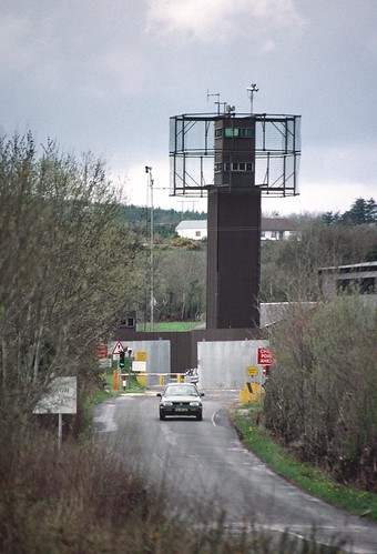
For those who dont know what some crossings looked like here is an example going from the North into Co Cavan.

Image

Thats only half of it. Youd have the Irish soldiers a bit up the road.
User avatar
Zoney
Member
Posts: 1252
Joined: Thu Aug 31, 2006 14:15
Location: Limerick, Ireland
Contact:

Post by Zoney »

Yes well, when things were bad enough that the British army was blowing up crossings for "security reasons" it's not surprising what the open crossings looked like. In fact probably the only surprising thing is that the crossing wasn't even worse!

But that is all fortunately in the past, just a few relics left at this stage, soon also to be swept away. There was an article about the planned reopening of the last couple of closed crossing points - rural roads between Monaghan/Tyrone; that'll be just more signs of the end of an era.

And in the current climate, I wouldn't expect anything other than understated crossings. We are both in the EU after all!
Col2006
Member
Posts: 143
Joined: Mon Oct 30, 2006 18:40
Location: Cambridgeshire

Post by Col2006 »

Isn't it correct that the N3 came to a dead end near the Cavan/Fermanagh border until the Troubles had ended and the Aghalane Bridge was rebuilt? I remember going on holiday when I was young, travelling via Enniskillen towards Dublin, and from what I remember, we had to travel on unclassified roads crossing the border before getting onto the N3, I think just outside Belturbet. I can't remember anything about customs that time but I am certain we had to go through British and Irish posts.

I also forgot to mention the (in)famous N54/A3/N54/A3/N54 and N51/A37 South/N51 crossings - I never travelled on those roads during the Troubles, but I am sure they were an adventure in themselves :)
Post Reply