
We were taken up by the Ranger, he must go up several times a week (if not more) but even then he hit the brakes at one point so he could reverse and try a different route.Cherskiy wrote:Yep, hitched a ride with a US Marine observer going up to a Forward Air Control exercise at Faraid Head a few years back - vehicles drive across the beach at Balnakeil Bay first, then join the road (so another section of road not joined up to the network!) at the other end - said road then disappearing under the dunes as you say, for a good long stretch a bit further on.J--M--B wrote:If you think that is bad then you should try a ride up to the Range Control near Durness. The road disappeared under the sand years ago so it seems to be a different route every day as the sand moves around.
I've seen photos of the minibus going across the Kyle on the pontoon - a grand name for a couple of planks of wood lashed to some large plastic drums!
One of these days I'll have to take some shots of the road network on the Otterburn Ranges.
U70 Road To Cape Wrath - NW Scotland - Pictures
Moderator: Site Management Team
Re: U70 Road To Cape Wrath - NW Scotland - Pictures
JMB
Fort William
http://www.mbriscoe.me.uk
"Give me the third best technology. The second best won't be ready in time. The best will never be ready." Robert Watson-Watt
Fort William
http://www.mbriscoe.me.uk
"Give me the third best technology. The second best won't be ready in time. The best will never be ready." Robert Watson-Watt
-
gannman
- Member
- Posts: 18
- Joined: Thu Jul 10, 2008 17:58
- Location: Glen Burnie, Maryland, USA
- Contact:
Re: U70 Road To Cape Wrath - NW Scotland - Pictures
Indeed it does look like a bridge crossing - until you turn off the Roads. Also, look for little bitty icons at each side of the "bridge". If you click on them, a little message balloon pops up saying something like "Kyle of Durness Ferry Landing".Nwallace wrote:nowster wrote:Google Maps has the ferry link as a bridge.
Appears to be another Classic Teleatlas pile of pishness.
Multimap show a bridge as well in Teleatlas mode.
Best thing MS have done is add the Colins-Barts road mapping to supplement the OS 1:50k
"Changes" can be reported to Teleatlas using the following link
http://navigation.teleatlas.com/en/improvement/

Re: U70 Road To Cape Wrath - NW Scotland - Pictures
I took a trip to Cape Wrath last week and went on the minibus tour. The road is now more of a track and very bumpy with lots of potholes. I don't think it has been maintained for at least 50 years. As a result the bus never made it beyond 2nd gear and was struggling to exceed 10mph at the best of times. It definitely made the trip very amusing and unique. We had a trainee bus driver who was being helped by a more experienced guy and they were running a commentary together.
As a road enthusiast, I was amazed when the more senior tour guide mentioned that the road was called the U70 (he even joked that the U stood for useless!). This prompted me to do a bit of reading up on the U roads of the Highland region. I am aware that in 2007 all of the C roads and U roads in the region were renumbered and given 4-digit numbers in order to be uniquely identified by the council. The old system was based on historic counties and so there were many duplicates within the council's jurisdiction (i.e. U1 in Sutherland, U1 in Inverness-shire etc...). My assumption that the U70 was an old Sutherland-based number was confirmed after checking the council's road list. As it turns out, under the new system the Cape Wrath "road" is numbered U1278. I do find it surprising that the road was given a number at all considering the fact that nobody lives there and there is no vehicle access from the other side.
Overall a great trip! I would certainly recommend it if you have a few hours while touring the far north of Scotland. I just wonder how often they have to replace those tyres...
E-roads, M-roads, A-roads, N-roads, B-roads, R-roads, C-roads, L-roads, U-roads, footpaths
-
ScottB5411

- Member
- Posts: 4153
- Joined: Wed Jun 16, 2010 20:04
- Location: St. Louis, Missouri, USA
Re: U70 Road To Cape Wrath - NW Scotland - Pictures
Feel free to add it to the wiki!!
Wonder if that guide is one of our members then
Wonder if that guide is one of our members then
How about some more beans Mr. Taggart?
Re: U70 Road To Cape Wrath - NW Scotland - Pictures
Plenty of commercial bow loaders going around that would take an HGV on payment.Nicholas wrote:A great set of photos! How on earth would a HGV use that road?!?!
Is the café at the cape shut then?No one lives there
Last edited by Nwallace on Mon Apr 16, 2018 20:58, edited 1 time in total.
Re: U70 Road To Cape Wrath - NW Scotland - Pictures
YouTube: Otterburn InCar gets you a fewCherskiy wrote: One of these days I'll have to take some shots of the road network on the Otterburn Ranges.
https://www.youtube.com/watch?v=RlSqY2Pzbws
-
Glen

- Social Media Admin
- Posts: 5432
- Joined: Mon Mar 13, 2006 02:16
- Location: Inbhir Pheofharain
- Contact:
Re: U70 Road To Cape Wrath - NW Scotland - Pictures
It's an adopted road, IE maintained at the public expense, therefore like all adopted roads, has a number to identify it.Euan wrote:As it turns out, under the new system the Cape Wrath "road" is numbered U1278. I do find it surprising that the road was given a number at all considering the fact that nobody lives there and there is no vehicle access from the other side.
-
trencheel303

- Account deactivated at user request
- Posts: 257
- Joined: Wed Jun 11, 2014 20:24
- Location: England
Re: U70 Road To Cape Wrath - NW Scotland - Pictures
Fascinating. I’ve pondered over going up there.
I thought ardnamurchan (particularly the parts like portuairk) were quiet, this definitely trumps it.
I thought ardnamurchan (particularly the parts like portuairk) were quiet, this definitely trumps it.
Re: U70 Road To Cape Wrath - NW Scotland - Pictures
The Ozone Cafe at the Cape is still open; John Ure and his wife who run it (and live there at least in the spring/summer/early autumn) keep a car both sides of the Kyle; I got the ferry over with John on 23 April this year when he was transporting stock over from 'the mainland'; and as at that date there were at least three ageing minibuses on the Cape Wrath side of the ferry. According to a display at the cafe, there were complaints about the state of the U70 road as far back as the early 1930s when there was presumably a regular vehicle ferry as tourists were able to hire a car in Durness for 25/- a day in order to drive to the Cape, and cars tended to come back a little the worse for wear - which must mean that there has been no significant maintenance done to the road since the 1920s, apart from building the bridge at Daill to replace the earlier ford. I assume that military vehicles using the road (and the branches to Kearvaig bothy and the jetty at Clais Charnach) are helicoptered in. The road has milestones (every mile) showing the distance to the Cape; at first sight it's a little strange that, at the ferry slipway at Keoldale, with half a mile of water ahead of you, you are confronted with signs warning of a 7-foot width limit and a weak bridge with a 7.5T weight limit - but they relate to the bridge at Daill two miles beyond the ferry and are there to warn off anyone who might attempt to take an HGV over the water.
.
Re: U70 Road To Cape Wrath - NW Scotland - Pictures
A bit more info from the Wikipedia article on Achiemore, the former village just south of the bridge at Daill on the U70. The road was built in the 1830s to provide access to the lighthouse at the Cape; the earlier track used a slipway north of Daill. The bridge at Daill, replacing the ford, was built by Royal Marines in 1980.alderroad wrote: ↑Mon Jun 27, 2022 17:30The Ozone Cafe at the Cape is still open; John Ure and his wife who run it (and live there at least in the spring/summer/early autumn) keep a car both sides of the Kyle; I got the ferry over with John on 23 April this year when he was transporting stock over from 'the mainland'; and as at that date there were at least three ageing minibuses on the Cape Wrath side of the ferry. According to a display at the cafe, there were complaints about the state of the U70 road as far back as the early 1930s when there was presumably a regular vehicle ferry as tourists were able to hire a car in Durness for 25/- a day in order to drive to the Cape, and cars tended to come back a little the worse for wear - which must mean that there has been no significant maintenance done to the road since the 1920s, apart from building the bridge at Daill to replace the earlier ford. I assume that military vehicles using the road (and the branches to Kearvaig bothy and the jetty at Clais Charnach) are helicoptered in. The road has milestones (every mile) showing the distance to the Cape; at first sight it's a little strange that, at the ferry slipway at Keoldale, with half a mile of water ahead of you, you are confronted with signs warning of a 7-foot width limit and a weak bridge with a 7.5T weight limit - but they relate to the bridge at Daill two miles beyond the ferry and are there to warn off anyone who might attempt to take an HGV over the water.
.
Re: U70 Road To Cape Wrath - NW Scotland - Pictures
If you visit https://durness.wixsite.com/durnessnew/ ... -durness-3 you'll see photos of a minibus beingcarried across the Kylealderroad wrote: ↑Mon Jun 27, 2022 17:51A bit more info from the Wikipedia article on Achiemore, the former village just south of the bridge at Daill on the U70. The road was built in the 1830s to provide access to the lighthouse at the Cape; the earlier track used a slipway north of Daill. The bridge at Daill, replacing the ford, was built by Royal Marines in 1980.alderroad wrote: ↑Mon Jun 27, 2022 17:30The Ozone Cafe at the Cape is still open; John Ure and his wife who run it (and live there at least in the spring/summer/early autumn) keep a car both sides of the Kyle; I got the ferry over with John on 23 April this year when he was transporting stock over from 'the mainland'; and as at that date there were at least three ageing minibuses on the Cape Wrath side of the ferry. According to a display at the cafe, there were complaints about the state of the U70 road as far back as the early 1930s when there was presumably a regular vehicle ferry as tourists were able to hire a car in Durness for 25/- a day in order to drive to the Cape, and cars tended to come back a little the worse for wear - which must mean that there has been no significant maintenance done to the road since the 1920s, apart from building the bridge at Daill to replace the earlier ford. I assume that military vehicles using the road (and the branches to Kearvaig bothy and the jetty at Clais Charnach) are helicoptered in. The road has milestones (every mile) showing the distance to the Cape; at first sight it's a little strange that, at the ferry slipway at Keoldale, with half a mile of water ahead of you, you are confronted with signs warning of a 7-foot width limit and a weak bridge with a 7.5T weight limit - but they relate to the bridge at Daill two miles beyond the ferry and are there to warn off anyone who might attempt to take an HGV over the water.
.
Re: U70 Road To Cape Wrath - NW Scotland - Pictures
If you visit https://durness.wixsite.com/durnessnew/ ... -durness-3 you'll see photos of a minibus being carried across the Kyle on a raft.alderroad wrote: ↑Mon Jun 27, 2022 17:51A bit more info from the Wikipedia article on Achiemore, the former village just south of the bridge at Daill on the U70. The road was built in the 1830s to provide access to the lighthouse at the Cape; the earlier track used a slipway north of Daill. The bridge at Daill, replacing the ford, was built by Royal Marines in 1980.alderroad wrote: ↑Mon Jun 27, 2022 17:30The Ozone Cafe at the Cape is still open; John Ure and his wife who run it (and live there at least in the spring/summer/early autumn) keep a car both sides of the Kyle; I got the ferry over with John on 23 April this year when he was transporting stock over from 'the mainland'; and as at that date there were at least three ageing minibuses on the Cape Wrath side of the ferry. According to a display at the cafe, there were complaints about the state of the U70 road as far back as the early 1930s when there was presumably a regular vehicle ferry as tourists were able to hire a car in Durness for 25/- a day in order to drive to the Cape, and cars tended to come back a little the worse for wear - which must mean that there has been no significant maintenance done to the road since the 1920s, apart from building the bridge at Daill to replace the earlier ford. I assume that military vehicles using the road (and the branches to Kearvaig bothy and the jetty at Clais Charnach) are helicoptered in. The road has milestones (every mile) showing the distance to the Cape; at first sight it's a little strange that, at the ferry slipway at Keoldale, with half a mile of water ahead of you, you are confronted with signs warning of a 7-foot width limit and a weak bridge with a 7.5T weight limit - but they relate to the bridge at Daill two miles beyond the ferry and are there to warn off anyone who might attempt to take an HGV over the water.
.
-
Was92now625

- Member
- Posts: 848
- Joined: Fri Jan 08, 2010 00:29
- Location: near A625
Re: U70 Road To Cape Wrath - NW Scotland - Pictures
1988 when I went there.
When you get to the lighthouse, look for the sundial with one of the steepest gnomons on the UK mainland !
Back in/near Durness, also visit Smoo Cave.
When you get to the lighthouse, look for the sundial with one of the steepest gnomons on the UK mainland !
Back in/near Durness, also visit Smoo Cave.

Re: U70 Road To Cape Wrath - NW Scotland - Pictures
I made it up here in May 2019 and despite the weather it was worth the torturous bumpy ride along the old road. The Ozone Cafe was good. Here's a few of my pics.
Me at Cape Wrath lighthouse!

We drove up in the 'nice' bus. You can see the road is single track and has only been repaired where the wheels hit.
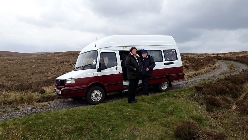
This was the alternative minibus.

There was always this.... we could see daylight thru the panels!
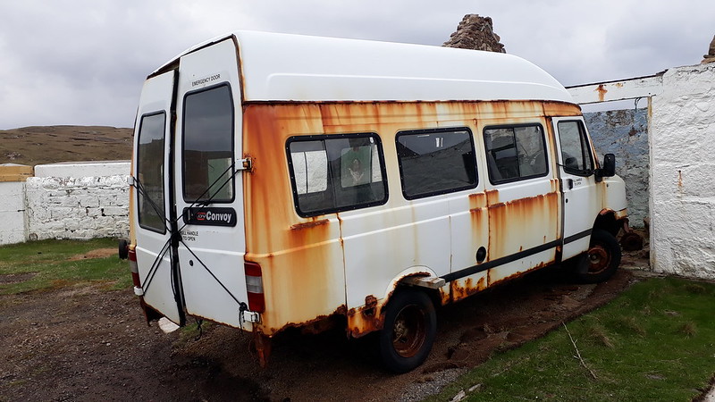

The obligatory vehicle scrapyard

Blown away road sign of the active military presence

Kearvaig Bridge

Last of the mile markers, this at the Durness end by Ferry House

Smoo Cave and Durness. Lots of ex-military buildings around here.

John Lennon came here many times on holiday to see his family. He famously drove his white Austin Maxi into a ditch on the way here in 1969.

Me at Cape Wrath lighthouse!
We drove up in the 'nice' bus. You can see the road is single track and has only been repaired where the wheels hit.
This was the alternative minibus.
There was always this.... we could see daylight thru the panels!
The obligatory vehicle scrapyard
Blown away road sign of the active military presence
Kearvaig Bridge
Last of the mile markers, this at the Durness end by Ferry House
Smoo Cave and Durness. Lots of ex-military buildings around here.
John Lennon came here many times on holiday to see his family. He famously drove his white Austin Maxi into a ditch on the way here in 1969.