The study of British and Irish roads - their construction, numbering, history, mapping, past and future official roads proposals and general roads musings.
There is a separate forum for Street Furniture (traffic lights, street lights, road signs etc).
Registered users get access to other forums including discussions about other forms of transport, driving, fantasy roads and wishlists, and roads quizzes.
RJDG14 wrote: ↑Tue Aug 27, 2019 00:50
it would make more sense to renumber the existing M22 M2 and rename the Ballymena Bypass the M22?
Probably M26 would make more sense if you were trying to renumber things logically. Although, further up the thread (or maybe on another thread) the rhetorical* question was posed as to if you were going to renumber in NI, where would you stop.
* I'm sure there are threads already for NI renumbering or all ireland numbering, so further discussion would be best off there...
This is my amended version of that NI road map, showing all major all-purpose dual carriageways which/are have since been constructed on the approximate line of the proposed motorways (solid red), high quality dual carriageways which have/are since been constructed where no motorway was originally proposed (dashed red), and sections of proposed motorway where the equivalent road is still S2 (black). I accidentally forgot the Westway, which should be red.
RJDG14 wrote: ↑Tue Aug 27, 2019 13:53
This is my amended version of that NI road map, showing all major all-purpose dual carriageways which/are have since been constructed on the approximate line of the proposed motorways (solid red), high quality dual carriageways which have/are since been constructed where no motorway was originally proposed (dashed red), and sections of proposed motorway where the equivalent road is still S2 (black). I accidentally forgot the Westway, which should be red.
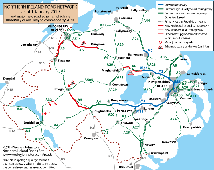
There's a full network map on Wesley's site which is up to date:
RJDG14 wrote: ↑Tue Aug 27, 2019 00:50
it would make more sense to renumber the existing M22 M2 and rename the Ballymena Bypass the M22?
Probably M26 would make more sense if you were trying to renumber things logically. Although, further up the thread (or maybe on another thread) the rhetorical* question was posed as to if you were going to renumber in NI, where would you stop.
* I'm sure there are threads already for NI renumbering or all ireland numbering, so further discussion would be best off there...
The A26 from Antrim to Coleraine should be the A9, and the M2 Ballymena bypass should be M9!
Does Northern Ireland have a locational numbering structure for all-purpose roads like the Republic, England, Wales and Scotland do, or is it like the Isle of Man where they are simply named strategically without any pattern? I think the latter.
I was also unaware that they're planning to commence work on dualling the A5 in the next year. When I was in Northern Ireland 2 weeks ago there were no signs of any dualling work along any distance of the A5. It may be possible that they are delaying the work until after Brexit is delivered in case it results in a hard border, since the A5 bypasses Strabane which is only about 1 mile from it, and it may affect junction designs there.
Last edited by RJDG14 on Tue Aug 27, 2019 15:49, edited 1 time in total.
RJDG14 wrote: ↑Tue Aug 27, 2019 15:43
Does Northern Ireland have a locational numbering structure for all-purpose roads like the Republic, England, Wales and Scotland do, or is it like the Isle of Man where they are simply named strategically without any pattern? I think the latter.
There is a very rough clockwise order to numbering from A1 to A6, but A7 and A8 buck that trend and A9 was never allocated. There were never any roads numbered A10-A19 either, until the recent (but hardly signed and therefore pointless) A11 and the A12 in Belfast. Then, from A20 to A49, it looks like the people in charge just worked their way around the map, starting in Belfast east of the Lagan and proceeding around the province in a clockwise direction several times over.
I'd say that there is more of a recognisable pattern to road numbers in NI than on the Isle of Man.
To my knowledge Northern Ireland is also the only place in the UK that has single and double digit B-roads. The Northern Irish A2 must be one of the most mixed-standard sections of road in the whole of the UK, with some of it being near-motorway standard while other sections are barely B-road standard.
While I was there a couple of weeks ago my dad had a minor accident on the Sydenham Bypass when he hit a curb at 40mph and punctured his front-left tyre, so we had to wait on the hard shoulder for a little over an hour (luckily it was a nice day) for a van to arrive and replace it, which only took about 5 minutes. He'd had some issues with his tyre pressure the previous week when driving around Harrogate, so I suspect his tyres may have been weak as they hadn't been replaced since he got his car 4 years ago (he drives a round trip of 140 miles most days to and from work).
Last edited by RJDG14 on Tue Aug 27, 2019 16:00, edited 1 time in total.
RJDG14 wrote: ↑Tue Aug 27, 2019 15:43
Does Northern Ireland have a locational numbering structure for all-purpose roads like the Republic, England, Wales and Scotland do, or is it like the Isle of Man where they are simply named strategically without any pattern? I think the latter.
There is a very rough clockwise order to numbering from A1 to A6, but A7 and A8 buck that trend and A9 was never allocated. There were never any roads numbered A10-A19 either, until the recent (but hardly signed and therefore pointless) A11 and the A12 in Belfast. Then, from A20 to A49, it looks like the people in charge just worked their way around the map, starting in Belfast east of the Lagan and proceeding around the province in a clockwise direction several times over.
I'd say that there is more of a recognisable pattern to road numbers in NI than on the Isle of Man.
To my knowledge Northern Ireland is also the only place in the UK that has single and double digit B-roads. The Northern Irish A2 must be one of the most mixed-standard sections of road in the whole of the UK, with some of it being near-motorway standard while other sections are barely B-road standard.
I'm going over there at the end of this week! ... Hoping to drive the new dualled A6, as well as completing the A2 (which I've done from 'derry to Bangor and from Strangford to Newry.
RJDG14 wrote: ↑Tue Aug 27, 2019 15:43
Does Northern Ireland have a locational numbering structure for all-purpose roads like the Republic, England, Wales and Scotland do, or is it like the Isle of Man where they are simply named strategically without any pattern? I think the latter.
If you think you understand NI road numbering then you probably haven't looked at it carefully.
While A6/A5 improvements are very welcome, they'd also need to get cracking on the A1 Junction improvements as this is a busy and dangerous road.
"I intend to always travel a different road"
Ibn Battuta 1304-1368
There is a very rough clockwise order to numbering from A1 to A6, but A7 and A8 buck that trend and A9 was never allocated. There were never any roads numbered A10-A19 either, until the recent (but hardly signed and therefore pointless) A11 and the A12 in Belfast. Then, from A20 to A49, it looks like the people in charge just worked their way around the map, starting in Belfast east of the Lagan and proceeding around the province in a clockwise direction several times over.
I'd say that there is more of a recognisable pattern to road numbers in NI than on the Isle of Man.
To my knowledge Northern Ireland is also the only place in the UK that has single and double digit B-roads. The Northern Irish A2 must be one of the most mixed-standard sections of road in the whole of the UK, with some of it being near-motorway standard while other sections are barely B-road standard.
I'm going over there at the end of this week! ... Hoping to drive the new dualled A6, as well as completing the A2 (which I've done from 'derry to Bangor and from Strangford to Newry.
This is what the new A6 looked like on my trip the other week:
The Toome bypass was dualled about 15 years ago (according to my parents they remember driving along it the first time they went together to see my Northern Irish grandad in 1998, but this looks to be a false memory and they may have been confusing it with a time when I was small), but is a similar standard apart for a couple of at-grade junctions, and the section between Toome and Castledawson is still in the process of being dualled, though the on-line sections definitely look as though they're nearing completion. The new road between Toome and Randalstown felt as though it pretty much halves the distance time from what it was on the old road.
Last edited by RJDG14 on Tue Aug 27, 2019 16:35, edited 1 time in total.
Owain wrote: ↑Tue Aug 27, 2019 15:56I'm going over there at the end of this week! ... Hoping to drive the new dualled A6, as well as completing the A2 (which I've done from 'derry to Bangor and from Strangford to Newry.
This is what the new A6 looked like on my trip the other week:
A6NewSection.jpg
The Toome bypass was dualled about 15 years ago (according to my parents they remember driving along it the first time they went together to see my Northern Irish grandad in 1998, but this looks to be a false memory and they may have been confusing it with a time when I was small), but is a similar standard apart for a couple of at-grade junctions, and the section between Toome and Castledawson is still in the process of being dualled, though the on-line sections definitely look as though they're nearing completion. The new road between Toome and Randalstown felt as though it pretty much halves the distance time from what it was on the old road.
I have high expectations! I drove on the A8 not long after it was dualled, and it sets an excellent example of how a modern dual carriageway should be built; excellent sight lines, plenty of space to cater for broken down vehicles, and long slip roads leading to well-designed junctions. I was impressed, and have always enjoyed driving it. There's a mighty contrast between the A8 and the A75 and A77 on the other side of the water!
I might manage to drive the newly dualled A26 north of Ballymena too; I remember that road - as it used to be - from my time living in Coleraine. It was very busy, and in one place very narrow, with lines of massive trees very close to the side of the road.
nowster wrote: ↑Tue Aug 27, 2019 15:59IoM has single and double digit B roads and Jersey has double digit B roads, but neither is part of the UK.
In practice they're kind of part of the UK, though not in name and they have a high degree of autonomy. Both have agreements with the UK and (pre-Brexit) the EU meaning that they're in the Single Market and the Common Travel Area, and the laws in the Crown Dependencies are mostly clones or similar equivalents to those in the UK...
The best thing about the Isle of Man is this sign: It's probably the only place in the world - away from the German Autobahns - where it still has its original meaning.
Did you know there's more to SABRE than just the Forums? Add your roads knowledge to the SABRE Wiki today!
Have you browsed SABRE Maps recently? Try getting involved!
bothar wrote:If you think you understand NI road numbering then you probably haven't looked at it carefully.
NI got its road numbers a year or so after the establishment of Northern Ireland. Having done a good bit of research into this, I can confirm that there are no known records explaining how they were allocated. People high up in DFI today don't know either. The A2 is the main one that makes some sense, being the coast road round the province and our longest numbered road. It's also unhelpful, as it leads to two A2s going out of Belfast, and three A2s heading out of Derry. We also know that mistakes were made (two A37s). My conclusion is that someone honestly sat down with a map and started writing numbers on it. We've gone through various policies since then. In the 80s and 90s we allocated A5xx numbers to new roads, for no good reason that I can see. Since the Millennium we've started using numbers based on the nearest A-road, so for example the A371 is accessed off the A37. And then, as if there was any suspicion that logic might be being used, Millennium Way in Lurgan was recently given the number A99 which is such a meaningless choice that, if nothing else, at least proves that DFI still have a sense of humour.
RJDG14 wrote: ↑Tue Aug 27, 2019 16:20The Toome bypass was dualled about 15 years ago (according to my parents they remember driving along it the first time they went together to see my Northern Irish grandad in 1998, but this looks to be a false memory and they may have been confusing it with a time when I was small)
The Toome Bypass was constructed in its current dual form - before 2004 there was no bypass at all. At that time the expectation was that the A6 on either side would follow within a decade and that this was simply a matter of doing the bypass a bit ahead of the rest of the road. In fact, it lasted 15 years. This makes me feel old, since like many people here I grew up with the grind through Toome village en route to Derry. I drove up and walked all round the Bypass when it opened and took loads of photos! I remember the feeling of anticlimax when the Direct Rule minister announced the name of the new bridge - "The Toome Bridge". It followed the Castledawson Bypass which opened 15 years before that, in 1990, as a single-carriageway.
nirs wrote: ↑Thu Aug 29, 2019 11:59
The A2 is the main one that makes some sense, being the coast road round the province and our longest numbered road.
I'd suggest that A1 also makes sense, in that it meets the Irish N1 forming the link between the two capitals on the island, with N1 also being a straightforward renumbering of T1 under the old Irish system.
“The quality of any advice anybody has to offer has to be judged against the quality of life they actually lead.” - Douglas Adams.
Did you know there's more to SABRE than just the Forums? Add your roads knowledge to the SABRE Wiki today!
Have you browsed SABRE Maps recently? Try getting involved!
I drove the newly-dualled section this morning. It didn't take very long, but that's because it is a vast improvement on the traffic-choked bottleneck that was the old road. And - as a bonus! - as you drive westbound on the stretch (shown eastbound) in the pic below*, you get an impressive view of Lough Neagh (which was never visible from the old road when heading west).
*Unfortunately it isn't visible from the layby where I took the pic, so I pointed the camera eastbound instead.
SouthWest Philip wrote: ↑Thu Aug 29, 2019 19:30
I thought wire central reservations barriers had gone out of vogue. Surprised to see one on a new build.
I thought this too when I was on it on the 13th (when I went to see my second cousin and her mother along with my great aunt) and again on the 17th on the way to the ferry - the vast majority of new-build D2+ roads in 2019 have concrete barriers, though it's possible that these are only explicitly a requirement for motorways, and there may also be seperate regulations for Scotland and Northern Ireland. I think steel barriers have completely gone out of use on new roads but wire barriers are still used some of the time for new all purpose dual carriageways. My dad who grew up there has commonly joked about "Northern Ireland being about 10 years behind England and 5 years behind Scotland", so this could be the case here.
Tensioned cable is currently the norm here, though they do generate negative publicity fairly regularly from motorcycle lobby groups. We have installed concrete barriers, but only on roads with high AADTs – the first part of the M1 and M2, plus A12 Westlink and A2 Sydenham Bypass come to mind. Northern Ireland follows the same DMRB guidelines as England and Scotland.
Did a quick check of the barrier types on all DCs built in NI in the past decade, and every single one has a tensioned cable central barrier:
A6 Toome to Randalstown - 2019 - tensioned cable
A26 Glarryford to Drones Road - 2017 - tensioned cable
A2 Shore Road Greenisland - 2015 - tensioned cable
A8 dualling - 2015 - tensioned cable
A2 Maydown to City of Derry airport - 2011 - tensioned cable
A4 Ballygawley to Dungannon - 2010 - tensioned cable
A1 new Newry Bypass - 2010 - tensioned cable
You have to go back to the A515 Skeoge Link (Derry) in 2008 to find a steel crash barrier.