A6(NI) dualling to start
Moderator: Site Management Team

Re: A6(NI) dualling to start
Some relatively recent schemes in England like the A11 Elvedon bypass (completed 2014) have wire barriers, though they do seem to be on the way out.
Re: A6(NI) dualling to start
Just on Northern Ireland numbering in general, I have often wondered if the A-roads follow the old postal routes. Certainly the first postal route on the island was Dublin-Belfast; and the second veered off it roughly and Newry and circuited the north coast. It would not surprise me if the third was Belfast-Lisburn-Armagh and the fourth Belfast-Dungannon-Enniskillen given the "Linen Triangle" - Dungannon-Derry and then Derry-Belfast could conceivably even have been fifth and sixth, etc.
I do think they should now be tidied up - it is actually genuinely unclear sometimes on traffic reports which "A2" or "M2" (particularly those two) is meant.
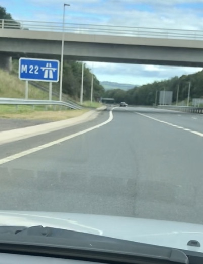
As for the new A6 expressway, don't rush up if you haven't already because you still don't quite get the direct connection experience - where it ties to the M22 it is in fact down to one lane while they sort out the junction!
I do think they should now be tidied up - it is actually genuinely unclear sometimes on traffic reports which "A2" or "M2" (particularly those two) is meant.
As for the new A6 expressway, don't rush up if you haven't already because you still don't quite get the direct connection experience - where it ties to the M22 it is in fact down to one lane while they sort out the junction!
-------------------------
Ian P. (IJP1)
Ian P. (IJP1)
-
AndyB
- Elected Committee Member
- Posts: 11136
- Joined: Tue Dec 26, 2006 21:58
- Location: Belfast N Ireland
- Contact:
Re: A6(NI) dualling to start
It's worth noting that the A2 Sydenham Bypass only has a concrete wall as part of the boundary with the railway. The narrow parts of the central reservation still have a steel barrier (and have done for decades) while one wider part near the City Airport has no barrier at all.nirs wrote: ↑Thu Aug 29, 2019 21:39 Tensioned cable is currently the norm here, though they do generate negative publicity fairly regularly from motorcycle lobby groups. We have installed concrete barriers, but only on roads with high AADTs – the first part of the M1 and M2, plus A12 Westlink and A2 Sydenham Bypass come to mind. Northern Ireland follows the same DMRB guidelines as England and Scotland.
Did a quick check of the barrier types on all DCs built in NI in the past decade, and every single one has a tensioned cable central barrier:
A6 Toome to Randalstown - 2019 - tensioned cable
A26 Glarryford to Drones Road - 2017 - tensioned cable
A2 Shore Road Greenisland - 2015 - tensioned cable
A8 dualling - 2015 - tensioned cable
A2 Maydown to City of Derry airport - 2011 - tensioned cable
A4 Ballygawley to Dungannon - 2010 - tensioned cable
A1 new Newry Bypass - 2010 - tensioned cable
You have to go back to the A515 Skeoge Link (Derry) in 2008 to find a steel crash barrier.

Re: A6(NI) dualling to start
The Aberdeen bypass and the A90 Balmedie - Tipperty dualling were built as a single contract, but the AWPR was built with concrete barriers and B-T with wire barriers, as they were designed as separate schemes.SouthWest Philip wrote: ↑Thu Aug 29, 2019 19:30 I thought wire central reservations barriers had gone out of vogue. Surprised to see one on a new build.
Owen Rudge
http://www.owenrudge.net/
http://www.owenrudge.net/

Re: A6(NI) dualling to start
A pre-partition classification of Irish roads into first and second class routes has been rumoured to exist, but I have never seen it. Presumably this would have formed the basis of subsequent numbering.IJP1 wrote: ↑Thu Aug 29, 2019 23:39 Just on Northern Ireland numbering in general, I have often wondered if the A-roads follow the old postal routes. Certainly the first postal route on the island was Dublin-Belfast; and the second veered off it roughly and Newry and circuited the north coast. It would not surprise me if the third was Belfast-Lisburn-Armagh and the fourth Belfast-Dungannon-Enniskillen given the "Linen Triangle" - Dungannon-Derry and then Derry-Belfast could conceivably even have been fifth and sixth, etc.
"I intend to always travel a different road"
Ibn Battuta 1304-1368
Ibn Battuta 1304-1368

Re: A6(NI) dualling to start
I personally think the A8 is atrocious. It's littered with too many private accesses, which all join the 70 mph road at a give way line. Many of them are very close to signed major exits (which must confuse a fair few people). There's also that huge roundabout that didn't previously exist and should surely be a GSJ instead.Owain wrote: ↑Tue Aug 27, 2019 17:03I have high expectations! I drove on the A8 not long after it was dualled, and it sets an excellent example of how a modern dual carriageway should be built; excellent sight lines, plenty of space to cater for broken down vehicles, and long slip roads leading to well-designed junctions. I was impressed, and have always enjoyed driving it. There's a mighty contrast between the A8 and the A75 and A77 on the other side of the water!RJDG14 wrote: ↑Tue Aug 27, 2019 16:20This is what the new A6 looked like on my trip the other week:
A6NewSection.jpg
The Toome bypass was dualled about 15 years ago (according to my parents they remember driving along it the first time they went together to see my Northern Irish grandad in 1998, but this looks to be a false memory and they may have been confusing it with a time when I was small), but is a similar standard apart for a couple of at-grade junctions, and the section between Toome and Castledawson is still in the process of being dualled, though the on-line sections definitely look as though they're nearing completion. The new road between Toome and Randalstown felt as though it pretty much halves the distance time from what it was on the old road.
I might manage to drive the newly dualled A26 north of Ballymena too; I remember that road - as it used to be - from my time living in Coleraine. It was very busy, and in one place very narrow, with lines of massive trees very close to the side of the road.
The best thing about the Isle of Man is this sign:RJDG14 wrote: ↑Tue Aug 27, 2019 16:20Owain wrote: ↑Tue Aug 27, 2019 15:56
In practice they're kind of part of the UK, though not in name and they have a high degree of autonomy. Both have agreements with the UK and (pre-Brexit) the EU meaning that they're in the Single Market and the Common Travel Area, and the laws in the Crown Dependencies are mostly clones or similar equivalents to those in the UK...It's probably the only place in the world - away from the German Autobahns - where it still has its original meaning.

On top of that, there were surely other roads that justified dualling before the A8 (I know that money was pledged from Dublin at the time).

Re: A6(NI) dualling to start
It's not just rumoured to exist, it absolutely did exist. But to be very specific, what had happened at the point the Irish Free State broke away from the UK was that county councils (across the whole of the then-UK) had performed traffic surveys on all their roads to ascertain traffic levels. The roads in each county were then sorted into class I, class II and unclassified roads.
Taking those three tiers of road, and allocating numbers to class I and II roads, only took place later. So at the point Ireland gained its independence, it had data telling it how busy all its roads were, and a basic exercise had been done to sort all those roads into three categories, but nothing else. It's therefore no surprise that the Irish numbering system set up shortly afterwards had three tiers just like the UK one does - though in Ireland class I became T-roads, not A-roads, and class II became L-roads, not B-roads.
Prior to Ireland gaining independence, some early ideas for the zonal system for A- and B-roads used only zones 7 and 8 for Scotland, on the basis that 7 and 8 between them had more than enough numbers to cover all Scotland's requirements. No mention is made in any official paperwork, as far as I've ever found, to say what role zone 9 might have played, if any, but it's interesting to speculate that the island of Ireland might have been zone 9. Again, though, no numbers were allocated, so that is just sheer speculation.
Chris
Roads.org.uk
Roads.org.uk

Re: A6(NI) dualling to start
I think you can’t disagree that allocating Zone 9 is overkill in Scotland.
Scotland (thought you could argue the whole UK as well) has embarrassingly low usage of B-Road numbers, and even A-roads too. A great number of 3-digit numbers are unused.
Scotland (thought you could argue the whole UK as well) has embarrassingly low usage of B-Road numbers, and even A-roads too. A great number of 3-digit numbers are unused.
Re: A6(NI) dualling to start
If you look at the roads lists on the wiki, you’ll find that almost all 3-digit A roads in zones 7, 8 and 9 are used (or have been used in the past). I can’t see how you could lose one of the zones without introducing lots of 4-digit roads, or what the benefit of doing so would be!
Looking at zone 9 in particular, it looks like pretty much all the 3-digit B roads have also been used, alongside a number of 4 digit too. Not sure how that is “overkill” to be honest.
Looking at zone 9 in particular, it looks like pretty much all the 3-digit B roads have also been used, alongside a number of 4 digit too. Not sure how that is “overkill” to be honest.
Owen Rudge
http://www.owenrudge.net/
http://www.owenrudge.net/

Re: A6(NI) dualling to start
So from 2021 the only non-dualled section between Derry and Belfast will be the Glenshane Pass. That is not at all a bad result! I always liked the A6, but all of it could be frustrating at peak times*, the Glenshane being the only exception.
*In the middle of the night the whole road was a dream (except Dungiven) .... I used to got from the ferry in Belfast Dock to Derry in just over an hour.

Re: A6(NI) dualling to start
Owain wrote: ↑Fri Sep 13, 2019 22:52So from 2021 the only non-dualled section between Derry and Belfast will be the Glenshane Pass. That is not at all a bad result! I always liked the A6, but all of it could be frustrating at peak times*, the Glenshane being the only exception.
*In the middle of the night the whole road was a dream (except Dungiven) .... I used to got from the ferry in Belfast Dock to Derry in just over an hour.
By breaking the speed limits unashamedly Owain? Naughty naughty!!
Certified Roads Geek ... and proud of it!

Re: A6(NI) dualling to start
About 20 years ago I had a girlfriend in Derry - at a time when I lived in Newtownabbey. I though I was doing well when I managed to do that journey in under an hour!
If it was late at night I’d pull into a lay-by on the Glenshane Pass and turn off all my lights. The darkness was on a level you don’t get in the city. It was nice to sit and soak in the stars.
If it was late at night I’d pull into a lay-by on the Glenshane Pass and turn off all my lights. The darkness was on a level you don’t get in the city. It was nice to sit and soak in the stars.
Northern Ireland Roads Site www.wesleyjohnston.com/roads
Re: A6(NI) dualling to start
Unfortunately, I would say not quite.
I would distinguish the Maghera-Castledawson/Magherafelt section from the Glenshane Pass. Like the Glenshane Pass, it has hard shoulders (so there'll be no tractor issue the entire length of the route) and the odd 2x1 section but it won't be dual.
Worth adding that, but for the ludicrous decision to leave the roundabouts at Toome, the whole section of which you speak would be at least expressway standard, not just dual.
-------------------------
Ian P. (IJP1)
Ian P. (IJP1)
-
AndyB
- Elected Committee Member
- Posts: 11136
- Joined: Tue Dec 26, 2006 21:58
- Location: Belfast N Ireland
- Contact:
Re: A6(NI) dualling to start
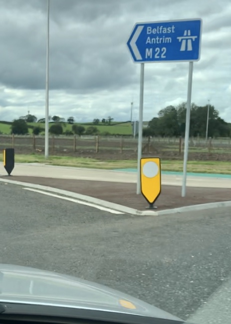
I've sent three queries off to DfI this afternoon, one of which covers the chopsticks sign. Wish me luck - it's not the only Diagram 2901 sign with the wrong font to have been erected in recent years...
-
A42_Sparks

- Member
- Posts: 958
- Joined: Mon Nov 17, 2003 23:20
- Location: Ballymena, N Ireland
Re: A6(NI) dualling to start
Good luck with your queries AndyB.
I travelled down this road again last night to check out the Randalstown West junction now that it's fully open. The chopsticks signs are still in the same place so it definitely looks like the permanent arrangement is that the M22 now starts about 100 yards east of the former j3. Perhaps the compact design of the junction meant it had to be off the motorway.
Interestingly the M22 eastbound flag sign at the roundabout is all blue, not green with a blue patch.
-
A42_Sparks
- Member
- Posts: 958
- Joined: Mon Nov 17, 2003 23:20
- Location: Ballymena, N Ireland
Re: A6(NI) dualling to start
I went to Magherafelt today almost a year after my last journey in the area. There have been a few interesting changes.
The big news is that the situation with the unusual chopsticks sign at the M22 former j3 (Randalstown West) has been resolved. The enormous and incorrect M22 chopsticks sign eastbound has been replaced by a more reasonably-sized one in the correct Motorway font. More importantly it has been placed in a much better position, just after the point where the onslip joins in front of the bridge. I suppose this is so only one chopsticks sign is required as the sliproads themselves are not under motorway restrictions.
Westbound the end of motorway sign has also been moved to a better position, just in front of the point where the offslip diverges. Sorry I didn't get a picture of that one
The sliproads are extremely tight with an advisory 20mph limit and presumably this is why they are not actually part of the motorway. At the roundabout there are chopsticks symbols on the ADS and onslip flag sign. I assume this is because the slip leads to a motorway even though it is actually part of the A6.
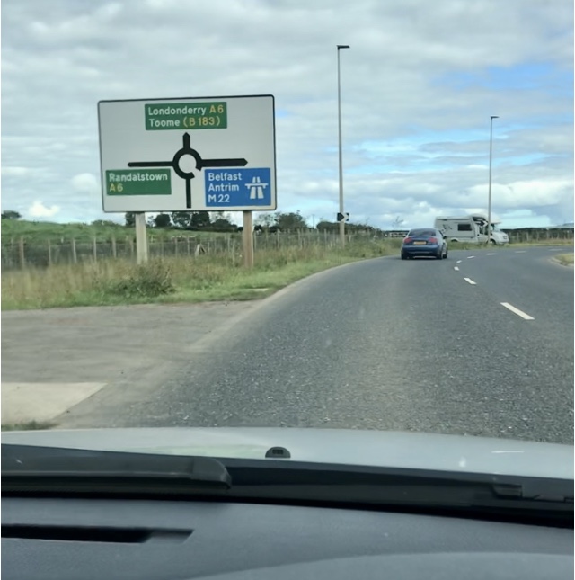
Seeing Antrim signed via the M22 is quite unusual and it can only happen at this junction. At j2 Antrim is signed via the A6 and at j1 via the A26.
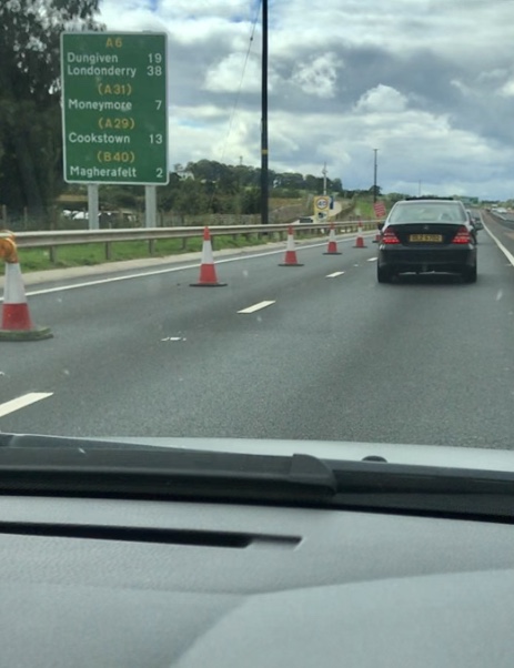
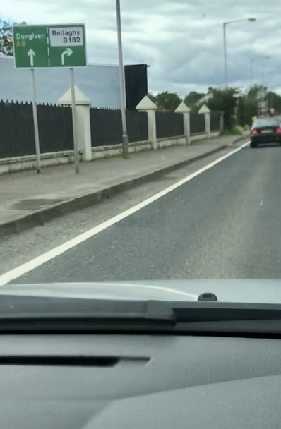
Further west work is coming along nicely on the Toome-Castledawson section. You can drive on the new A6 (westbound carriageway only) between Castledawson Roundabout and the B182 Hillhead Road flyover. There are a lot of huge new RCS along the A6 now. I can't remember Dungiven being signed from this far away on the A6 before.
Speaking of Dungiven, this new sign on the A6 before the B182 Hillhead Road flyover is very odd as it signs Dungiven as the 'ahead' destination. I would have signed Derry or even Magherafelt. This sign is probably temporary anyway as the A6 here will almost certainly soon be downgraded to B-road status.
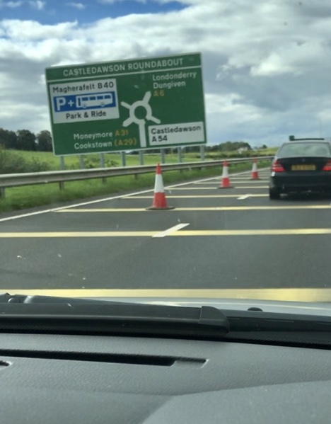
With the A6 dualling and the A31 Magherafelt bypass completed Castledawson Roundabout is an even more important junction than it used to be. This is reflected in the size of the ADS on the A6 approaching the roundabout. It's absolutely flippin' enormous and needs eight posts to hold it up! The photo doesn't really do it justice, it's certainly the biggest sign I've ever seen on a non-motorway road in Northern Ireland. And it's not really at a wonky angle, it's just my poor camera work
The big news is that the situation with the unusual chopsticks sign at the M22 former j3 (Randalstown West) has been resolved. The enormous and incorrect M22 chopsticks sign eastbound has been replaced by a more reasonably-sized one in the correct Motorway font. More importantly it has been placed in a much better position, just after the point where the onslip joins in front of the bridge. I suppose this is so only one chopsticks sign is required as the sliproads themselves are not under motorway restrictions.
Westbound the end of motorway sign has also been moved to a better position, just in front of the point where the offslip diverges. Sorry I didn't get a picture of that one
The sliproads are extremely tight with an advisory 20mph limit and presumably this is why they are not actually part of the motorway. At the roundabout there are chopsticks symbols on the ADS and onslip flag sign. I assume this is because the slip leads to a motorway even though it is actually part of the A6.
Seeing Antrim signed via the M22 is quite unusual and it can only happen at this junction. At j2 Antrim is signed via the A6 and at j1 via the A26.
Further west work is coming along nicely on the Toome-Castledawson section. You can drive on the new A6 (westbound carriageway only) between Castledawson Roundabout and the B182 Hillhead Road flyover. There are a lot of huge new RCS along the A6 now. I can't remember Dungiven being signed from this far away on the A6 before.
Speaking of Dungiven, this new sign on the A6 before the B182 Hillhead Road flyover is very odd as it signs Dungiven as the 'ahead' destination. I would have signed Derry or even Magherafelt. This sign is probably temporary anyway as the A6 here will almost certainly soon be downgraded to B-road status.
With the A6 dualling and the A31 Magherafelt bypass completed Castledawson Roundabout is an even more important junction than it used to be. This is reflected in the size of the ADS on the A6 approaching the roundabout. It's absolutely flippin' enormous and needs eight posts to hold it up! The photo doesn't really do it justice, it's certainly the biggest sign I've ever seen on a non-motorway road in Northern Ireland. And it's not really at a wonky angle, it's just my poor camera work
Re: A6(NI) dualling to start
Thanks for those! Only thing I'd say is that regardless of its radius, the eastbound onslip at j3 SHOULD be under motorway restrictions as it leads to the M22 with no opportunity for escape. It should be signed as such from the roundabout.
Northern Ireland Roads Site www.wesleyjohnston.com/roads