Star.pngStar grey.pngStar grey.pngStar grey.pngStar grey.png

Abandoned Road

From Roader's Digest: The SABRE Wiki
Jump to navigation Jump to search
Abandoned Road
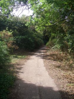
20180804-1033 - Old B1368 heading towards Puckeridge 51.893308N 0.014971E.jpg
The former B1368 heading towards Puckeridge
Cameraicon.png Pictures related to Abandoned Road
View gallery (596)


An abandoned road is a route which has fallen out of use, usually because the route has been realigned or bypassed as part of a junction improvement.

See Also: Oxbow Road

List of Abandoned Roads

Abandoned roads have been listed in five country pages as follows:

See also: Category:Drowned Bridges


Abandoned Road
Related Pictures
View gallery (596)
A82 Glen Falloch - Coppermine - 16987.jpgA47 Abandoned section of the A47 - Coppermine - 2356.jpgKirk of Shotts Bypass 1 - Coppermine - 18042.jpgA12 (former) at Copdock - 2 - Coppermine - 5727.JPGOld roads2 185.jpg
Abandoned Roads
 • List of Abandoned Roads in England  • List of Abandoned Roads in Scotland  • List of Abandoned Roads in Wales  • List of Abandoned Roads in Northern Ireland  • List of Abandoned Roads in Ireland

Related:
Road Basics
Physical layoutSingle track • Single carriageway • Dual carriageway • High Quality Dual Carriageway • Road Widths • Urban Streets • Abandoned Road
Legal typesAll-purpose Road • Special Road • Motorway • Trunk road • Principal road • Classified Numbered road • Classified Unnumbered Road • Unclassified road • Primary Route • Non Primary Route • Right of Way • Unadopted road
Road numbers1922 Road Lists • Classification • Defunct road • Euroroutes • MoT Maps • National Cycle Network • Numbering principles • Numbering anomalies • Disputed Numbers • Recycled number • Unallocated numbers • Fictional Road Numbers • Junction numbers • Essential Traffic Routes
Road FeaturesArterial Road • Automatic Bollard • Balancing Pond • Belisha Beacon • Bott's Dots • Bypass • Cannon • Cats' Eyes • Cattle Grid • CD Lanes • Central Reservation • Chopsticks • Crash Barrier • Cuttings and Embankments • Cycle Lane • Emergency Phone • Escape lane • Expressway • Fingerpost • Flare • Ford • Gore • Green Bridge • Green Wave • Hairpin bend • Hard shoulder • Island • Junction • Layby • Level Crossing • Local Access Road • Managed Motorways • Milestone • Multi Lane Drop • Multiplex • No-Car Lane • Nose • Oxbow Road • Parapet • Petrol station • Play Street • Raised Pavement Markers • Ramp Metering • Retaining Wall • Road Studs • Roadside Art • Roadside Quarry • Roadworks • Secret motorway • Signage • Smart Motorway • Snow pole • Speed Limit • Spur • Street Lighting • Surface Dressing • Temporary terminus • Throughpass • Tidal Flow • Tiger tail • Toll booth • Traffic cone • Traffic Signals • Tunnel • Vehicle Recovery • Walking and Cycling Friendly Road • Weaving • Wig-Wag Signals • Winter Maintenance • Zip merge
Traffic CalmingBuild-Outs • Chicane • Dragon's Teeth • Home Zone • Low Traffic Neighbourhood • Pinch Point • Quiet Lane • Rumble strips • Safety Cameras • Sleeping Policeman • Speed bump
Public Transport FeaturesBus Lane • Bus stop • Guided Busway • Park and Ride • Tramway • Trolleybus System
Other termsAnderson report • Guildford Rules • Highway Authority • Highway Code • Model Traffic Area • Motorway alphabet • Pre-Worboys • Primary Destinations • Roads by 10 • Transport alphabet • Worboys report
AcronymsAADT • ADS • ANPR • ATM • DfT • GSJ • HA • HATO • HE • HETO • HQDC • LAR • LILO • LTN • MOVA • NCN • NMU • NRA • PBU • POPE • PTS • PFI • RCS • SABRE • SCOOT • SSD • SON • SOX • SRN • TEN-T • TERN • TfL • TII • TOTSO • TRO • TSM • TSRGD • UTC • VAS • VMS • VSL


SABRE - The Society for All British and Irish Road Enthusiasts
Discuss - Digest - Discover - Help