Star.pngStar.pngStar grey.pngStar grey.pngStar grey.png

B38 (Selly Oak)

From Roader's Digest: The SABRE Wiki
Jump to navigation Jump to search
B38
B38.png
Cameraicon.png View gallery (2)
From:  Bournbrook (SP047832)
To:  Selly Oak (SP041825)
Distance:  0.6 miles (1 km)
Met:  A38, A38
Former Number(s):  A38
Now part of:  B384
Traditional Counties

Warwickshire

Route outline (key)
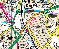
B38 Bournbrook - Selly Oak
A flag sign for the B38

The non-standard number B38 was seemingly allocated to the former A38 in Selly Oak, Birmingham upon opening of the bypass in 2011. The road linked the A38 to itself, starting by Tesco then climbing Bristol Road under the Cross City Line to end at the Selly Oak Triangle.

In December 2011, the Department for Transport confirmed they were aware of the abnormal numbering, as B roads are three or four digit numbers long, and were discussing the issue with Birmingham City Council.

In early 2012, all the signs were patched with B384 patches.

In 2022, the A77 through Maybole was renumbered B77 on being bypassed, and the Scottish authorities refused to change the number, thus creating the first permanent exception to the once-accepted rule.


B38 (Selly Oak)
Related Pictures
View gallery (2)
B38.jpgB38.png
Other nearby roads
Birmingham
A34 • A38 • A38(M) • A41 • A42 (Reading - Birmingham) • A45 • A47 • A435 • A441 • A452 • A453 • A455 (Birmingham - Stafford) • A456 • A457 • A458 • A4027 • A4028 • A4029 • A4030 • A4040 • A4097 • A4123 • A4166 • A4167 • A4400 • A4540 • A4723 • A5127 • B384 • B3800 • B4025 • B4043 • B4096 • B4100 (Birmingham) • B4114 • B4118 (Birmingham) • B4120 • B4121 • B4122 (Birmingham) • B4123 • B4124 • B4125 • B4126 • B4127 • B4128 • B4128 (Suffolk Street, Birmingham) • B4129 • B4129 (Birmingham City Centre) • B4130 • B4131 • B4132 • B4133 • B4134 • B4135 • B4136 • B4137 • B4140 • B4141 (Birmingham) • B4142 • B4143 (Birmingham) • B4144 • B4145 • B4146 • B4147 • B4148 • B4167 • B4182 • B4217 • B4284 • B4498 • B4514 • B4515 • B4516 • B4531 • B4532 • B4533 • B4552 • B4730 • E05 • E24 • E28 (Birmingham - Ipswich) • E33 (London - Glasgow) • E116 (Old System) • Holyhead Road • Longest Lane • M5 • M6 • M40 • M42 • M600 • Northern and Western Motorway • Ryknild Street • T13 (Britain) • T14 (Britain) • T15 (Britain) • T16 (Britain) • T35 (Britain) • T53 (Britain)
B300 – B399
B300 • B301 • B302 • B303 • B304 • B305 • B306 • B307 • B308 • B309 • B310 • B311 • B312 • B313 • B314 • B315 • B316 • B317 • B318 • B319
B320 • B321 • B322 • B323 • B324 • B325 • B326 • B327 • B328 • B329 • B330 • B331 • B332 • B333 • B334 • B335 • B336 • B337 • B338 • B339
B340 • B341 • B342 • B343 • B344 • B345 • B346 • B347 • B348 • B349 • B350 • B351 • B352 • B353 • B354 • B355 • B356 • B357 • B358 • B359
B360 • B361 • B362 • B363 • B364 • B365 • B366 • B367 • B368 • B369 • B370 • B371 • B372 • B373 • B374 • B375 • B376 • B377 • B378 • B379
B380 • B381 • B382 • B383 • B384 • B385 • B386 • B387 • B388 • B389 • B390 • B391 • B392 • B393 • B394 • B395 • B396 • B397 • B398 • B399
Former Iterations: B38 • B303 • B310 • B311 • B384

This page includes a scan of a non-free copyrighted map, and the copyright for it is most likely held by the company or person that produced the map. It is believed that the use of a limited number of web-resolution scans qualifies as fair use under United States copyright law, where this web page is hosted, as such display does not significantly impede the right of the copyright holder to sell the copyrighted material, is not being used to generate profit in this context, and presents information that cannot be exhibited otherwise.
If the copyright holder considers this is an infringement of their rights, please contact the Site Management Team to discuss further steps.

SABRE - The Society for All British and Irish Road Enthusiasts
Discuss - Digest - Discover - Help