Rest and be Thankful
| Rest and be Thankful | |||
| Location Map ( geo) | |||
 | |||
| |||
| Location | |||
| Glen Croe | |||
| County | |||
| Argyll | |||
| Highway Authority | |||
| Transport Scotland | |||
| Junction Type | |||
| T junction | |||
| Roads Joined | |||
| A83, B828 | |||
| Junctions related to the A83 | |||
| Junctions related to the Argyll Coastal Route | |||
The Rest and be Thankful is the summit of the pass on the A83 between Arrochar and Inveraray. It sits at the head of Glen Croe and is where the B828 turns off to descend to the coast at Lochgoilhead.
History
The road over The Rest is doubtless the course of a historic Drovers Road linking Inveraray and southern Argyll with the markets of the central belt. However, following the second Jacobite uprising in 1745-6, Major Caulfeild took over where Wade had left off and extended the Military Road network in Scotland. One of the new roads he built was the route that crossed the Rest and be Thankful.
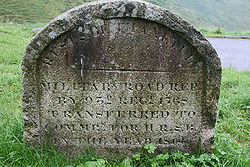
In the car park at the summit, apart from seeing some spectacular views, you can also find the stone (right) which bears the following inscription:
Military Road Repaired by 93rd Regt 1768 Transferred to Commissioners for Highland Roads and Bridges in the year 1814.
This tells us that the road, which was probably built in the early 1750s at the same time as the road across Rannoch Moor was built, was already in need of repair in 1768. It also tells us that when Thomas Telford took on his Commission for Highland Roads, he was also responsible for rebuilding the military road network, and had worked his magic at the Rest and be Thankful by 1814 when he handed the road to the commissioners.
Today
Today the Rest and be Thankful is best known as a popular viewpoint and picnic site on the A83. To the east, the view down Glen Croe is marked by the course of two roads. The higher one is the modern road to Arrochar, which had opened by August 1945 (construction having started in 1938) and has been plagued by landslides from the steep hillside above in recent years. Below is the old Military Road, in use until the new road opened as the main road linking Inveraray, Cowal and Kintyre to the outside world.
The car parking is partially constructed on the old road, which heads out in the far corner from the entrance, along a little ledge cut on the hillside below the B828, before taking a tight hairpin back to descend the hill. By the time it lines up below the modern A83, much of the height difference has already been lost, and the two roads then descend almost at the same gradient. The old road remained tarred and used as access to the farm and forestry in the glen until c2012, when work started to recommission it. This was not a permanent diversion for the A83, but instead an emergency diversion route which could be operated under a convoy system when the new road became blocked by landslips.
In 2020, a consultation was launched by Transport Scotland into a strategic solution for the issue of the continual closures of the pass.
Junction
Apart from all of the history and interest that this spot has, there is also an important junction here. Or at least it is important if you live in Lochgoilhead! The B828 which has climbed up from the coastal resort village meets the A83 here at a simple T-junction today. The car park entrance branches off the B road almost immediately, and this is the old line of the military road. As part of the works to recommission the old road, the car park was redesigned to ensure that traffic using the old road flowed as smoothly as possible. There is now also a bus turning circle sitting just above the car park on the B828.
| Route | To | Notes |
| Campbeltown, Oban (A819) | Argyll Coastal Route | |
| Glasgow (A82) | Argyll Coastal Route | |
| Lochgoilhead |
Links
Arrochar, Tarbet and Ardlui Heritage
- History of the Rest and be Thankful October 2005 (archive.org)
BBC News


