Alconbury North Interchange
| Alconbury North Interchange | |||
| Location Map ( geo) | |||
 | |||
| |||
| Location | |||
| Alconbury | |||
| County | |||
| Huntingdonshire | |||
| Highway Authority | |||
| National Highways | |||
| Junction Type | |||
| Fork | |||
| Opening Date | |||
| 1957 | |||
| Roads Joined | |||
| A1(M), (A1307) | |||
Alconbury North Interchange is junction 14 of the A1(M).
For many years, this junction is where traffic that wants East London turns off the A1 - for a long time this was via the Old North Road (the A14 (Royston to Alconbury) and A10, and then via the A604/A14 and M11. It was also the furthest north that The City was signed (as London (City & West) A1(M)). However, since the opening of the Huntingdon to Cambridge Improvement, all long distance traffic is now signed further south to Brampton Hut interchange.
History
The junction is positioned broadly on the line of the historic Ermine Street. The modern B1043 is a close approximation to the route that road took. This road was designated A14.
When the A1 was given a bypass of Alconbury in 1964, this new dual carriageway used part of the route of that existing A14. Near Alconbury Weston, the A1 continued south on a totally new route while the A14 headed off east as it always had done. The interchange between the two was built as a standard Trumpet Interchange. The loop would be considered tight by modern standards but not by the standards of the time, while the southbound offslip took a much gentler alignment.
In the mid-1970s the A14 was upgraded to a dual carriageway, but the junction remained how it was. The flyover was still single carriageway and the new alignment used part of the southbound onslip, making that appear shorter and tighter.
The A14 was designated A604 and the northbound offslip - the main part of the loop - was closed. It was poorly aligned and had been rendered redundant by improvements to Thrapston Road near Brampton Hut. The other sliproads remained.
In 1998 the new A1(M) and A604(M) (since re-numbered) opened. This replaced the remains of the trumpet with a well-aligned fork: despite the simpler layout, it's much larger than the old trumpet. The old southbound onslip can still just about be made out, while no evidence remains of the loop, which would have been immediately south of the modern-day flyover.
Routes
| Route | To | Notes |
| The NORTH, Peterboro', Stamford | ||
| London (City & West) | Furthest north that The City is signed. | |
| London (East), Huntingdon, Cambridge, Stansted Airport | ||
| London (East), Huntingdon, Cambridge, Stansted Airport | ||
| London (East), Huntingdon, Cambridge, Stansted Airport |
Strip Maps
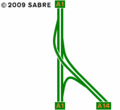
Alconbury North Interchange as it was before it became a motorway junction.
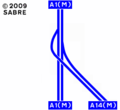
The layout of the interchange until 2019.
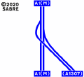
The present layout of the interchange .


Links
Grid References

_-_Coppermine_-_7353.jpg)
_-_Coppermine_-_7354.jpg)
_-_Coppermine_-_7355.jpg)