A1301 (Essex)
| A1301 | ||||
 | ||||
| From: | Sadlers Farm (TQ762883) | |||
| To: | Canvey Island (TQ799836) | |||
| Distance: | 4.2 miles (6.8 km) | |||
| Met (1975): | A13 | |||
| Now part of: | A130, B1014 | |||
| Traditional Counties | ||||
| Route outline (key) | ||||
| ||||
For the present A1301 in Cambridgeshire, see A1301.
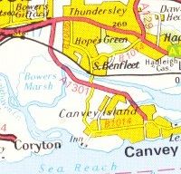
The A1301 number was formerly allocated to a road which opened on 9 April 1973, connecting the A13 at the Sadlers Farm roundabout in south Essex to Canvey Island.
Crossing the East Haven Creek by means of a new causeway and bridge it intersected the B1014 Canvey Road (which connected the island to the mainland at South Benfleet) at a roundabout by Waterside Farm northwest of Canvey Island town, from there skirting the northern edge of the built-up area to end at a second meeting with the B1014 close to the library at the west end of Canvey Island High Street.
When the A130 was extended south to meet the A13 at Sadlers Farm towards the end of the 70s, it also took over the route of the A1301 to Canvey and the latter number became defunct. A further change that occurred at the same time was that from the aforementioned Waterside Farm roundabout the A130 (former A1301) and the B1014 swapped numbers for their respective southward and eastward runs into Canvey Island town centre.
| A1301 (Essex) | ||
| ||
|
This page includes a scan of a non-free copyrighted map, and the copyright for it is most likely held by the company or person that produced the map. It is believed that the use of a limited number of web-resolution scans qualifies as fair use under United States copyright law, where this web page is hosted, as such display does not significantly impede the right of the copyright holder to sell the copyrighted material, is not being used to generate profit in this context, and presents information that cannot be exhibited otherwise.
If the copyright holder considers this is an infringement of their rights, please contact the Site Management Team to discuss further steps.
