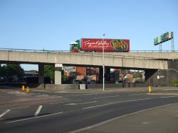
A4053 J3
Jump to navigation
Jump to search
| A4053 Junction 3 | |||
| Location Map ( geo) | |||
 | |||
| |||
| Location | |||
| Coventry City Centre | |||
| County | |||
| Warwickshire | |||
| Highway Authority | |||
| Coventry | |||
| Junction Type | |||
| Directional-T + Roundabout | |||
| Roads Joined | |||
| A4053, A4600 | |||
| Junctions related to the A4600 | |||
Junction 3 of the Coventry Ring Road serves as the main access point to the city centre from the east and north.
Routes
| Route | To | Notes |
| Ring Road, Birmingham (A45), Cov & Wark Hospital, West Orchards, Sports Centre, Coventry University Car Parks | ||
| Ring Road, (M1 South, M40), Rugby (A45), Warwick (A46), Coventry Airport, Whitely, Technology Park | ||
| (M6, M69), (M1), Leicester (A4600), Nuneaton (A444), Rugby (A428), Lutterworth (A427) | ||
| Lower Ford Street | ||
| Far Gosford Shopping Centre, FAR GOSFORD STREET | ||
| Gosford Street |
| A4053 J3 | ||
| ||
|
