Ascension Island/New Mountain Road
| New Mountain Road | |||
| Location Map ( geo) | |||
| |||
| From: | Cat Hill | ||
| To: | Red Lion, Green Mountain | ||
| Via: | Travellers Hill | ||
| Distance: | 3.5 miles (5.6 km) | ||
| Highway Authorities | |||
Ascension Island Government | |||
For over 100 years, the Old Mountain Road was the only route up Green Mountain. However, with the opening of the Wideawake Airfield in June 1942, and the subsequent development of the south of the island, a new road was built to directly connect the RAF accommodation at Two Boats back to the airfield. This came to be known as the New Moutain Road, and now enjoys priority (in signage and road markings) over the older route.
Starting on the Airhead Road just south of Cat Hill, the road sets off in an easterly direction, and after a couple of kinks opens out into a long wide straight, perhaps the fastest piece of road on the island, or at least it would be if there wasn't a 40 limit! There is a slight bend mid way, but you'll need to keep an eye out for the junction, and turn left, as otherwise you'll be heading out on the NASA Road! The road now climbs through scrub, turning slowly along the southern flank of Lady Hill to head east again and quickly enter Travellers Hill. This is the newer of the two RAF settlements on the island, looking slightly mote severe, and is predominantly short term, unlike the longer term residences of Two Boats. A big double bend then lifts us up the side of Travellers Hill itself, and brings us to another TOTSO, although this time in our favour.
Green Mountain Road
Turning left takes us onto the Old Mountain Road through Two Boats and back to Georgetown, but straight ahead is the fun bit. A huge area off to the left is marked out as the school playing field, albeit one entirely devoid of grass, and at the top is a wooden sign welcoming us to Green Mountain National Park. The road remains S2 at first, swinging round a left hander as it starts to climb, with a Pre Worboys 'Keep in Low Gear' sign on the bend.
The climb up this ridge of Green Mountain is immense. Nearly 500m of ascent in under a mile, through a series of switchbacks and hairpins. However, on Ascension it is not the bends that seem important, but the road between, with many having name plates - they are referred to as Ramps. A couple of times the road seems to level out, and straighten up, but don't be fooled, and by the second one the road seems to have dropped to S1, despite the steep blind bends yet to come. A double back right turn leads to the Administrators Residence - a former sanitorium and owing to dampness perhaps one of the least salubrious head of state residences in the world! At long last the climb eases for a third time, and with some parking spaces to the sides, followed by buildings the end comes into sight.
Between the two sets of hairpins on the climb up Green Mountain, there are around a dozen real hairpin bends, with 5 of these in the very tight series of bends just below the driveway to The Residency. There are another half dozen or so bends which are either very sharp double-backs or steep which don't quite qualify as hairpins! Fortunately the road is quiet, although the chances are that any vehicle met will be a fast moving Land Rover, which will make short work of the Fiesta hire cars.
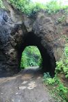
The road finishes in the yard of the former barracks at the top of the hill, incongrously known as the Red Lion. The building later served as a farm, along with the cottages nearby, but has been redundant since the late 1990s. On clear days, there are good views out to the north and west of the island, as there are indeed here and there on the way up, although sensible parking spaces are limited. There is parking for perhaps 4 cars in the yard, with room for more lower down, and the road itself continues, although not really usable by normal cars, even higher. After a short narrow straight, a hairpin takes the road through a rock-cut arch, and then winds ever higher through more sharp bends to reach the original barracks at the summit, later converted to cow sheds!
A series of walks run around Green Mountain and up to the summit, and provide fascinating views and other points of interest. Whilst rarely more than 1m / 3ft wide, they were purposefully cut through the volcanic rock (of the consistency of Tarmac!) by soldiers so that the mountain could be used as a lookout point. However, at the same time, a variety of bushes and plants were being planted on the summit, with the joint intention of providing food and generating rainfall. This latter plan was so succesful that the lookout duties had to be abandoned due to the foliage and cloud cover!


