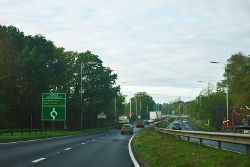
Azalea Roundabout
Jump to navigation
Jump to search
| Azalea Roundabout | |||
| Location Map ( geo) | |||
 | |||
| Advance Direction Sign for the roundabout | |||
| |||
| Location | |||
| St Leonards | |||
| County | |||
| Dorset | |||
| Highway Authority | |||
| National Highways | |||
| Junction Type | |||
| Roundabout | |||
| Roads Joined | |||
| A31 | |||
Azalea Roundabout is a roundabout on the A31 near St Leonards in Dorset. There was a motel with the same name near the junction.
The roundabout is curious because it does not provide access to anything - there are only field accesses. There are a couple of theories about why it might be located here. The first is that there is a farm crossing just to the east of the roundabout, to allow livestock movement. The roundabout may have been put in place to slow traffic on approach.
The second theory is that when existing Oakdene Forest Park, you can only turn left, so the roundabout may have been added to allow traffic to also head westbound on exit.
Routes
| Route | To | Notes |
| Ringwood, St Leonards | ||
| Dorchester, Bournemouth (A347), Poole (A349), Ferndown, Wimborne |
