Star.pngStar.pngStar grey.pngStar grey.pngStar grey.png

B1309 (Jesmond)

From Roader's Digest: The SABRE Wiki
Jump to navigation Jump to search
B1309
B1309-Jesmond.png
Cameraicon.png View gallery (2)
From:  West Jesmond (NZ249670)
To:  Newcastle upon Tyne (NZ259645)
Via:  Osborne Road, Stoddart Street
Distance:  1.9 miles (3.1 km)
Met (1963) A189, B1310, A1058, B1307, A695
Now part of:  B1600
Traditional Counties

Northumberland

Route outline (key)
B1309 West Jesmond - Newcastle upon Tyne
This article is about the original B1309 between West Jesmond and Newcastle upon Tyne.
For the current B1309 in Newcastle upon Tyne city centre, see B1309
.


Osborne Road, Jesmond

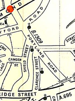
The original route of the B1309 ran southwards from Jesmond to the east of Newcastle upon Tyne city centre.

It started on the A189 Jesmond Dene Road and zigzagged through the streets, remaining fairly close to the railway line. It crossed the A1058 Jesmond Road at a staggered crossroads before going along Clarence Street to end on the A695 New Bridge Street.

It is now part of the longer B1600, although the southern end of the road has been diverted for a tower block to be built.



B1309 (Jesmond)
Related Pictures
View gallery (2)
B1309-Jesmond.pngOsborne Road, Jesmond - Geograph - 1127473.jpg
Other nearby roads
Newcastle upon Tyne
A1 • A1(M) • A1(M)/Newcastle Central Motorway East • A1/Sandbox • A69 • A108 (Seaham - Seaton Burn) • A167 • A167(M) • A184 • A186 • A187 • A188 • A189 • A191 • A193 • A695 • A695(M) • A696 • A696(M) • A1056 (Northumberland) • A1057 (Newcastle upon Tyne) • A1058 • A1058(M) • A1059 (Newcastle upon Tyne) • A1060 (Newcastle upon Tyne) • A6082 • A6085 • A6086 (Newcastle-upon-Tyne) • A6115 (Tyneside) • A6125 • A6126 • A6127 • A6127(M) • B1296 • B1304 (Newcastle) • B1305 • B1305 (Quayside, Newcastle) • B1306 (Newcastle) • B1307 • B1308 (Newcastle) • B1309 • B1310 • B1311 • B1311 (Byker) • B1312 • B1312 (Byker) • B1313 • B1314 • B1318 • B1600 • B6323 • B6324 • B6325 (Newcastle) • B6326 (Newcastle) • B6327 • B6328 • B6329 • B6330 • B6331 • B6332 • B6333 • B6334 • B6335 • B6336 • B6337 • B6338 • B6339 • B6340 (Gosforth) • B6431 (Newcastle upon Tyne) • B6440 • B6528 • B6534 • C101 (Newcastle upon Tyne) • C103 (Newcastle upon Tyne) • C104 (Newcastle upon Tyne) • C105 (Newcastle upon Tyne) • C106 (Newcastle upon Tyne) • C107 (Newcastle upon Tyne) • C108 (Newcastle upon Tyne) • C109 (Newcastle upon Tyne) • C110 (Newcastle upon Tyne) • C111 (Newcastle upon Tyne) • C112 (Newcastle upon Tyne) • C113 (Newcastle upon Tyne) • C114 (Newcastle upon Tyne) • C115 (Newcastle upon Tyne) • Central Motorway East Bypass • Central Motorway West • E15 • E18 • E31 (via Newcastle) • E110 (Old System) • East-West Underground Motorway • Friars Goose Crossing • T1 (Britain) • T25 (Britain) • T86 (Britain)
B1300 – B1399
B1300 • B1301 • B1302 • B1303 • B1304 • B1305 • B1306 • B1307 • B1308 • B1309 • B1310 • B1311 • B1312 • B1313 • B1314 • B1315 • B1316 • B1317 • B1318 • B1319
B1320 • B1321 • B1322 • B1323 • B1324 • B1325 • B1326 • B1327 • B1328 • B1329 • B1330 • B1331 • B1332 • B1333 • B1334 • B1335 • B1336 • B1337 • B1338 • B1339
B1340 • B1341 • B1342 • B1343 • B1344 • B1345 • B1346 • B1347 • B1348 • B1349 • B1350 • B1351 • B1352 • B1353 • B1354 • B1355 • B1356 • B1357 • B1358 • B1359
B1360 • B1361 • B1362 • B1363 • B1364 • B1365 • B1366 • B1367 • B1368 • B1369 • B1370 • B1371 • B1372 • B1373 • B1374 • B1375 • B1376 • B1377 • B1378 • B1379
B1380 • B1381 • B1382 • B1383 • B1384 • B1385 • B1386 • B1387 • B1388 • B1389 • B1390 • B1391 • B1392 • B1393 • B1394 • B1395 • B1396 • B1397 • B1398 • B1399
Earlier Iterations: B1300 • B1304 • B1305 • B1306(W) • B1306(E) • B1308 • B1309 • B1312 • B1318 • B1320 • B1330 • B1332 • B1333 • B1335 • B1336
B1343 • B1344 • B1345 • B1353 • B1358 • B1360 • B1361(E) • B1361(W) • B1372 • B1373 • B1375 • B1378 • B1380 • B1383 • B1389 • B1392 • B1393 • B1397

SABRE - The Society for All British and Irish Road Enthusiasts
Discuss - Digest - Discover - Help