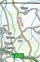
B3219 (Whiddon Down - Winkleigh)
| B3219 | ||||||||||
 | ||||||||||
| From: | Whiddon Down (SX690926) | |||||||||
| To: | Winkleigh (SS633079) | |||||||||
| Distance: | 11.9 miles (19.2 km) | |||||||||
| Met (1991): | A382, A3072, B3220 | |||||||||
| Now part of: | A3124 | |||||||||
| Traditional Counties | ||||||||||
| Route outline (key) | ||||||||||
| ||||||||||
For the original route of the B3219 to the west of Okehampton, now part of the A386, see B3219 (Folly Gate - Sourton Down).

The B3219 number was reused around 1991 for a previously unclassified road in mid-Devon. However, the number was short-lived as it became part of the A3124 in 1997.
The road started at Whiddon Down on the original line of the A30 (present A382) just west of the junction of those two roads. It headed north and soon went over the A30 before continuing across undulating terrain. It passed through no places of any size, perhaps explaining why this road was unclassified for so long despite its apparent high quality.
Presently the road reached a T-junction on the A3072, which appears to be the North Tawton bypass but in fact that village has never had a classified road running through it. After a multiplex to the west of over a mile the B3219 regained its number by turning right, back towards North Tawton, then had to TOTSO left at Culm Cross.
After another few miles heading north, still passing through no villages at all, the road reached the southern edge of Winkleigh and bore right onto the bypass, which dates to around the same time as the B3219 itself. The road ended a short distance further on on the B3220.
This page includes a scan of a non-free copyrighted map, and the copyright for it is most likely held by the company or person that produced the map. It is believed that the use of a limited number of web-resolution scans qualifies as fair use under United States copyright law, where this web page is hosted, as such display does not significantly impede the right of the copyright holder to sell the copyrighted material, is not being used to generate profit in this context, and presents information that cannot be exhibited otherwise.
If the copyright holder considers this is an infringement of their rights, please contact the Site Management Team to discuss further steps.

