Bannfield Bridge
Jump to navigation
Jump to search
| Bannfield Bridge | |||||
| Location Map ( geo) | |||||
 | |||||
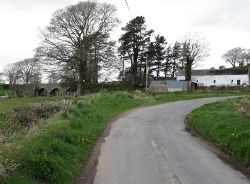
| Looking north to Bannfield bridge from Bannfield Road in 2013 | |||||
| |||||
| From: | Moneygore | ||||
| To: | Lisnisk | ||||
| County | |||||
| Down | |||||
| Highway Authority | |||||
| DfI Roads | |||||
| Opening Date | |||||
| late C19th | |||||
| Additional Information | |||||
| |||||
Bannfield Bridge is a triple arch masonary road bridge carrying a minor road over the Upper Bann. The listing gives the following information about its history: This bridge dates from the later 1800s. The 1833 OS six-inch map cites ‘Bannfield Steps’ at this location, and the 1859 edition notes 'Bannfield Wooden Foot Bridge’. The present bridge first appears on the 1902 map (‘Bannfield Bridge’) and subsequent editions. It was undoubtedly erected by the County Down Grand Jury under the presentment system, but when exactly between 1859 and 1902 it replaced the wooden footbridge is uncertain[1].
References
| Bannfield Bridge | ||||||
| ||||||
|
