Star.pngStar grey.pngStar grey.pngStar grey.pngStar grey.png

Bedford Bypass Viaduct

From Roader's Digest: The SABRE Wiki
Jump to navigation Jump to search
Bedford Bypass Viaduct
Location Map ( geo)
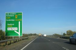
Bedford bypass (C) SJB - Geograph - 2677690.jpg
Cameraicon.png View gallery (1)
Location
North Eastern end of Bedford Bypass
County
Bedfordshire
Highway Authority
National Highways
On road(s)
A421
The name of this Junction / Bridge may not be accurate because
Questionable name

Bedford Bypass Viaduct crosses the River Great Ouse on the A21 north east of Bedford . This major route runs from near Bicester and Milton Keynes to the A1.


Bedford Bypass Viaduct
Related Pictures
View gallery (1)
Bedford bypass (C) SJB - Geograph - 2677690.jpg
Crossings of the River Great Ouse
Syresham Bypass • Brackley Bypass 2 • Brackley Bypass 1 • Bourton (Buckingham) Bridge  • Stony Stratford Bypass • M1 Viaduct, Newport Pagnell • North West Bridge • Olney Bridge • Turvey Bridge • Paula Radcliffe Way Bridge 2 • Paula Radcliffe Way Bridge 1 • Bromham Bypass Bridge • County Bridge (Bedford) • Town Bridge (Bedford) • Longholme Bridge • Bedford Bypass Viaduct • Tempsford Bridge • St Neots Bypass Bridge • St Neots Bridge • Mill Lane Bridge • A14 Expressway Viaduct • Huntingdon Bypass Bridge • Huntingdon Bridge • St Ives Bridge • St Ives Bypass Bridge • Earith Bridge • Twenty Pence Bridge • Chittering Bridge • Stretham Bridge • Ely High Bridge • Queen Adelaide Bridge • Littleport Bridge • Downham Bridge • Kings Lynn Bypass Bridge


SABRE - The Society for All British and Irish Road Enthusiasts
Discuss - Digest - Discover - Help