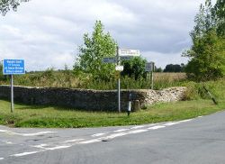
Betty's Grave
Jump to navigation
Jump to search
| Betty's Grave | |||
| Location Map ( geo) | |||
 | |||
| Fingerpost at Betty's Grave | |||
| |||
| Location | |||
| Poulton | |||
| County | |||
| Gloucestershire | |||
| Highway Authority | |||
| Gloucestershire | |||
| Junction Type | |||
| Crossroads | |||
| Roads Joined | |||
| unclassified | |||
Betty's Grave is a rural crossroads near Cirencester. It is named as being the final resting place of Elizabeth Bastre - however, there are various explanations for what Elizabeth Bastre really was since she was buried here in 1786. The options are: a witch that was hanged or burned at the stake; a suicide; murder victim; a woman who died from exposure; or a thief hanged for steeling sheep (source: Great British Ghost Tour). An alternative theory is that she was a gypsy woman who lived beyond her 100th birthday (Source: Daily Telegraph)
Routes
| Route | To | Notes |
| Poulton | ||
| Quenington, Coln St Aldwyns | ||
| Ready Token, Bibury | ||
| Cirencester |
| Betty's Grave | ||||
| ||||
|

