Star.pngStar.pngStar.pngStar grey.pngStar grey.png

Brenzett Roundabout

From Roader's Digest: The SABRE Wiki
Jump to navigation Jump to search
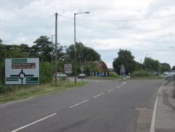
Brenzett Roundabout
Location Map ( geo)
Brenzett Roundabout - Geograph - 2046155.jpg
Cameraicon.png View gallery (1)
Location
Brenzett
County
Kent
Highway Authority
National Highways
Junction Type
Roundabout
Roads Joined
A259, A2070, B2080
Junctions related to the A2070

Brenzett Roundabout is a junction between Rye and New Romney.


The junction was originally slightly to the south-east of the current roundabout (1965 map)


Routes

Route To Notes

A259

Hastings, Rye, Brookland

A259

Folkestone, Hythe, Lydd Airport, New Romney

A2070

(M20), Ashford, Hamstreet

(B2080)

Tenterden, Appledore, Snargate


Brenzett Roundabout
Related Pictures
View gallery (1)
Brenzett Roundabout - Geograph - 2046155.jpg
A259 Junctions
 • Hammonds Corner (New Romney)  • Castle Hill Interchange  • Bridge Road Roundabout  • Brookland Roundabout  • Fishmarket Road Roundabout  • Glyne Gap Roundabout  • Goring Crossways  • Harbour Roundabout (Eastbourne)  • Hooe Junction  • Kettle O'Fish Roundabout  • Langney Roundabout  • Little Common Roundabout  • Martello Roundabout  • Memorial Roundabout (Eastbourne)  • Mill Lane Roundabout  • Roundstone Road Roundabout  • Seaside Roundabout  • Station Road Roundabout (Angmering)  • The Body Shop Roundabout  • Wick Roundabout  

SABRE - The Society for All British and Irish Road Enthusiasts
Discuss - Digest - Discover - Help